Maps of Czech Republic

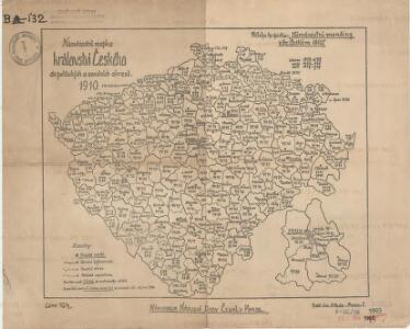
Národnostní mapka království Českého dle politických a soudních okresů 1910

Charte vom Königreich Böheim
1 : 730000 Kladsko-oblast (Polsko) Müller, Johann Christoph von Homanns Erben
Karte von dem Koenigreich Boeheim..

Příruční mapa Království českého
Čechy (Česko) Oberschall, Albin Schrober, Karel od c. a k. voj. zeměpisného ústavu
Příruční mapa Království českého
Čechy (Česko) Oberschall, Albin Schrober, Karel od c. a k. voj. zeměpisného ústavu
Handkarte des Königreiches Böhmen im Masze 1:1,000000
Čechy (Česko) Oberschall, Albin Schrober, Karel v. k.k. Milit. geograph. Institute
Charte von Boehmen

Post Charte vom Königreiche Böhmen
1 : 1200000 Česko
Post Charte vom Königreiche Böhmen
1 : 1200000 Česko
Post charte vom Königreiche Böhmen
1 : 1200000 Česko
Post charte vom Königreiche Böhmen
1 : 1200000 Česko
Post Charte vom Königreiche Böhmen
1 : 1200000 Česko
Post Charte vom Königreiche Böhmen
1 : 1200000 Česko
Post Charte vom Königreiche Böhmen
1 : 1200000 Česko
Post Charte vom Königreiche Böhmen
1 : 1200000 Česko
Post Charte vom Königreiche Böhmen
1 : 1200000 Česko
Post Charte vom Königreiche Böhmen
1 : 1200000 Česko
Bohemia
1 : 840000 Česko
Mappa chorographica novissima et completissima totius regni Bohemiae in duodecim circulos divisae cum comitatu Glacensi et districtu Egerano adiunctis circumiacentium regionum partibus conterminis ex accurata totius regni perlustratione et geometrica dimensione mandato caesareo instituta in hanc formam redacta et ad usum commodum nec non omnia singula distinctius cognoscenda XXV. sectionibus exhibita
1 : 230000 Česko Müller, Johann Christoph Herz, Johann Daniel Michael Kauffer
Mappa Geographica Regni Bohemiae In Duodecim Circulos Divisae
1 : 276000 Česko Müller, Johann Christoph Herz, Johann Daniel Michael Kauffer
Schul- u. Volkskarte v. Böhmen
1 : 1000000 Čechy (Česko) Stelzig, Heinrich Heinrich Stelzig
General - Karte vom Königreich Böhmen

Cestovní mapa Království českého
1 : 600000 Čechy (Česko) Wagner, Jan Eduard F. Kytka
Mapa Království českého pro automobilisty
1 : 560000 Česko Bayer, J. L. Jos. L. Švíkal
Das Koenigreich Boehmen
1 : 860000 Siebert, A. Berg, Carl A. Siebert
Statistisch-topographische Industrie Karte des Koenigreiches Boehmen...

Přehled rozlohy krajin, podle kterých pořádají se hospodářské výstavy krajinské v Království českém
od c.k. vlastencké společnosti hospodářské v Království českém
Přehled rozlohy krajin, podle kterých pořádají se hospodářské výstavy krajinské v Království českém
od c.k. vlastencké společnosti hospodářské v Království českém
Hydrographische Übersichtskarte des Elbe-Gebietes und des in Böhmen gelegenen Oder-Gebietes