Maps of India

Uebersichts-Karte der ethnographischen Verhältnisse von Asien und von den angrenzenden Theilen Europa'sbearbeitet und herausgegeben mit Unterstützung der kaiserlichen Akademie der Wissenschaften in Wien von Vinzenz v. Haardt
Hartenthurn, Vincenz
Ost Indien mit besonderer Berücksichtigung der englischen Besitzungen
Geographischer Atlas über alle Theile der Erde Ziegler, Jakob Melchior Verlag von Dietrich Reimer
[Ost Indien, Mit besonderer Berücksichtigung der englischen Besitzungen]
Geographischer Atlas über alle Theile der Erde Ziegler, Jakob Melchior Verlag von Joh. Wurster um Comp.
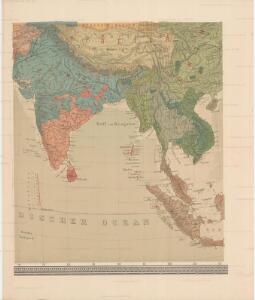
India.
1 : 14500000 Menke, Th.
Undecima Asiae Tabula [Karte], in: Claudii Ptolemei viri Alexandrini mathematice discipline philosophi doctissimi geographie opus [...], S. 223.
1 Karte aus Atlas Waldseemüller, Martin [und Ptolemaeus, Claudius] Übelin, Georg
Composite: Indes.
1 : 10000000 Bonne, Rigobert, 1727-1794
Indes Orientales.
1 : 16250000 Bonne, Rigobert, 1727-1794
India int. Gangem merid. India ext. Gangem, Sinarum situs
1 : 7600000 Ganga (Indie a Bangladéš) Reichard, Christian Gottlieb Campius, D. a D. Campio
Composite: Carte Generale des Indies.
1 : 9500000 Vivien de St Martin, L.
Ost-Indien
Handatlas über alle Theile der Erde und über das Weltgebäude Stieler, Adolf Justus Perthes
Ostindien
Neuester Schul-Atlas Walch, Johann im Verlag bei Joh. Walch
Ostindien
Allgemeiner Atlas [Walch, Johannes] im Verlag bei Johannes Walch
Ostindien.
1 : 22000000 Reichard, C. G.
Ost-Indien mit den Inseln
Hand-Atlas über alle Theile der Erde nach dem neuesten Zustande und über das Weltgebäude Stieler, Adolf bei Justus Perthes
Ost-Indien mit den Inseln
Hand-Atlas über alle Theile der Erde nach dem neuesten Zustande und über das Weltgebäude Stieler, Adolf bei Justus Perthes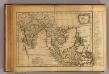
Les Indes Orientales.
1 : 29000000 Lattre, Jean
Ost Indien
Hypsometrischer Atlas Ziegler, Jakob Melchior Topogr. Anstalt v. J. Wurster u. Comp.

Ostindien mit den Inseln
Schul-Atlas über alle Theile der Erde nach dem neuesten Zustande, und über das Weltgebäude Stieler, Adolf bei Justus Perthes
Ost Indien.
1 : 9500000 Ziegler, J. M.
India
1 : 19000000 Asie jihovýchodní Spruner, Karl von Justus Perthes
Ost Indien
Stieler's Hand-Atlas Stieler, Adolf bei Justus Perthes
CARTE DES INDES ORIENTALES
1 : 10700000 Asie jihovýchodní Mayer, Tobias Apres de Mannevillette, Jean-Baptiste-Nicolas-Denis d' Heritiers de Homan[n]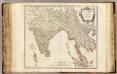
Indes Orientales.
1 : 8500000 Robert de Vaugondy, Gilles, 1688-1766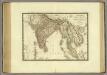
Carte generale des Indes.
1 : 10300000 Brue, Adrien Hubert, 1786-1832
Ostindien
Asie jižní im Verlage des Kunst u. Industrie Comptoirs
Ost-Indien
[Allgemeiner Atlas über alle Theile der Erde in 29 Blättern] Ziegler, Jakob Melchior Top. Anstalt v. J. Wurster u. Comp.
Hindostan Or British India.
1 : 14630000 Johnson, A.J.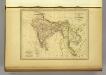
l'Indie.
1 : 20200000 Malte-Brun, Conrad, 1775-1826