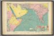
Maps of Indian Ocean

Uebersichts-Karte der ethnographischen Verhältnisse von Asien und von den angrenzenden Theilen Europa'sbearbeitet und herausgegeben mit Unterstützung der kaiserlichen Akademie der Wissenschaften in Wien von Vinzenz v. Haardt
Hartenthurn, Vincenz
[Indischer Ozean, westlicher Teil]
1 Karte : Kupferdruck ; 57 x 45 cm Doncker Hendrik Doncker
Occidentalior tractus Indiarum Orientalium à promontorio Bonæ Spei ad C. Comorin
1 Karte : Kupferdruck ; 43 x 54 cm Renard à L. Renard
[138][141] Occidentalior Tractus Indiarum Orientalium ..., uit: Atlas sive Descriptio terrarum orbis
Annotatie: Gedigitaliseerde versie. Amsterdam. Heiloo : Picturae (vervaardiger), 2015. tiff-bestand. Gedigitaliseerd: 07-01-2015; Origineel: Universiteitsbibliotheek Vrije Universiteit (XL.05127.-) ; Netherlands; Titelpagina ontbreekt Wit, Frederik de Amsterdam : Frederick de Wit
Presbiteri Iohannis, Sive, Abissinorum imperii Descriptio. [Karte], in: Theatrum orbis terrarum, S. 314.
1 Karte aus Atlas Ortelius, Abraham
Presbiteri Iohannis, Sive, Abissinorum imperii Descriptio. [Karte], in: Theatrum orbis terrarum, S. 415.
1 Karte aus Atlas Ortelius, Abraham Vrients, Jan Baptista
Carte Particuliere De La Mer Rouge &c. Levée Par Ordre Expres des Roys de Portugal sous qui on en a Fait la Decouverte. [Karte], in: Atlas nouveau, contenant toutes les parties du monde [...], Bd. 2, S. 228.
1 Karte aus Atlas Sanson, Nicolas Jaillot, Alexis Hubert und Mortier, Pieter
Charte der Nordküste Africas, oder die staaten Maroccos, Fes, Algier, Tunis, Tripoli, und Aegypten : nach den neuesten und besten Hülfsmitteln
1 : 5000000 Reinecke, J. C. M. (Johann Christoph Matthias), 1770-1818 Verlage des Landes Indust. Compt.
Mittel- und Nord-Africa und Arabien. Östliches Blatt
Stieler's Hand-Atlas Stieler, Adolf bei Justus Perthes
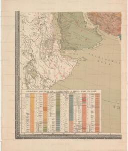
Nordost-Afrika und Arabien
Handatlas über alle Theile der Erde und über das Weltgebäude Stieler, Adolf Justus Perthes
[Mittel- und Nord-Africa und Arabien, Oestliches Blatt]
Hand-Atlas über alle Theile der Erde nach dem neuesten Zustande und über das Weltgebäude Stieler, Adolf bei Justus Perthes
[Mittel- und Nord-Africa, Oestl. Theil und Arabien]
Hand-Atlas über alle Theile der Erde und über das Weltgebäude Stieler, Adolf Justus Perthes

Aethiopia Superior vel Interior; vulgo Abissinorum sive Presbiteri Ioannis Imperium. [Karte], in: Gerardi Mercatoris et I. Hondii Newer Atlas, oder, Grosses Weltbuch, Bd. 2, S. 373.
1 Karte aus Atlas Mercator, Gerhard und Hondius, Jodocus Jansson, Jan
Aethiopia Superior vel Interior; vulgo Abissinorum sive Presbiteri Ioannis Imperium. [Karte], in: Le théâtre du monde, ou, Nouvel atlas contenant les chartes et descriptions de tous les païs de la terre, Bd. 2, S. 292.
1 Karte aus Atlas Blaeu, Willem Janszoon und Blaeu, Joan Blaeu, Willem Janszoon
Sexta Asie Tabula [Karte], in: Claudii Ptolemei viri Alexandrini mathematice discipline philosophi doctissimi geographie opus [...], S. 208.
1 Karte aus Atlas Waldseemüller, Martin [und Ptolemaeus, Claudius] Übelin, Georg
Æthiopia superior vel interior; vulgo Abissinorum sive presbiteri Ioannis Imperium
1 : 12500000 Annotatie: Kaart uitg. in de periode ca. 1688-ca. 1700; Origineel is Blad 210 in atlas factice; Annotatie geografische gegevens: Schaalstok op kaart: 100 Milliaria Germanica communia (=6,1 cm) [Amsterdam] : [F. de Wit]
Aethiopia Superior vel Interior; vulgo Abissinorum sive Presbiteri Ioannis Imperium. [Karte], in: Theatrum orbis terrarum, sive, Atlas novus, Bd. 2, S. 301.
1 Karte aus Atlas Blaeu, Joan Blaeu, Willem Janszoon
Aethiopia Superior vel Interior; vulgo Abissinorum sive Presbiteri Ioannis Imperium. [Karte], in: Novus atlas absolutissimus, Bd. 6, S. 183.
1 Karte aus Atlas Janssonius Offizin
Africa (Northeast Part). Africa (Central Part).
1 : 12070000 Hammond, C.S.
Nordost-Afrika Und Arabien.
1 : 12500000 Petermann, A.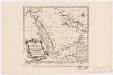
Carte de la coste d'Arabie, Mer Rouge et Golfe de Perse : tirée de la Carte de l'Océan Oriental publiée en 1740 par Ordre de Mgr le Comte de Maurepas augmentée sur des remarques particulières et dressée sur des observations astronomiques = Kaart van de Kust van Arabië, de Roode-Zee en de Gulf van Persië Gemaakt na de Fransse-Kaart van den Ooster-Ocean uitgegeven A. 1740 op Bevel van den Hre Grave de Maurepas Vermeederd op byzondere Aanmerkingen, en geschikt volgens Sterrekundige-Waarnemi
1 : 14000000 Schley, Jacobus van der, 1715-1779 Pierre de Hondt
Tabula Asiae VI. [Karte], in: Geographia universalis vetus et nova complectens Claudii Ptolemaei Alexandrini enarrationis libros VIII, S. 281.
1 Karte aus Atlas Münster, Sebastian [und Ptolemaeus, Claudius]
Ost-Africa und Madagascar
Grosser Hand-Atlas über alle Theile der Erde in 170 Karten Meyer, J. Verlag des Bibliographischen Instituts
Africa orientale
1 : 14000000 Afrika východní Antonio Vallardi
Carte des trois Arabies : tirée en partie de l'Arabe de Nubie, en partie de diuers autres autheurs
1 : 7500000 Sanson, Nicolas, 1600-1667 Chez Pierre Mariette
Haute Ethiopie, où sont l’Empire des Abissins
Haute Ethiopie, où sont l'Empire des Abissins ... et le Zanguebar.
Tabula Asiae VI. [Karte], in: Claud. Ptolemaeus. Geographia lat. cum mappis [...], S. 311.
1 Karte aus Atlas Münster, Sebastian [und Ptolemaeus, Claudius]
Ost-Africa, Madagascar.
1 : 12900000 Radefeld, Carl Christian Franz, 1788-1874