Maps of Mexico

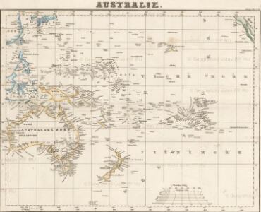
Australie.
De Grote Oceaan
Pacific Ocean Gerard van Keulen
Nieuwe afteekening van de de Zuijdt Zee van C. de Hoorn tot California als ook het Compagnies Landt ent Land van Eza
America Gerard van Keulen
Points de partage et Communications projettees.
Humboldt, Alexander von, 1769-1859
Pascaerte van Nova Hispania, Chili, Peru, en Gvatimala.
from De zee-atlas ofte water-wereld : waer in vertoont werden alle de zee-kusten van het bekende des aerd-bodems : seer dienstigh voor alle heeren en kooplieden, als oock voor alle schippers en stuurlieden / by Pieter Goos.
Map of the country between Washington & Pittsburg refering to the contemplated Chesapeake & Ohio Canal and its general route and profile, October 1826 / reduced from the general map annexed to the report upon the comtemplated canal & drawn, b
from Parts
Polynesia, Islands of Pacific.
Letts, Son & Co.
Pascaart vertoonende de zeecusten van Chili, Peru, Hispania Nova, Nova Granada, en California
1 Karte : Kupferdruck ; 43 x 55 cm Doncker by Hendrick Doncker boeckverkooper in de Nieuwe brugh steegh in 't Stuiermans gereedtschap
Sketch, surveys of the public lands, military topographical and geographical surveys west of the Mississippi.
1 : 3000000 Wheeler, G.M.
[Ost-Polynesien]
Hand-Atlas über alle Theile der Erde nach dem neuesten Zustande und über das Weltgebäude Stieler, Adolf bei Justus Perthes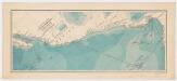
Explorations of the U. S. Fish Commission steamer Albatross : Lieut. Comdr. Z. L. Tanner U.S.N. Comdg. : Februrary to April 1891
United States Fish Commission Printed for the Museum of Comparative Zoology, Harvard University
Mappa geographica Americae Septentrionalis : ad emendatiora exemplaria adhuc edita jussu Acad. reg. scient. et eleg. litt. descripta.
from Charts and maps
Etats-Unis Mexicains, Amerique Centrale.
1 : 9300000 Brue, Adrien Hubert, 1786-1832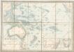
Australien

Mexico und Centro-America
Hand-Atlas über alle Theile der Erde nach dem neuesten Zustande und über das Weltgebäude Stieler, Adolf bei Justus Perthes
Spanish Dominions in North America.
1 : 19000000 Arrowsmith, Aaron; Lewis, Samuel
Spanish dominions in North America.
1 : 19000000 Arrowsmith, Aaron; Lewis, Samuel
Mexico und Centro-America
1 : 14000000 nach den besten Hülfsmitteln in Mercators Projection entworfen und gezeichnet vom Pr. L[t]. v. Stülpnagel [...] in Mercators Projection Gotha : Perthes
Mexico, Guatimala.
1 : 9500000 Hall, S. (Sidney)
Mexico & Guatemala.
1 : 11800000 Mitchell, Samuel Augustus
Mexico & Guatemala.
1 : 12000000 Tanner, Henry S.
Mexico & Guatemala.
1 : 12000000 Tanner, Henry S.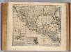
Mexico, Calif., N.M.
1 : 11000000 Bowen, Emanuel
Mexico, Guatimala.
1 : 20500000 Grigg, John
[143][146] Novae Hispaniae, Chili, Peruviae, et Guatimalae Littorae, uit: Atlas sive Descriptio terrarum orbis
Annotatie: Gedigitaliseerde versie. Amsterdam. Heiloo : Picturae (vervaardiger), 2015. tiff-bestand. Gedigitaliseerd: 07-01-2015; Origineel: Universiteitsbibliotheek Vrije Universiteit (XL.05127.-) ; Netherlands; Titelpagina ontbreekt Wit, Frederik de Amsterdam : Frederick de Wit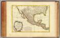
Mexique, Nlle. Mexique, Californie.
1 : 13300000 Bonne, Rigobert, 1727-1794
Carte Generale du Mexique et des Provinces-unis de l'Amerique Centrale.
1 : 15500000 Vivien de St Martin, L.
Etats-Unis Mexicains, Texas, Amerique Centrale.
1 : 9300000 Picquet, C.
Mexique.
1 : 8900000 Lapie, M. (Pierre), 1779-1850