Maps of Praha

Praha - městská hromadná doprava
1 : 40000
Přesná nivelace Velké Prahy s okolím : [přehled nivelačních tratí a osazených výškových bodů]
1 : 25000
[Prag und Umgebung]
1 : 57600 Praha (Česko) Carl Bellmann's Verlag
Spezialkarte der Umgebung von Prag

Plan der koniglichen Hauptstadt Prag mit den naechsten Umgebungen
Praha-oblast (Česko) Kral, Anton
[Umgebungen der königl. Hauptstadt Prag]
1 : 45000 Praha-oblast (Česko) Basdar
Umgebung der königl. Hauptstadt Prag
Praha-oblast (Česko) Heber, Franz Alexander Berra, Marco Marco Berra
Trigonometrische Netz der Umgebungen von der königlichen Hauptstadt Prag
1 : 90000 Praha-oblast (Česko) Jüttner, Josef
Regulační plán Velké Prahy s okolím
1 : 50000
[Mapa okolí pražského]
Praha-oblast (Česko)
[Mapa okolí pražského]
Praha-oblast (Česko)
Mapa okolí pražského
Praha-oblast (Česko)
Velká Praha a okolí

Pražský vikariát
Praha-oblast (Česko)
Praha a okolí
Praha (Česko : oblast) Kuchař, Karel
Výškopisný plán hlavního města Prahy s okolím
1 : 20000 Praha (Česko) obec Pražská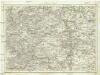
Umgebung von Prag
Praha-oblast (Česko) Biller, Bernhardt Marco Berra
Podrobné mapy zemí Koruny české v měřítku 1:75.000 a mapa vzdáleností všech míst při silnici ležících
1 : 75000 Brandýs nad Labem-Stará Boleslav (Česko : oblast) Bělohlav, Josef F. Topič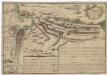
Recht wahrhaffte Vorstellung der den 6ten May A.no 1757 zwischen der kaisserl. und könig. preüss. Armée bey Prag vorgefallenen Bataille
Praha (Česko) Salzer, Ignác
Recht wahrhaffte Vorstellung der den 6ten May A.no 1757 zwischen der kasserl. und könig. preüss. Armée bey Prag vorgefallenen Bataille
Praha (Česko) Salzer, Ignác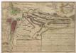
Recht wahrhaffte Vorstellung der den 6ten May A.no 1757 zwischen der kaisserl. und könig. preüss. Armée bey Prag vorgefallenen Bataille
Praha (Česko) Salzer, Ignác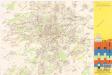
Jižní Město. - Litochleby Orientační plán 3. souboru
1 : 2500
Nový, úředně schválený plán Velké Prahy
1 : 25000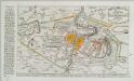
Plan der Battaille welche d. 6. Maj zwischen den Kayserl. Königl. Ungarische[n] u. Königlich Preusische[n] Armee bey Prag geliefert worden. 1757
1 : 90000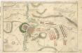
Accurate Vorstellung der zwischen den Oesterreichischen und Preussischen Armeen ... Bataille bey Prag...

Belagerung der königlicher Haupt-Stadt Prag...

Soubor map okresů Pražského kraje

Belagerung der Königl. Haupt-Stadt Prag
1 : 57000 Berounka (Česko) Werner, Bedřich Bernard Strahowsky, B.
Plan der Battaille welche d. 6. Maj zwischen der kayserlich-königlich-ungarischen und königlich preussischen Armée bey Prag geliefert worden, 1757
Praha (Česko)


