Maps of Madiun

Kaart van de Residentie Kediri : opgenomen ingevolge Gouvernements besluit d.d. 6 juli nr.8 in de jaren 1869 t/m 1875 / Topographisch Bureau, Batavia
Topographisch Bureau Batavia Batavia : Topogr[aphisch] Bureau
Kaart van de Residentie Kediri / Topographisch Bureau te Batavia, 1891
Topographisch Bureau Batavia Batavia : Topographisch Bureau
Overzichtskaart van de residentie Madioen / Topografische Inrichting
Topografische Inrichting Batavia Batavia : Topografische Inrichting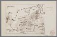
[Oudheden op Oost Java]
1 : 500000 Annotatie: Concept voor atlas van C. Lekkerkerker? [S.l. : s.n.]
Overzichtskaart rayon Kediri fabrieken
Soerabaja : [s.n.]
Madioen / prepared under the direction of the Chief of Engineers, U.S. Army by the Army Map Service
Army Map Service Washington D.C. Washington D.C. : Army Map Service
[Pacitan]
1 : 200000 Joh. C. Stemler Cz.
[Pasuruan]
1 : 200000 Joh. C. Stemler Cz.
Pasoeroean / prepared under the direction of the Chief of Engineers, U.S. Army by the Army Map Service
Army Map Service Washington D.C. Washington D.C. : Army Map Service
Modjokerto / bewerkt door J. Duyfjes
[Batavia] : Repr[oductiebedr[ijf] Top[ografische] Dienst
[Madioen]
Jáva (Indonésie)
Fabriek Poerwadadi Madioen

Oeteran / prepared under the direction of the Chief of Engineers U.S. Army, 1943 ; copied from a Dutch map dated 1926
Army Map Service U.S. Army Washington D.C. Washington D.C. : Army Map Service
[Gebied ten oosten van Tambak] / [Topographisch Bureau]
Topographisch Bureau Batavia [Batavia : Topographisch Bureau]
Peta bag[ian] djalan Kota Pradja Kediri
[S.l.] : [s.n.]
[Rendjana] : opgenomen in het jaar 1918 / Topografische Inrichting
Topografische Inrichting Batavia Batavia : Topografische Inrichting
[Sigering] : opgenomen door den Topografischen Dienst in 1916-1918 / Topografische Dienst
Topografische Dienst Batavia Batavia : Topografische Inrichting
[Soenglon Damas] : opgenomen door den Topografischen Dienst in 1918 / Topografische Dienst
Topografische Dienst Batavia Batavia : Topografische Inrichting
[Panggoel] : opgenomen in de jaren 1916-1918 / Topografische Inrichting
Topografische Inrichting Batavia Batavia : Topografische Inrichting
[Poendjoel] / [Topographisch Bureau]
Topographisch Bureau Batavia [Batavia : Topographisch Bureau]
[Djatipoera] : opgenomen door den Topografischen Dienst in 1921-1922 / Topografische Dienst
Topografische Dienst Batavia Batavia : Topografische Inrichting
[Tengaring] : opgenomen door den Topografischen Dienst in 1923-1924 / Topografische Dienst
Topografische Dienst Batavia Weltevreden (Batavia) : Reproductiebedrijf Topografische Dienst
[Toempakredja] : herzien door den Topografischen Dienst in 1921 / Topografische Dienst
Topografische Dienst Batavia Batavia : Topografische Inrichting
[Poeloeng] : opgenomen in de jaren 1914-1916 / Topografische Inrichting
Topografische Inrichting Batavia Batavia : Topografische Inrichting
[Klitik] : opgenomen door den Topografischen Dienst in 1921 / Topografische Dienst
Topografische Dienst Batavia Batavia : Topografische Dienst
[Pasejan] / [Topographisch Bureau]
Topographisch Bureau Batavia [Batavia : Topographisch Bureau]
[Kawedanan] : opgenomen door den Topografischen Dienst in 1918 / Topografische Dienst
Topografische Dienst Batavia Batavia : Topografische Dienst
[Waroekkalong] : opgenomen in 1919 / Topografische Inrichting
Topografische Inrichting Batavia Batavia : Topografische Inrichting
[Pogalan] : opgenomen door den Topografischen Dienst in 1916-1919 / Topografische Dienst
Topografische Dienst Batavia Batavia : Topografische Inrichting


