Maps of Jawa Barat

[Tondjong] / [Topographisch Bureau]
Topographisch Bureau Batavia [Batavia : Topographisch Bureau]
Toblong / copied from a Dutch map dated 1934 [by the] Survey Production Centre South East Asia ; reproduced from kodalines by 110 Map Production Co[mpan]y R.E., Dec[ember] 1945
Survey Production Centre South East Asia [S.l.] : Survey Production Centre South East Asia
[Pangligaran] / [Topographisch Bureau]
Topographisch Bureau Batavia [Batavia : Topographisch Bureau]
[Tjimoentjang] / [Topographisch Bureau]
Topographisch Bureau Batavia [Batavia : Topographisch Bureau]
Tochten van uit het hotel "Sanatorium Garoet" en van uit het hotel "Villa Paulina" / Nederlandsch-Indische Hotelvereeniging
Nederlandsch-Indische Hotelvereeniging [Batavia etc. : G. Kolff
Garoet / prepared under the direction of the Chief of Engineers, U.S. Army by the Army Map Service
Army Map Service Washington D.C. Washington D.C. : Army Map Service
[Pameungpeuk]
1 : 200000 Joh. C. Stemler Cz.
West-Java : met aanwijzing van de bevolkingsdichtheid per district volgens de uitkomsten der volkstelling in 1930
Topografische Dienst Batavia [Batavia : Topografische Dienst]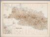
3. West Java, uit: Atlas van Nederlandsch Oost-Indië / samengest. door Topographisch Bureau te Batavia van 1897-1904
Annotatie: Omgewerkte versie van: Atlas der Nederlandsche bezittingen in Oost-Indië / naar de nieuste bronnen samengest. door J.W. Stemfoort en J.J. ten Siethoff. - 's-Gravenhage : Topographische Inrichting, [ca. 1885] Topographisch Bureau, Batavia 's-Gravenhage : Topographische Inrichting
West-Java / Topografische Dienst
Topografische Dienst Batavia Batavia : Reproductiebedrijf Topografische Dienst
West-Java : bijgewerkt tot 1 November 1935 / Reproductiebedrijf Topografische Dienst
Topografische Dienst Batavia Batavia : Topografische Dienst
Kaart van West-Java : Eerste militaire afdeeling / [door J.W Stemfoort en J.J. ten Siethoff ; gereproduceerd op last van het Departement van Koloniën, aan de Topographische Inrichting te 's-Gravenhage, onder leiding van den Directeur C.A. Eckstein]
Ministerie van Koloniën Den Haag s-Gravenhage : Departement van Koloniën
Djawa Barat
Bandung : 'Hovic' Visser
Kaart van het Rijk van Bantam, Jacatra & Cheribon op het eiland Java / door Js. van den Bosch ; gegraveerd door C. van Baarsel en Zoon
C. van Baarsel en Zoon s-Gravenhage ; Amsterdam : Gebroeders van Cleef
Java en Madoera / ontworpen en geteekend door J. Kuijper ; kopergravure door J.C. Zurcher
Leeuwarden : Hugo Suringar
Java en Madoera / Ontworpen en geteekend door J. Kuijper ; kopergravure door J.C. Zürcher
Tjeenk Willink, W.E.J. Zwolle Zwolle : Tjeenk Willink, W.E.J.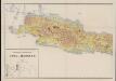
Geologische overzichtskaart van Java en Madoera
1 : 500000 West-Blatt Verbeek, R. D. M. Joh. G. Stemler Cz.
[Geologische kaart van West-Java]
1 : 3500000 Annotatie: Concept voor atlas van C. Lekkerkerker?; Met doorsnede van de hoogste bergtoppen [S.l. : s.n.]
Batavia / Survey of India
Survey of India [S.l.] : Survey of India
Batavia / Topografische Inrichting
Topografische Dienst Batavia Batavia : Topografische Inrichting
Algemeene afstandswijzer van het eiland Java / vervaardigd op het Topographisch Bureau der Genie-Directie Batavia, 1842 ; vervaard[igd] en gegrav[eerd] door H. Dickmann
Topographisch Bureau der genie Directie Batavia Batavia : Topographisch Bureau der Genie-Directie
Spoor- en tramwegkaart van Java en Madoera : tevens aanwijzende het bij het Indisch Besluit d.d. 12 october 1893 no. 31 vastgestelde Algemeen spoorwegplan voor Java
Topographisch Inrichting Batavia [Batavia] : Top[ographische] Inr[ichting]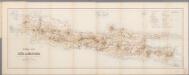
[Kaart], uit: Spoorwegkaart van Java en Madoera : met aanduiding der overige hoofdcommunicatie-middelen te land en ter zee / te zamengest. door J.W. Stemfoort en J. Hora Adama
1 : 1000000 Stemfoort, J. W.; Hora Adama, J. 's-Gravenhage : Smulders
Oudheden op Java
1 : 3000000 Annotatie: Concept voor atlas van C. Lekkerkerker? [S.l. : s.n.]
Kaart van het Eiland Java
1 : 350000 Jáva (Indonésie) Junghuhn, Franz Wilhelm A.J. Junghuhn
Kaart aangevende de nieuwe administratieve indeeling van Java en Madoera / met toelichting door C. Lekkerkerker
Amsterdam : De Bussy
Kaart van Java en Madura
[Batavia : Landsdrukkerij]
Java and Madoera / drawn by the War Office, 1941 ; printed at the Survey for India Offices (P.Z.O.)
War Office [Washington D.C.] : War Office
Historische kaart van Java
Amsterdam : Tresling
![[Tondjong] / [Topographisch Bureau]](https://images-2.georeferencer.com/images/iiif/651354874755/full/,300/0/native.jpg)

