Maps of Papua

Kaondo / Topografische Dienst
Topografische Dienst Delft [Delft] : Topografische Dienst
Bladwijzer van het eiland Noemfoor en Zuid-Biak
[S.l. : s.n.]
West-Japen / Netherlands Topographic Service
Netherlands Topographic Service Delft [Delft] : Netherlands Topographic Service
West Japen / prepared under the direction of the Chief Engineer by Base Map Plant U.S. Army, June 1944
War Department Washington D.C. . Corps of Engineers U.S. Army [Washington D.C.] : Corps of Engineers U.S. Army, War Department
Geelvinkbaai / U.S. Army Map Service
U.S. Army Map Service Washington D.C. Washington D.C. : U.S. Army Map Service
Bladwijzer van Eilanden Biak-Japen en Kuststrook Verkam-Hollandia
[S.l. : s.n.]
Geelvink-baai / samengesteld en gedrukt bij den Topografischen Dienst
Topografische Dienst Batavia Batavia : Topografische Dienst
Geologische overzichtskaart van den Nederlandsch Oost-Indischen Archipel : Vogelkop / bewerkt door J. Zwierzycki
Landsdrukkerij Weltevreden (Batavia) [Weltevreden (Batavia) : Landsdrukkerij]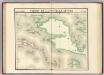
Partie, Nouvelle Guinee. Oceanique no. 22.
1 : 1641836 Vandermaelen, Philippe, 1795-1869
Kaart van Nederlandsch Nieuw Guinea en de Papoesche Eilanden
[S.l. : s.n.]
Nederlands Nieuw-Guinea / [Netherlands Topographic Service]
Netherlands Topographic Service Delft [Delft : Netherlands Topographic Service]
Nederlandsch-Nieuw-Guinee
Topographische Inrichting Batavia Batavia : Top[ographische] Inr[ichting]
Kaart van Nederlandsch Nieuw-Guinea en omliggende eilanden / Topographisch Bureau
Topographisch Bureau Batavia Batavia : Topographisch Bureau
Západní Irian

Overzichtskaart van de Residentie Amboina en de Afdeeling Noord-Nieuw Guinea / samengesteld door het Encyclopaedisch Bureau [in] 1915
Encyclopaedisch Bureau Batavia Batavia : G. Kolff & Co.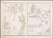
16. [Ambon, Molukken], uit: Atlas van Nederlandsch Oost-Indië / samengest. door Topographisch Bureau te Batavia van 1897-1904
Annotatie: Omgewerkte versie van: Atlas der Nederlandsche bezittingen in Oost-Indië / naar de nieuste bronnen samengest. door J.W. Stemfoort en J.J. ten Siethoff. - 's-Gravenhage : Topographische Inrichting, [ca. 1885] Topographisch Bureau, Batavia 's-Gravenhage : Topographische Inrichting
Carte des iles Moluques
1 : 3425000 par P. Melvill de Carnbee gravé par D. Heyse La Haye : lith de Ch. van Lier
[Schetskaart van Nieuw-Guinea] / Topografische Dienst
Topografische Dienst Batavia Batavia : Reproductiebedrijf Topografische Dienst
[Nieuw Guinea] / Topografische Dienst
Topografische Dienst Batavia Batavia : Reproductiebedrijf Topografische Dienst
Elf kaarten van Nieuw-Guinea / Directie Ned[erlands] Nieuw Guinea, Ministerie van Binnenlandse Zaken
Ministerie van Binnenlandse Zaken 's-Gravenhage . Directie Nederlands Nieuw Guinea ['s-Gravenhage : Staatsdrukkerij]
Schetskaart van Nieuw-Guinea / Topografische Dienst
Topografische Dienst Batavia Batavia : Reproductiebedrijf Topografische Dienst
Vegetatiekaart van Nieuw-Guinea
Topografische Dienst Delft Delft : Topografische Dienst
Schetskaart van Nieuw Guinea / Topografische Dienst
Topografische Dienst Batavia Batavia : Reproductiebedrijf Topografische Dienst
Nieuw Guinea / Topografische Dienst
Topografische Dienst Batavia Batavia : Reproductiebedrijf Topografische Dienst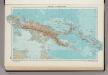
335. New Guinea, Solomon Islands. The World Atlas.
1 : 7500000 USSR (Union of Soviet Socialist Republics).
Blad VII Siding, uit: Residentie Wester-Afdeeling van Borneo / Topographisch Bureau
1 : 200000 titelvariant: Residentie Westerafdeeling van Borneo; Annotatie: Titelvariant: Residentie Westerafdeeling van Borneo; Voor aanwezige bladen zie overzichtsblad; Annotatie geografische gegevens: Opname: 1886-1895 Topographisch Bureau, Batavia Batavia : Topographisch Bureau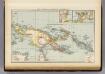
New Guinea, Papuan Archipelago.
1 : 10000000 Andree, Richard; Times (London, England)
Indonesia
IPPRESS Djakarta [Djakarta] : IPPRESS
Indonesië : voorlopige staatkundige ordening, bijgewerkt tot 1 october 1949
[S.l. : s.n.]


