Maps of Kediri

Peta bag[ian] djalan Kota Pradja Kediri
[S.l.] : [s.n.]
[Ngasem] / [Topographisch Bureau]
Topographisch Bureau Batavia [Batavia : Topographisch Bureau]
Kaart van de Hoofdplaats Kediri en omstreken / Topographisch Bureau
Topographisch Bureau Batavia Batavia : Topographisch Bureau
[Blabak] / [Topographisch Bureau]
Topographisch Bureau Batavia [Batavia : Topographisch Bureau]
[Boeloesan] / [Topographisch Bureau]
Topographisch Bureau Batavia [Batavia : Topographisch Bureau]
Hoofdplaats Kediri / Top[ographische] Inr[ichting]
Topographische Inrichting Batavia Batavia : Top[ografische] Inr[ichting]
[Kranggan] / [Topographisch Bureau]
Topographisch Bureau Batavia [Batavia : Topographisch Bureau]
[Blimbing] / [Topographisch Bureau]
Topographisch Bureau Batavia [Batavia : Topographisch Bureau]
[Datengan] / [Topographisch Bureau]
Topographisch Bureau Batavia [Batavia : Topographisch Bureau]
Overzichtskaart rayon Kediri fabrieken
Soerabaja : [s.n.]
[Pasuruan]
1 : 200000 Joh. C. Stemler Cz.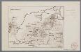
[Oudheden op Oost Java]
1 : 500000 Annotatie: Concept voor atlas van C. Lekkerkerker? [S.l. : s.n.]
Kaart van de Residentie Kediri : opgenomen ingevolge Gouvernements besluit d.d. 6 juli nr.8 in de jaren 1869 t/m 1875 / Topographisch Bureau, Batavia
Topographisch Bureau Batavia Batavia : Topogr[aphisch] Bureau
Kaart van de Residentie Kediri / Topographisch Bureau te Batavia, 1891
Topographisch Bureau Batavia Batavia : Topographisch Bureau
Kaart van de Residentie Soerabaja / Topographisch Bureau
Topographisch Bureau Batavia Batavia : Topographisch Bureau
Overzichtskaart van de residentie Madioen / Topografische Inrichting
Topografische Inrichting Batavia Batavia : Topografische Inrichting
Oost Java = East Java / Reproductiebedrijf Top[ografische] Dienst, Batavia
Topografische Dienst Batavia Batavia : Officieële Vereeniging voor Toeristenverkeer in Nederlandsch Indië
Kaart der landbouw-ondernemingen in Oost-Java : (Soerabaja, Kediri, Pasoeroean, Probolinggo en Besoeki) / bewerkt naar de oorspronkelijke teekeningen van den heer H.Ph.Th. Witkamp ; uitgave van J.H. de Bussy Amsterdam, 1892
Amsterdam : J.H. de Bussy
Schetskaart der expeditie van Anthonio Hurdt in Java's binnenland
['s-Gravenhage : Martinus Nijhoff]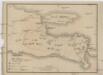
Vulkan Karte von Ost Java
1 : 1300000 Jáva (Indonésie)
Djember / Survey of India
Survey of India [S.l.] : Survey of India
Java
['s-Gravenhage : Martinus Nijhoff]
Pasoeroean / Survey of India
Survey of India [S.l.] : Survey of India
Kaart van een gedeelte van het Eiland Java : uitgemaakt hebbende het tooneel van den oorlog van 1825-1830 / door L.M. Lange. Majoor bij het Nederl[andsch] Ind[isch] Leger, Ridder der Militaire Willems Orde ; geteekend en op 61/4 verkleind door H. Hama, Gead. Landmeter

Kaart van Oost-Java : Derde militaire afdeeling / [door J.W Stemfoort en J.J. ten Siethoff ; gereproduceerd op last van het Departement van Koloniën, aan de Topographische Inrichting te 's-Gravenhage, onder leiding van den Directeur C.A. Eckstein]
Ministerie van Koloniën Den Haag s-Gravenhage : Departement van Koloniën
4. Midden Java, uit: Atlas van Nederlandsch Oost-Indië / samengest. door Topographisch Bureau te Batavia van 1897-1904
Annotatie: Omgewerkte versie van: Atlas der Nederlandsche bezittingen in Oost-Indië / naar de nieuste bronnen samengest. door J.W. Stemfoort en J.J. ten Siethoff. - 's-Gravenhage : Topographische Inrichting, [ca. 1885] Topographisch Bureau, Batavia 's-Gravenhage : Topographische Inrichting
Kaart van een spoorweg tusschen Madioen en Soerakarta
Amsterdam : De Bussy
Overzichtskaart der spoor- en tramwegen in Midden-Java / Nederlandsch-Indische Spoorweg-Maatschappij
Nederlandsch-Indische Spoorweg-Maatschappij [Semarang] : Nederlandsch-Indische Spoorweg-Maatschappij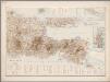
5. Oost Java, uit: Atlas van Nederlandsch Oost-Indië / samengest. door Topographisch Bureau te Batavia van 1897-1904
Annotatie: Omgewerkte versie van: Atlas der Nederlandsche bezittingen in Oost-Indië / naar de nieuste bronnen samengest. door J.W. Stemfoort en J.J. ten Siethoff. - 's-Gravenhage : Topographische Inrichting, [ca. 1885] Topographisch Bureau, Batavia 's-Gravenhage : Topographische Inrichting
![Peta bag[ian] djalan Kota Pradja Kediri](https://images-2.georeferencer.com/images/iiif/751445204346/full/,300/0/native.jpg)

