Maps of Kuta

Ini gambar District Koeta

Denpasar / gecopieerd op het Waterstaat Bureau te Singaradja, 28-1-1915, [door] de E.A.W.A., w.g. A. Glastra van Loon
Waterstaat Bureau Singaradja
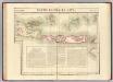
Kota Denpasar

Onderafdeeling Badoeng

Zuid Bali : administratieve indeeling

Schetskaart van Midden Bali / Topographische Inrichting
Topographische Inrichting Batavia Batavia : Topographische Inrichting
Singaradja / prepared under the direction of the Chief of Engineers, U.S. Army by the Army Map Service
Army Map Service Washington D.C. Washington D.C. : Army Map Service
Schetskaart van het eiland Bali
[Batavia : Topographische Inrichting?]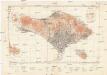
East Indies 1:200 000
1 : 200000 Bali (Indonésie : ostrov) Army map service
Bali / Topografische Dienst
Topografische Dienst Batavia Batavia : Reproductiebedrijf Topografische Dienst
Bali
[S.l. : s.n.]
Schetskaart van het eiland Bali / Topographische Inrichting
Topografische Inrichting Batavia Batavia : Topographische Inrichting
Schetskaart van het eiland Bali / Topographische Inrichting
Koninklijke Vereeniging Java Motor Club Semarang Batavia : Topographische Inrichting
Schetskaart van het eiland Bali / Topographische Inrichting
Topographische Inrichting Batavia Batavia : Topographische Inrichting
Kaart van het Eiland Bali / Topographisch Bureau Batavia, april 1897
Topographisch Bureau Batavia Batavia : Topographisch Bureau
Oudheidkundige kaart van Bali / door L.C. Heyting en C. Lekkerkerker, Scheveningen 1925 ; gecop[ieeerd] door M. Kartodisastro, aug[ustus] 1925
[S.l. : s.n.]
Kaart van het eiland Bali / steendr[uk] v[an] E. Spanier te 's Hage
s-[Graven]hage : E. Spanier
Kaart van het eyland Bali
1 : 350000 [Dordrecht etc.] : J. van Braam en G. Onder de Linden exc.
Idjen Hoogland en Bali = Idjen Highland and Bali / Reproductiebedrijf Topografische Dienst, Batavia
Topografische Dienst Batavia Batavia : Officieële Vereeniging voor Toeristenverkeer
Kaart van de eilanden Balie en Lombok
1 : 650000 [Groningen] : ter steendrukkerij van A. Oomkens, J. zoon
Banjoewangi / Survey of India
Survey of India [S.l.] : Survey of India
15. Kaart van de Kleine Soenda Eilanden, uit: Atlas van Nederlandsch Oost-Indië / samengest. door Topographisch Bureau te Batavia van 1897-1904
Annotatie: Omgewerkte versie van: Atlas der Nederlandsche bezittingen in Oost-Indië / naar de nieuste bronnen samengest. door J.W. Stemfoort en J.J. ten Siethoff. - 's-Gravenhage : Topographische Inrichting, [ca. 1885] Topographisch Bureau, Batavia 's-Gravenhage : Topographische Inrichting
Singaradja / samengesteld en gedrukt bij den Topografischen Dienst
Topografische Dienst Batavia Batavia : Topografische Dienst
Singaradja / U.S. Army Map Service
U.S. Army Map Service Washington D.C. Washington D.C. : U.S. Army Map Service
Carte hypsométrique de l'Archipel des Indes Orientales / par P. Melvill de Carnbee
La Haye : Heyse
Oost Java : [geologische kaart]
1 : 1000000 Annotatie: Concept voor atlas van C. Lekkerkerker?; Met doorsnede van de hoogste bergtoppen (vertikale schaal 1:40.000) [S.l. : s.n.]
Sleeswijk's kaart van Nederlands Oost-Indië
J.A. Sleeswijk, Bussum Bussum : J.A. Sleeswijk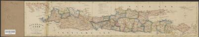
Het eiland Java benevens Bali
1 : 1750000 Amsterdam : Seyffardt's Boekhandel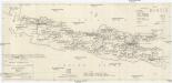
Railroads Java
1 : 2857000 Jáva (Indonésie) Engineer Research Office