Maps of Bali

Oudheidkundige kaart van Bali / door L.C. Heyting en C. Lekkerkerker, Scheveningen 1925 ; gecop[ieeerd] door M. Kartodisastro, aug[ustus] 1925
[S.l. : s.n.]
Kaart van het Eiland Bali / Topographisch Bureau Batavia, april 1897
Topographisch Bureau Batavia Batavia : Topographisch Bureau
Schetskaart van het eiland Bali / Topographische Inrichting
Topographische Inrichting Batavia Batavia : Topographische Inrichting
Schetskaart van het eiland Bali / Topographische Inrichting
Koninklijke Vereeniging Java Motor Club Semarang Batavia : Topographische Inrichting
Schetskaart van het eiland Bali / Topographische Inrichting
Topografische Inrichting Batavia Batavia : Topographische Inrichting
Kaart van het eiland Bali / steendr[uk] v[an] E. Spanier te 's Hage
s-[Graven]hage : E. Spanier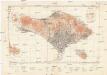
East Indies 1:200 000
1 : 200000 Bali (Indonésie : ostrov) Army map service
Bali
[S.l. : s.n.]
Bali / Topografische Dienst
Topografische Dienst Batavia Batavia : Reproductiebedrijf Topografische Dienst
Schetskaart van het eiland Bali
[Batavia : Topographische Inrichting?]
Zuid Bali : administratieve indeeling

Kaart der Afdeelingen Boeleleng en Djambrana, Eiland Bali / vervaardigd in 1885 door den inlandschen landmeter Raden Mas Ronodirdjo onder toezicht van den Controleur 1ste Kl[asse] F.A. Liefrinck
[Batavia : Topographisch Bureau]
[Recto], uit: Schetskaart van het eiland Bali : (oostelijk deel)
1 : 250000 Annotatie: Bijlage bij: De Nieuwe Nieuwe Rotterdamsche Courant; Met toelichting (voortgezet op verso) [S.l. : s.n.]
Singaradja / prepared under the direction of the Chief of Engineers, U.S. Army by the Army Map Service
Army Map Service Washington D.C. Washington D.C. : Army Map Service
Banjoewangi / prepared under the direction of the Chief of Engineers, U.S. Army by the Army Map Service
Army Map Service Washington D.C. Washington D.C. : Army Map Service
[Rogojampi]
1 : 200000 Joh. C. Stemler Cz.
Schetskaart van Midden Bali / Topographische Inrichting
Topographische Inrichting Batavia Batavia : Topographische Inrichting
Schetskaart van de onderafdeeling Kloengkoeng / Waarnemend Controleur van Kloengkoeng [J.F. Mirandolle]

Kaart der Afdeeling Djambrana, Eiland Bali / vervaardigd in 1885 door den inlandschen landmeter Raden Mas Ronodirdjo onder toezicht van den Controleur der 1e Kl[asse] b[ij] h[et] Binnenlandsch Bestuur F.A. Liefrinck
[Batavia : Topographisch Bureau]
[Karangasem] / dibikin oleh I Made Poegleg

Onderafdeeling Badoeng

Schetskaart Onderafdeeling Gianjar

Ini gambar District Koeta

Schetskaart district Soekasada

[Banjoewangi] / Topographische Inrichting
Topographische Inrichting Batavia Batavia : Topographische Inrichting
[Bama] / Topographische Inrichting
Topographische Inrichting Batavia Batavia : Topographische Inrichting
[Kalipoera] / Topographische Inrichting
Topographische Inrichting Batavia Batavia : Topographische Inrichting
Kaart van de Hoofdplaats Banjoewangi en omstreken / Top[ographisch] Bureau
Topographisch Bureau Batavia Batavia : Topographisch Bureau
Denpasar / gecopieerd op het Waterstaat Bureau te Singaradja, 28-1-1915, [door] de E.A.W.A., w.g. A. Glastra van Loon
Waterstaat Bureau Singaradja
![Oudheidkundige kaart van Bali / door L.C. Heyting en C. Lekkerkerker, Scheveningen 1925 ; gecop[ieeerd] door M. Kartodisastro, aug[ustus] 1925](https://images-2.georeferencer.com/images/iiif/405190667179/full/,300/0/native.jpg)

