Maps of Jawa Timur

Sitoebondo / prepared under thee direction of the Chief of Engineers, U.S. Army by the Army Map Service
Army Map Service Washington D.C. Washington D.C. : Army Map Service
[Situbondo]
1 : 200000 Joh. C. Stemler Cz.
[Gili Ijang]
1 : 200000 Joh. C. Stemler Cz.
[Soemberanjar] / herzien door de 3e Landrente-Opnemingsbrigade
Batavia : Topographische Inrichting
[Djangkar Lor] / herzien door de 3e Landrente-Opnemingsbrigade
Batavia : Topographische Inrichting
[Asembagoes] / herzien door de 3e Landrente-Opnemingsbrigade
Batavia : Topographische Inrichting
t Vorstendom of Landschap Balamboang
[te Dordrecht : by Joannes van Braam]
Sitoebondo / Survey of India
Survey of India [S.l.] : Survey of India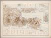
5. Oost Java, uit: Atlas van Nederlandsch Oost-Indië / samengest. door Topographisch Bureau te Batavia van 1897-1904
Annotatie: Omgewerkte versie van: Atlas der Nederlandsche bezittingen in Oost-Indië / naar de nieuste bronnen samengest. door J.W. Stemfoort en J.J. ten Siethoff. - 's-Gravenhage : Topographische Inrichting, [ca. 1885] Topographisch Bureau, Batavia 's-Gravenhage : Topographische Inrichting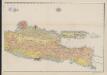
Geologische overzichtskaart van Java en Madoera
1 : 500000 Ost-Blatt Verbeek, R. D. M. Joh. G. Stemler Cz.
Ost-Java
1 : 1000000 Schulze, F. [s.n.]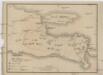
Vulkan Karte von Ost Java
1 : 1300000 Jáva (Indonésie)
Kaart van het eiland Madura en de oosthoek van het eiland Java / door Js. van den Bosch ; gegraveerd door C. van Baarsel en Zoon
C. van Baarsel en Zoon s-Gravenhage ; Amsterdam : Gebroeders van Cleef
Kaart van Oost-Java : Derde militaire afdeeling / [door J.W Stemfoort en J.J. ten Siethoff ; gereproduceerd op last van het Departement van Koloniën, aan de Topographische Inrichting te 's-Gravenhage, onder leiding van den Directeur C.A. Eckstein]
Ministerie van Koloniën Den Haag s-Gravenhage : Departement van Koloniën
Oost-Java / Topografische Dienst
Topografische Dienst Batavia Batavia : Reproductiebedrijf Topografische Dienst
Oost-Java bijgewerkt tot 1 November 1935 / Reproductiebedrijf Topografische Dienst
Topografische Dienst Batavia Batavia : Topografische Dienst
Idjen Hoogland en Bali = Idjen Highland and Bali / Reproductiebedrijf Topografische Dienst, Batavia
Topografische Dienst Batavia Batavia : Officieële Vereeniging voor Toeristenverkeer
Kaart der landbouw-ondernemingen in Oost-Java : (Soerabaja, Kediri, Pasoeroean, Probolinggo en Besoeki) / bewerkt naar de oorspronkelijke teekeningen van den heer H.Ph.Th. Witkamp ; uitgave van J.H. de Bussy Amsterdam, 1892
Amsterdam : J.H. de Bussy
Kaart van de eilanden Balie en Lombok
1 : 650000 [Groningen] : ter steendrukkerij van A. Oomkens, J. zoon
Overzichtskaart van de Residentie Besoeki / Topographisch Bureau
Topographisch Bureau Batavia Batavia : Topographisch Bureau
Kaart der Residentie Besoeki / Topographisch Bureau te Batavia, april 1887
Topographisch Bureau Batavia Batavia : Topographisch Bureau
Overzichtskaart van de Residentie Madoera / Top[ografische] Inr[ichting]
Topografische Inrichting Batavia Bat[avia] : Top[ografische] Inr[ichting]
Madoera Stoomtram Maatschappij
Madoera Stoomtram Maatschappij Amsterdam [S.l. : Madoera Stoomtram Maatschappij]
Idjen Hoogland / Top[ografische] Inr[ichting]
Topografische Inrichting Batavia Bat[avia] : Top[ographische] Inr[ichting]
[Soembergading] / herzien door de 3e Landrente-Opnemingsbrigade
Batavia : Topographische Inrichting
[Kaart van den Idjen-Vulkaan]
[Java und Madoera, geologische Detailkarten und Profile] Verbeek, R. D. M. Joh. C. Stemler Cz.
Makassar / Topografische Inrichting
Topografische Dienst Batavia Batavia : Topografische Inrichting
Makassar / U.S. Army Map Service
U.S. Army Map Service Washington D.C. Washington D.C. : U.S. Army Map Service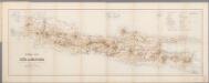
[Kaart], uit: Spoorwegkaart van Java en Madoera : met aanduiding der overige hoofdcommunicatie-middelen te land en ter zee / te zamengest. door J.W. Stemfoort en J. Hora Adama
1 : 1000000 Stemfoort, J. W.; Hora Adama, J. 's-Gravenhage : Smulders


