Maps of Bandung

Overzichtskaart betreffende den ontworpen spoorweg van Padalarang naar Krawang
[S.l. : s.n.]
[Goenoeng Boekittoenggoel] / Topographisch Bureau, herzien in het jaar 1909
Topographisch Bureau Batavia Batavia : Topografisch Bureau
Poerwakarta / bewerkt door O. Ludwig
[Batavia : Topografische Dienst]
Purwakarta / Direktorat Tata Guna Tanah, Departemen Dalam Negeri
Departemen Dalam Negeri Jakarta . Direktorat Tata Guna Tanah [Jakarta] : Direktorat Tata Guna Tanah, Departemen Dalam Negeri
G[unung] Tangkuban Prahu / Direktorat Tata Guna Tanah, Departemen Dalam Negeri
Departemen Dalam Negeri Jakarta . Direktorat Tata Guna Tanah [Jakarta] : Direktorat Tata Guna Tanah, Departemen Dalam Negeri
Cikalongwetan / Direktorat Tata Guna Tanah, Departemen Dalam Negeri
Departemen Dalam Negeri Jakarta . Direktorat Tata Guna Tanah [Jakarta] : Direktorat Tata Guna Tanah, Departemen Dalam Negeri
Pabuaran / Direktorat Tata Guna Tanah, Departemen Dalam Negeri
Departemen Dalam Negeri Jakarta . Direktorat Tata Guna Tanah [Jakarta] : Direktorat Tata Guna Tanah, Departemen Dalam Negeri
[Nenggeng] / photolithographed and reprinted from a Dutch map dated 1915 by the Army Map Service
Army Map Service U.S. Army Washington D.C. Washington D.C. : Army Map Service
Paboearan / prepared under the direction of the Chief Of Engineers U.S. Army, 1943 ; copied from a Dutch map dated 1938 [by the] Army Map Service
Army Map Service U.S. Army Washington D.C. Washington D.C. : Army Map Service
Cempaka / Direktorat Tata Guna Tanah, Departemen Dalam Negeri
Departemen Dalam Negeri Jakarta . Direktorat Tata Guna Tanah [Jakarta] : Direktorat Tata Guna Tanah, Departemen Dalam Negeri
Bandoeng / prepared under the direction of the Chief of Engineers, U.S. Army 1943, copied from a Dutch map dated 1940 ; printed at the Survey of India Offices (P.L.O.)
Survey Production Centre South East Asia [S.l.] : Survey of India Offices (P.L.O.)
Cililin / Direktorat Tata Guna Tanah, Departemen Dalam Negeri
Departemen Dalam Negeri Jakarta . Direktorat Tata Guna Tanah [Jakarta] : Direktorat Tata Guna Tanah, Departemen Dalam Negeri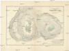
Stereophotogrammetrische Aufnahme des Kraters vom Tangkoeban Prahoe auf Java (Niederl. Jdien)
1 : 2500 Boon Luftbild-Stereographik-Konßortium
[Tjoeroeg] : hermeten in 1917 / Topografische Inrichting
Topografische Inrichting Batavia Batavia : Topografische Inrichting
[Nenggeng] : hermeten in 1910-1912 / Topografische Inrichting
Topografische Inrichting Batavia Batavia : Topografische Inrichting
[Tjiratjas] : hermeten in 1909-1913 / Topografische Inrichting
Topografische Inrichting Batavia Batavia : Topografische Inrichting
[Taringgoeltonggoh] : hermeten in 1909-1912 / Topografische Inrichting
Topografische Inrichting Batavia Batavia : Topografische Inrichting
[Tjiboentoe] : hermeten in 1919 / Topografische Inrichting
Topografische Inrichting Batavia Batavia : Topografische Inrichting
[Gempolsari] : hermeten in 1909-1914 / Topografische Inrichting
Topografische Inrichting Batavia Batavia : Topografische Inrichting
[Djatisari] : hermeten in 1909-1911 / Topografische Inrichting
Topografische Inrichting Batavia Batavia : Topografische Inrichting
[Poerwakarta] : hermeten in 1910-1912 / Topografische Inrichting
Topografische Inrichting Batavia Batavia : Topografische Inrichting
Tjimahi : herzien door den Topografischen Dienst in 1931 / Topografische Dienst
Topografische Dienst Batavia Batavia : Reproductiebedrijf Topografische Dienst
[Kamodjing] : hermeten in 1909-1912 / Topografische Inrichting
Topografische Inrichting Batavia Batavia : Topografische Inrichting
[Tandjoenggaroet] : hermeten in 1912-1913 / Topografische Inrichting
Topografische Inrichting Batavia Batavia : Topografische Inrichting
[Dawoean] : hermeten in 1909-1910 / Topografische Inrichting
Topografische Inrichting Batavia Batavia : Topografische Inrichting
[Doeren] : hermeten in 1908-1913 / Topografische Inrichting
Topografische Inrichting Batavia Batavia : Topografische Inrichting
[Tjidjengkol] : hermeten in 1912-1913 / Topografische Inrichting
Topografische Inrichting Batavia Batavia : Topografische Inrichting
Bandoeng-Noord : herzien door den Topografischen Dienst in 1931 / Topografische Dienst
Topografische Dienst Batavia Batavia : Reproductiebedrijf Topografische Dienst
[Bendoel] : hermeten in 1911-1912 / Topografische Inrichting
Topografische Inrichting Batavia Batavia : Topografische Inrichting


