Maps of Jawa Barat

Overzichtskaart van Java en Madoera / Topografische Dienst
Topografische Dienst Batavia Batavia : Reproductiebedrijf Topografische Dienst
Caart eeniger ryken gelegen op het eyland Groot-Java bestaande in het koningrijk Jaccatra, de Regentschappen Tjandjoer, Bandong, Timbanganten en Batoe Lejan als mede een gedeelte van Parrakkanmoentjang en Crawang
[S.l. : s.n.]
Bandoeng / prepared under the direction of the Chief of Engineers, U.S. Army by the Army Map Service
Army Map Service Washington D.C. Washington D.C. : Army Map Service
Bandoeng / prepared under the direction of the Chief of Engineers, U.S. Army by the Army Map Service
Army Map Service Washington D.C. Washington D.C. : Army Map Service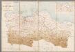
Overzichtskaart van de Residentie Batavia / [Topographische Inrichting]
1 : 250000 Annotatie: Met een overzicht van de bestuurlijke indeling; Kaartrand afgesneden Topographische Inrichting, Nederlands-Indië [Batavia : Topographische Inrichting]
Overzichtskaart van de Residentie Batavia / Topographische Inrichting
Topografische Inrichting Batavia Batavia : Topographische Inrichting
[Purwakarta]
1 : 200000 Joh. C. Stemler Cz.
Cheribon / prepared under the direction of the Chief of Engineers, U.S. Army by the Army Map Service
Army Map Service Washington D.C. Washington D.C. : Army Map Service
[Cimahi]
1 : 200000 Joh. C. Stemler Cz.
[Indramayu]
1 : 200000 Joh. C. Stemler Cz.
Tjitaroemwerken : overzichtskaart / opgemaakt [door] Soekrawinata, Poerwakarta den 300 1930
Poerwakarta : [s.n.]
[Cirebon]
1 : 200000 Joh. C. Stemler Cz.
Pamanoekan- en Tjiasemlanden
[S.l. : s.n.]
Overzichtskaart betreffende den ontworpen spoorweg van Padalarang naar Krawang
[S.l. : s.n.]
Kaart van het Particuliere Land Kandanghauer (Residentie Cheribon, afdeeling Indramajoe)
[S.l. : s.n.]
Goentoer-Papandajan-Tjikoeraj-Galoenggoeg-Telagabodas / Topografische Inrichting, Batavia
Topografische Inrichting Batavia Batavia : Officieële Vereeniging voor Toeristen Verkeer
[Kaart], uit: Goentoer-Papandajan-Tjikoeraj-Galoenggoeg-Telagabodas / Topografische Inrichting, Batavia
1 : 100000 titelvariant: Java, Touristmap Garoet and environs; Touristmap Garoet and environs; Annotatie: Titel op omslag: Java. Touristmap Garoet and environs; Oorspr. uitg.: 1923; Annotatie geografische gegevens: Schaalstok van 10 km (= 10 cm); Legenda Topografische Inrichting, Batavia; Officieële Vereeniging voor Toeristen Verkeer in Nederlandsch Indië, Batavia Batavia : Officieële Vereeniging voor Toeristen Verkeer
Kaart van de Residentie Batavia

[Goenoeng Boekittoenggoel] / Topographisch Bureau, herzien in het jaar 1909
Topographisch Bureau Batavia Batavia : Topografisch Bureau
Hoogvlakte van Bandoeng : autowegenkaart / uitgave HOVIC
[Bandoeng] : HOVIC
Bandoeng / bewerkt door R.W. van Bemmelen
[Batavia : Topografische Dienst]
Poerwakarta / bewerkt door O. Ludwig
[Batavia : Topografische Dienst]
Madjenang / bewerkt door H.W. Hetzel
[Batavia : Topografische Dienst]
Kaart van het terrein bezijden den Grooten Postweg van af Post Toegoe tot Tjiandjoer (Sindanglaja, Tjipanas, Patjet, Mangoenkerta, Tjiandjoer) / Topographisch Bureau Batavia, 1882
Topographisch Bureau Topographisch Bureau Batavia : Topographisch Bureau
Sagalaherang / Direktorat Tata Guna Tanah, Departemen Dalam Negeri
Departemen Dalam Negeri Jakarta . Direktorat Tata Guna Tanah [Jakarta] : Direktorat Tata Guna Tanah, Departemen Dalam Negeri
Cilamaya / Direktorat Tata Guna Tanah, Departemen Dalam Negeri
Departemen Dalam Negeri Jakarta . Direktorat Tata Guna Tanah [Jakarta] : Direktorat Tata Guna Tanah, Departemen Dalam Negeri
Ciasem / Direktorat Tata Guna Tanah, Departemen Dalam Negeri
Departemen Dalam Negeri Jakarta . Direktorat Tata Guna Tanah [Jakarta] : Direktorat Tata Guna Tanah, Departemen Dalam Negeri
Telaga / prepared under the direction of the Chief of Engineers U.S. Army, 1943, copied from a Dutch map dated 1922
Army Map Service U.S. Army Washington D.C. Washington D.C. : Army Map Service
Wandelkaart van Garoet en Omstreken
Weltevreden : Official Tourist Bureau


