Maps of Bangka-Belitung Islands

[G[oenoeng] Pajoeng / opgenomen door den Topografischen Dienst in 1932-1933
Topografische Dienst Batavia Batavia : Reproductiebedrijf Topografische dienst
Topographische kaart van het eiland Billiton : vluchtig opgenomen in de jaren 1877-1878 / Topographisch Bureau
Topographisch Bureau Batavia Batavia : Topographisch Bureau
Geologische kaart van Billiton
1 : 100000 Den Haag : Smulders
Billiton
[S.l. : s.n.]
Manggar / published by War Office = uitgegeven door War Office ; revised and photolithographed by War Office
War Office Washington D.C. [Washington D.C.] : War Office
Kaart van het eiland Billiton / opgenomen en gekaarteerd in de jaren 1877 en 1878 door den Opnemers der Topographische Dienst E. von Hegedus en J.J. van der Rest
Topographische Dienst Batavia [Batavia : Topographische Dienst]
A map of the island of Billiton
1 : 2125000 sketched from description of the native by M. H. Court R. Baily sculpt. London : Black, Kingsbury, Parbury & Allen
Kendawangan / Survey of India
Survey of India [S.l.] : Survey of India
Geologische overzichtskaart van Bangka en Billiton
Amsterdam : Joh. G. Stemler
Pontianak / samengesteld en gedrukt bij den Topografischen Dienst
Topografische Dienst Batavia Batavia : Topografische Dienst
Pontianak / U.S. Army Map Service
U.S. Army Map Service Washington D.C. Washington D.C. : U.S. Army Map Service
Blad VIII Tajan, blad p, uit: Residentie Wester-Afdeeling van Borneo : weg- en rivierkaart / Topographisch Bureau
1 : 50000 Annotatie: Voor aanwezige bladen zie overzichtsblad Topographisch Bureau, Batavia Batavia : Topographisch Bureau
Geologische overzichtskaart van den Nederlandsch Oost-Indischen Archipel : Billiton, Zuidwest-Borneo Blad 1X / bewerkt door L.J.C. van Es Jr
Landsdrukkerij Batavia Weltevreden : Landsdrukkerij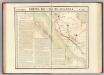
Partie, Sumatra. Oceanique no. 19.
1 : 1641836 Vandermaelen, Philippe, 1795-1869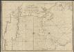
New chart of the straits of Sunda, Banca, Gaspar and Billiton
1 : 110000 drawn from the best authorities, by J. W. Norie, Hydrographer, &c. J. Stephenson, engraver London : Norie
Insulae Iavae Cum parte insularum Borneo Sumatrae, et circumjacentium insularum novissima delineatio. [Karte], in: Novus atlas absolutissimus, Bd. 9, S. 127.
1 Karte aus Atlas Janssonius Offizin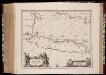
Insulæ Iavæ cum parte insularum Borneo Svmatræ et circumjacentium insularum novissima delineatio
1 : 2500000 Annotatie: Zeekaart; Origineel is Blad 192 in atlas factice; Annotatie geografische gegevens: Schaalstokken op de kaart: 25 Milliaria Germanica Communia (=7,7 cm), en: 35 Milliaria Gallica Communia (=8 cm) Johannes Janssonius 1588-1664 [Amstelodami] : [Apud Ioannem Ianssonium]
Kaart van het eiland Borneo
Grav. en druk van T. Hooiberg te Leiden te 's Hage : uitgave van K. Fuhri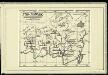
Süd-Borneo

Borneo / Army Map Service, Washington D.C.
Army Map Service Washington D.C. Washington D.C. : Army Map Service
Sumatra : aangevende het aantal inrichtingen voor Inlandsch onderwijs op 31 december 1914
Topographische Inrichting, Batavia Batavia : Top[ographische] Inr[ichting]
Kaart van het eiland Borneo / Topographisch Bureau
Topographisch Bureau Batavia Batavia : Topographisch Bureau
Sumatra : aangevende het aantal inrichtingen voor Inlandsch onderwijs op 31 december 1913 / [Encyclopaedisch Bureau]
Encyclopaedisch Bureau Batavia [Batavia : encyclopaedisch Bureau]
Kaart van Java en Madoera aangevende de spoorweg-, tramweg-, telegraaf- en telefoonverbindingen ... ; Kaart van Java en Madoera aangevende voor elke afdeeling ... de dichtheid der inlandsche bevolking ..., tevens taalkaart ; Geologische overzichtskaart, tevens vulkaankaart van Java en Madoera ; Oro-hydrographische kaart van Java en Madoera / [J.W. Stemfoort en J.J. ten Siethoff]
1 : 2000000 titelvariant: Kaart van Java en Madoera aangevende voor elke afdeeling ... de dichtheid der inlandsche bevolking ..., tevens taalkaart; Geologische overzichtskaart, tevens vulkaankaart van Java en Madoera; Oro-hydrographische kaart van Java en Madoera; Annotatie: Uit: Atlas van Nederlandsch Oost-Indië. - ['s-Gravenhage : Topographische Inrichting], 1898-1907 Stemfoort, J. W.; Siethoff, J. J. ten ['s-Gravenhage : Topographische Inrichting]
Sumatra / [W.A.] Withington
[Lexington (Kentucky)] : [s.n.]
Borneo / Topografische Dienst
Topografische Dienst Batavia Batavia : Reproductiebedrijf Topografische Dienst
Sumatra : aangevende de bestuursindeeling, de standplaatsen der ambtenaren, de dichtheid der bevolking per vierkante KM en de verspreiding der inheemsche bevokingsgroepen / [bewerkt door het Encyclopaedisch Bureau, 1916]
Encyclopaedisch Bureau Batavia [Semarang ; Soerabaja ; 's-Gravenhage : N.V. Boekhandel en Drukkerij v/h G.C.T. van Dorp & Co.]
Het Eiland Sumatra : benevens Bangka, Billiton en Riouw / gelithogr. door E. de Geest
Seyffardt's Boekhandel Amsterdam Amsterdam : Seyffardt's Boekhandel
Sumatra : bevolkingsdichtheid per onderafdeeling volgens uitkomsten der volkstelling in 1930 = density of population per subdivision in 1930
[S.l. : s.n.]
![[G[oenoeng] Pajoeng / opgenomen door den Topografischen Dienst in 1932-1933](https://images-2.georeferencer.com/images/iiif/814121964512/full/,300/0/native.jpg)

