Maps of Lampung

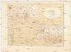
Kroei / [bew. door R.W. van Bemmelen]
Dienst van den Mijnbouw in Nederlandsch-Indië Batavia [Batavia] : Dienst van den Mijnbouw in Nederlandsch-Indië
[Kroë] / opgenomen in 1908-1913 [door den Topographischen Dienst]
Topographische Inrichting Batavia Batavia : Topographische Inrichting
[Oeloemajoes] / opgenomen in 1911-1914 [door den Topographischen Dienst]
Topographische Inrichting Batavia Batavia : Topographische Inrichting
[Antalai] / opgenomen in 1907-1913 [door den Topographischen Dienst]
Topographische Inrichting Batavia Batavia : Topographische Inrichting
[Kota Batoe] / opgenomen in 1909-1916 [door den Topographischen Dienst]
Topographische Inrichting Batavia Batavia : Topographische Inrichting
Atlas behoorende bij het eindverslag over het Geologisch-Mijnbouwkundig Onderzoek in de Residentie Benkoelen
[S.l. : s.n.]
[Ranau-Meer]
Topografische Dienst Batavia Batavia : Reproductiebedrijf Topografische Dienst
Kaart van de voornaamste wegen in het zuidelijk deel der Residentie Palembang
Aardrijkskundig Genootschap Amsterdam Amsterdam : C.L. Brinkman
Kota-Agoeng / published by War Office = uitgegeven door War Office ; revised and photolithographed by War Office
War Office Washington D.C. [Washington D.C.] : War Office
Batoeradja / published by War Office = uitgegeven door War Office ; revised and photolithographed by War Office
War Office Washington D.C. [Washington D.C.] : War Office
Kaart van de afdeeling Boemi Agoeng (Lampongsche Districten) / [overgenomen van een algemeene kaart der Lampongs van] B. Vitzthum von Eckstaedt del. ; J. Postma lith
Aardrijkskundig Genootschap Amsterdam Amsterdam : C.F. Stemler
Batoeradja / Survey of India
Survey of India [S.l.] : Survey of India
Woongebied van den Besemahschen stam
Kaart van Het Gedeelte Java en Sumatra
1 : 500000 Jáva (Indonésie) Eckstein, G. A. Gebroeders Van Cleef
Woongebied van den Besemahschen stam

[Schetskaart van de Residentie Palembang]

Residentie Benkoelen / bewerkt door het Encyclopaedisch Bureau naar gegevens van den Top[ografischen] Dienst en de Marine
Encyclopaedisch Bureau Batavia [Batavia : Javasche Boekhandel & Drukkerij]
[Kaart van Zuid-Sumatra]

[Kaart van Zuid-Sumatra]

Zuid-Sumatra / Voorlichtingsdienst van het Algemeen Landbouw Syndicaat
Voorlichtingsdienst van het Algemeen Landbouw Syndicaat [S.l.] : Voorlichtingsdienst van het Algemeen Landbouw Syndicaat
Kaart aangevende de administratieve indeeling van de residentie Benkoelen
[S.l. : s.n.]
Plan tot den aanleg van spoorwegen in Zuid-Sumatra : overzichtskaart
Ministerie van Koloniën [Den Haag] : [Departement van Koloniën]
Batavia / Survey of India
Survey of India [S.l.] : Survey of India
Batavia / Topografische Inrichting
Topografische Dienst Batavia Batavia : Topografische Inrichting
[Kaart van Straat van Sunda]
[S.l. : s.n.
Sumatra : 1:100.000
[S.l. : s.n.]
Stroomgebieden der Moesi en regenval
[S.l. : s.n.]
8. Zuid-Sumatra, uit: Atlas van Nederlandsch Oost-Indië / samengest. door Topographisch Bureau te Batavia van 1897-1904
Annotatie: Omgewerkte versie van: Atlas der Nederlandsche bezittingen in Oost-Indië / naar de nieuste bronnen samengest. door J.W. Stemfoort en J.J. ten Siethoff. - 's-Gravenhage : Topographische Inrichting, [ca. 1885] Topographisch Bureau, Batavia 's-Gravenhage : Topographische Inrichting
Kaart van Zuid Sumatra : Residentiën Benkoelen, Lampongsche Distrikten en Palembang / [J.W. Stemfoort en J.J. ten Siethoff ; gereproduceerd op last van het Departement van Koloniën, aan de Topographische Inrichting te 's-Gravenhage, onder leiding van den Directeur C.A. Eckstein]
Ministerie van Koloniën Den Haag s-Gravenhage : Departement van Koloniën
![Kroei / [bew. door R.W. van Bemmelen]](https://images-2.georeferencer.com/images/iiif/169908914021/full/,300/0/native.jpg)

