Maps of Bangka-Belitung

Geologische overzichtskaart van Bangka en Billiton
Amsterdam : Joh. G. Stemler
Kaart van den Archipel van Riouw, Singapore en Lingga [and] Kaart van de eilanden Bangka en Blitong
D. Heyse, graveur lith. te 's Hage ; gedr. bij P. Blommers te 's Hage te 's Hage : uitgave van K. Fuhri
Pangkal Pinang / Survey of India
Survey of India [S.l.] : Survey of India
A map of the island of Banca
1 : 200000 by M. H. Court R. Baily sculpt. London : Black, Kingsbury, Parbury & Allen
Schets-taalkaart van de Residentie Bangka / samengesteld door K.F. Holle, Adviseur-Honorair voor Inlandsche Zaken, naar gegevens verstrekt door de ambtenaren van Binnenlandsch Bestuur en met medewerking van het Topographisch Bureau te Batavia
Batavia : Topographisch Bureau
Res[identie] Bangka en Onderh[oorigheden] / Topografische Dienst, Batavia
[S.l. : s.n.]
Geologische kaart van Bangka / naar de opnemingen der mijningenieurs en eigen onderzoekingen samengesteld door R.D.M. Verbeek
Amsterdam : Joh. G. Stemler
Kaart van den Riouw- en Lingga-Archipel / [J.W. Stemfoort en J.J. ten Siethoff ; gereproduceerd op last van het Departement van Koloniën, aan de Topographische Inrichting te 's-Gravenhage, onder leiding van den Directeur C.A. Eckstein]
Ministerie van Koloniën Den Haag s-Gravenhage : Departement van Koloniën
Banka : overzichtskaart der alluviale tinertsafzettingen en van de wegen / aut. C.J. van Doorne
[S.l. : s.n.]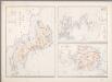
11. [Bangka, Blitoeng, Riouw- en Lingga-Archipel], uit: Atlas van Nederlandsch Oost-Indië / samengest. door Topographisch Bureau te Batavia van 1897-1904
Annotatie: Omgewerkte versie van: Atlas der Nederlandsche bezittingen in Oost-Indië / naar de nieuste bronnen samengest. door J.W. Stemfoort en J.J. ten Siethoff. - 's-Gravenhage : Topographische Inrichting, [ca. 1885] Topographisch Bureau, Batavia 's-Gravenhage : Topographische Inrichting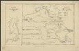
Het eiland Banka, 1819 [and] De rivier van Palembang, 1821
1 : 650000 Amsterdam : Wed. G. Hulst van Keulen
[Bangka]
Topografische Dienst Batavia Batavia : Reproductiebedrijf Topografische Dienst
A map of the island of Billiton
1 : 2125000 sketched from description of the native by M. H. Court R. Baily sculpt. London : Black, Kingsbury, Parbury & Allen
Pangkalpinang / published by War Office = uitgegeven door War Office ; revised and photolithographed by War Office
War Office Washington D.C. [Washington D.C.] : War Office
Overzichtskaart van het wegenstelsel in de Assistent Residentie Belitoeng / Topogr[afische] Inr[ichting]
Topografische Inrichting Batavia Batavia : Topogr[afische] Inr[ichting]
Kaart van het eiland Billiton / opgenomen en gekaarteerd in de jaren 1877 en 1878 door den Opnemers der Topographische Dienst E. von Hegedus en J.J. van der Rest
Topographische Dienst Batavia [Batavia : Topographische Dienst]
Tandjoeng Pandan / published by War Office = uitgegeven door War Office ; revised and photolithographed by War Office
War Office Washington D.C. [Washington D.C.] : War Office
Geologische kaart van de eilanden in de Gaspar-Straten
Amsterdam : Joh. G. Stemler
Topographische kaart van het eiland Billiton : vluchtig opgenomen in de jaren 1877-1878 / Topographisch Bureau
Topographisch Bureau Batavia Batavia : Topographisch Bureau
Manggar / published by War Office = uitgegeven door War Office ; revised and photolithographed by War Office
War Office Washington D.C. [Washington D.C.] : War Office
Geologische kaart van Billiton
1 : 100000 Den Haag : Smulders
[T[andjoen]g Tapah] : opgenomen door den Topografischen Dienst in 1917-1919
Topografische Inrichting Batavia Batavia : Topografische Inrichting
Billiton
[S.l. : s.n.]
Muntok / published by War Office = uitgegeven door War Office ; revised and photolithographed by War Office
War Office Washington D.C. [Washington D.C.] : War Office
Belinjoe / published by War Office = uitgegeven door War Office ; revised and photolithographed by War Office
War Office Washington D.C. [Washington D.C.] : War Office
[Pantjoer Hill] / drawn and reproduced by L.H.Q. Cartographic Co[mpan]y Aust[ralian] Survey Corps
L.H.Q. Cartographic Company Australian Survey Corps [S.l.] : 72 Base Map Rep[roduction] Sec[tion] R.E.
Blad V Karimata, blad a, uit: Residentie Wester-Afdeeling van Borneo : weg- en rivierkaart / Topographisch Bureau
1 : 50000 Annotatie: Voor aanwezige bladen zie overzichtsblad Topographisch Bureau, Batavia Batavia : Topographisch Bureau
[G[oenoeng] Pajoeng / opgenomen door den Topografischen Dienst in 1932-1933
Topografische Dienst Batavia Batavia : Reproductiebedrijf Topografische dienst
[Goemba] / drawn and reproduced by L.H.Q. Cartographic Co[mpan]y Aust[ralian] Survey Corps
L.H.Q. Cartographic Company Australian Survey Corps [S.l.] : 72 Base Map Rep[roduction] Sec[tion] R.E.


