Maps of Halmahera

Lolobata P[oin]t/ prepared under the direction of the Army Engineer, Sixth U.S. Army
War Department Washington D.C. . Corps of Engineers Washington D.C. : War Department
Kaart van het Noorder Schier Eiland van Halemahera / door C.F.H. Campen ; de teekenaar Ch. Martin
Koninklijk Nederlandsch Aardrijkskundig Genootschap Amsterdam [Amsterdam : Stemler]
Voorloopige schetskaart van de eilanden Halmahera en Morotai / [Topographische Inrichting]
[Batavia : Javasche Boekhandel & Drukkerij]
Schetskaart van het Eiland Halmahera en omliggende eilanden / Topographische Inrichting
Topographische Inrichting Batavia Batavia : Topographische Inrichting
Schetskaart van het Eiland Halmahera en omliggende eilanden / Topographische Inrichting
Topographische Inrichting Batavia Batavia : Topographische Inrichting
Bladwijzer van de Afdeeling Ternate
Topografische Inrichting Batavia Bat[avia] : Top[ografische] Inr[ichting]
Halmahera / Topografische Dienst
Topografische Dienst Batavia Batavia : Reproductiebedrijf Topografische Dienst
Bladwijzer van Halmahera schaal 1:100.000 : Ternate en Hiri, Tidore en Maitata en Lolobata, Binau Rivier en Miti Eiland schaal 1:20.000
[S.l. : s.n.]
Halmahera

Ternate / U.S. Army Map Service
U.S. Army Map Service Washington D.C. Washington D.C. : U.S. Army Map Service
Ternate / samengesteld en gedrukt bij den Topografischen Dienst
Topografische Dienst Batavia Batavia : Topografische Dienst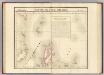
Partie, l'Ile Gilolo. Oceanique no. 15.
1 : 1641836 Vandermaelen, Philippe, 1795-1869
De Molukken of Specerij-Eilanden / gelith. door E. de Geest
Seyffardts Boekhandel Amsterdam Amsterdam : Seyffardts Boekhandel
Kaart der Ternataansche Eilanden / door Js. van den Bosch ; gegraveerd door C. van Baarsel en Zoon
C. van Baarsel en Zoon s-Gravenhage ; Amsterdam : Gebroeders van Cleef
Kaart van de Molukken
D. Heyse, graveur lith. te 's Hage te 's Hage : uitgave van K. Fuhri
Algemeene schetskaart van Nederlandsch-Indië : Gouv[ernement] Groote Oost, Res[identie] Manado / Topografische Dienst, Batavia
[S.l. : s.n.]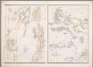
16. [Ambon, Molukken], uit: Atlas van Nederlandsch Oost-Indië / samengest. door Topographisch Bureau te Batavia van 1897-1904
Annotatie: Omgewerkte versie van: Atlas der Nederlandsche bezittingen in Oost-Indië / naar de nieuste bronnen samengest. door J.W. Stemfoort en J.J. ten Siethoff. - 's-Gravenhage : Topographische Inrichting, [ca. 1885] Topographisch Bureau, Batavia 's-Gravenhage : Topographische Inrichting
Geologische schetskaart van het oostelijke gedeelte van den Nederlandsch-Indischen Archipel / door Dr. R.D.M. Verbeek
Topographische Inrichting Batavia [Batavia : Landsdrukkerij]
Carte des iles Moluques
1 : 3425000 par P. Melvill de Carnbee gravé par D. Heyse La Haye : lith de Ch. van Lier
Kaart van het oostelijke gedeelte van den Nederlandsch-Indischen Archipel / Topographische Inrichting
Topographische Inrichting Batavia [Batavia : Landsdrukkerij]
[Borneo, Celebes, Halmaheira, Ceram] / Top. Bureau v/d Gen. Staf
Topographisch Bureau Generale Staf Batavia Batavia : Top. Bureau v/d Gen. Staf
Islas Filipinas, 3a hoja / por el teniente coronel de ingenieros D. Francisco Coello ; las notas estadisticas e historicas han sido escritas por D. Pascual Madoz
1 : 1000000 1 full d'un mapa en tres fulls, b/n. Dins: Atlas de España y sus posesiones de ultramar Coello, Francisco ; Madoz, Pascual [Imprenta del Atlas de España]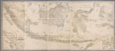
Kaart van Nederlandsch Oost-Indië op een schaal van 1:1.800.000 / naar de nieuwste bronnen bew. onder toezicht van I. Dornseiffen door E. de Geest
1 : 1800000 Annotatie geografische gegevens: Inzet: De Natoena-eilanden; Noordelijk gedeelte der Tidoengsche landen; De Taloer- of Salibao-Eilanden; Atjih, Babi en Nias; Nieuw-Guinea (Nederlandsch gedeelte) en nabijliggende eilanden. - 1:6.000.000 Isaac Dornseiffen 1818-1898; Evert de Geest 1838-? Amsterdam : Seyffardt
Carte des îles Philippines, Célébes et Moluques
1 : 3700000 dressée par M. Daussy d'après les travaux le plus récents gravé par Chassant ; écrit par J.M. Hacq. [Paris] : Dépot-général de la Marine
Blad VII Siding, uit: Residentie Wester-Afdeeling van Borneo / Topographisch Bureau
1 : 200000 titelvariant: Residentie Westerafdeeling van Borneo; Annotatie: Titelvariant: Residentie Westerafdeeling van Borneo; Voor aanwezige bladen zie overzichtsblad; Annotatie geografische gegevens: Opname: 1886-1895 Topographisch Bureau, Batavia Batavia : Topographisch Bureau
Indonesia
IPPRESS Djakarta [Djakarta] : IPPRESS
La presqu'isle de l'Indie au dela du Gange, avec l'archipel des Indes
1 : 12640000 Asie jihovýchodní Bonne, Rigobert André
Bladwijzer van de Asia-Serie
[S.l.] : [Survey of India]
Indonesië : voorlopige staatkundige ordening, bijgewerkt tot 1 october 1949
[S.l. : s.n.]
![Lolobata P[oin]t/ prepared under the direction of the Army Engineer, Sixth U.S. Army](https://images-2.georeferencer.com/images/iiif/141393794805/full/,300/0/native.jpg)

