Maps of Jawa Tengah

Semarang / Survey of India
Survey of India [S.l.] : Survey of India
Overzicht Wegennet Midden-Java : afstandskaart / getekend door C.J. Schalks, 26-06-[19]47
Semarang : O.I.D.
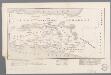
4. Midden Java, uit: Atlas van Nederlandsch Oost-Indië / samengest. door Topographisch Bureau te Batavia van 1897-1904
Annotatie: Omgewerkte versie van: Atlas der Nederlandsche bezittingen in Oost-Indië / naar de nieuste bronnen samengest. door J.W. Stemfoort en J.J. ten Siethoff. - 's-Gravenhage : Topographische Inrichting, [ca. 1885] Topographisch Bureau, Batavia 's-Gravenhage : Topographische Inrichting
Kaart van een gedeelte van het Eiland Java : uitgemaakt hebbende het tooneel van den oorlog van 1825-1830 / door L.M. Lange. Majoor bij het Nederl[andsch] Ind[isch] Leger, Ridder der Militaire Willems Orde ; geteekend en op 61/4 verkleind door H. Hama, Gead. Landmeter
[Zendingskaart van Midden-Java]
1 : 750000 Annotatie: Uit: Sadrach's kring / L. Adriaanse. - Leiden : Donner, 1899 [Leiden : Donner]
Westelijk-gedeelte van het oorlogstooneel van den Java-Oorlog 1825-1830 / ontworpen door den Kapitein der Infanterie P.J.F. Louw
[Batavia : Landsdrukkerij]
Semarang-Cheribon : overzichtskaart / Semarang Cheribon Stoomtram Maatschappij
Semarang Cheribo Stoomtram-Maatschappij Semarang [Semarang] : Stoomtram-Maatschappij
Irrigatie-Afdeeling Serang : (bedoeld wordt Semarang)

Kaart tot afstandswijzer van de residentie Banjoemas
[S.l. : s.n.]
Algemene overzichtskaart / Serajoedal Stoomtrammaatschappij
Rijswijk : Broek en van Gheel Gildemeester
Kaart van de Residentie Samarang = Gambaripoen siti ing Karesidenan Samarang / door H.Ph.Th. Witkamp = jasanipoen toewan H.Ph.Th. Witkamp ; Abdullah Mohamed Hamerodin del. ; R. Roobol en L.G. Kierdorff grav[ure], Maart 1886
Koninklijk Nederlandsch Aardrijkskundig Genootschap Amsterdam Leiden : E.J. Brill
Serajoedal Stoomtrammaatschappij algemeene overzichtskaart / Serajoedal Stoomtrammaatschappij, mei 1912
[S.l.] : Serajoedal Stoomtrammaatschappij
Overzichtskaart van de Residentie Semarang / Topographische Inrichting
Topografische Inrichting Batavia Batavia : Topographische Inrichting
Pekalongan / prepared under the direction of the Chief of Engineers, U.S. Army by the Army Map Service
Army Map Service Washington D.C. Washington D.C. : Army Map Service
Overzichtskaart van de Residentie Banjoemas / Topographische Inrichting
Topographische Inrichting Batavia Batavia : Topographische Inrichting
Kaart van den spoorweg van Samarang naar de Vorstenlanden
Lang, Carl Semarang Samarang : [s.n.]
Bandjar / prepared under the direction of the Chief of Engineers, U.S. Army by the Army Map Service
Army Map Service Washington D.C. Washington D.C. : Army Map Service
Cheribon / prepared under the direction of the Chief of Engineers, U.S. Army by the Army Map Service
Army Map Service Washington D.C. Washington D.C. : Army Map Service
[Jepara]
1 : 200000 Joh. C. Stemler Cz.
Bandjar / prepared under the direction of the Chief of Engineers, U.S. Army by the Army Map Service
Army Map Service Washington D.C. Washington D.C. : Army Map Service
[Pekalongan]
1 : 200000 Joh. C. Stemler Cz.
[Semarang]
1 : 200000 Joh. C. Stemler Cz.
Overzichtskaart van de residentie Kÿæedoe / Topografische Inrichting
Topografische Inrichting Batavia Batavia : Topografische Inrichting
[Lak Bondo] : hermeten in 1910-1911 / Topografische Inrichting
Topografische Inrichting Batavia Batavia : Topografische Inrichting
[Cirebon]
1 : 200000 Joh. C. Stemler Cz.
Spoorweg Samarang-Vorstenlanden
s Hage : Smulders & Cÿê.
[Indramayu]
1 : 200000 Joh. C. Stemler Cz.
Afstandwijzer en kaart der Residentie Kadoe
[S.l. : s.n.]
Midden-Java = Middle Java / Reproductiebedrijf Top[ografische] Dienst, Batavia
Topografische Dienst Batavia Batavia : Officieële Vereeniging voor Toeristenverkeer in Nederlandsch Indië


