Maps of Christiansted
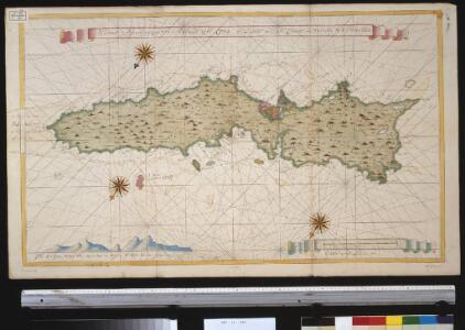
Nieuwe afteekening van t eijland St. Cruz of l'Isle de St. Croix in Westindia bij I. Porto Rico
Virgin Islands Gerard van Keulen
Christiansted
1 : 24000
Christiansted
1 : 24000
Christiansted
1 : 24000
Christiansted
1 : 24000
Christiansted
1 : 24000
Christiansted
1 : 24000
East Point
1 : 24000
East Point
1 : 24000
East Point
1 : 24000
East Point
1 : 24000
East Point
1 : 24000
Frederiksted
1 : 24000
Frederiksted
1 : 24000
Frederiksted
1 : 24000
Frederiksted
1 : 24000
St. Thomas, St. Jan, St. Crook.
1 : 206000 Peterson, Augusts
Dutch Possessions in South America and the West Indies.
1 : 2407680 Fullarton, A. & Co.
Supplement pour les Isles Antilles, extrait des carte Angloises
1 : 1300000
Porto Rico.
1 : 507000 Rand McNally and Company
Porto Rico, Virgin Isles, Hispaniola.
1 : 700000 Thomson, John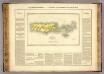
Porto Rico, Iles Vierges.
1 : 1100000 Buchon, J. A. C.; Carey, H. C.; Lea, I.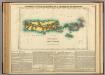
Map Of Porto Rico And The Virgin Islands.
1 : 950400 Lea, I.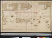
Afteekening van het eijland St. Juan de Porto Rico
Puerto Rico Gerard van Keulen
Map of The Leeward Islands.
1 : 950400 Arrowsmith, John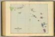
Leeward Islands.
1 : 887040 Stanford, Edward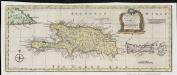
A new & accurate map of the islands of Hispaniola or St. Domingo, and Porto Rico
1 : 2750000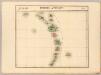
Petites Antilles. Amer. Sep. 75.
1 : 1641836 Vandermaelen, Philippe, 1795-1869
The Caribbee Islands, the Virgin Islands, and the Isle of Porto Rico.
1 : 1560000 Jefferys, Thomas