Maps of North Atlantic Ocean
Nieuwe platte paskaert strekkende van IJsland tot de Straet seer dienstigh voor die gene die agterom zijlen
Europe Gerard van Keulen
Carte generale de toute l'Europe, 1
2 Blätter : 109 x 47 cm J.M. Will
Carte générale de toute l'Europe, 1
2 Blätter : 109 x 50 cm T.C. Lotter
L'ocean pres d'Europe
1 Karte : Kupferdruck ; 46 x 34 cm Duval chez l'auteur
England, Scotland & Ireland, with the iles thereto belonging.
from A new systeme of the mathematicks: containing I. Arithmetick, as well natural and decimal, as in species, or the principles of algebra. II. Practical geometry, together with the first six books of Euclid's Elements, as also the eleventh and twelfth, symbo
Carte des costes maritimes de l'Europe
1 Karte : Kupferdruck ; 64 x 48 cm Nolin; Basset; Basset chez Basset rue St. Jacques
Carte des costes maritimes de l'Europe
1 Karte : Kupferdruck ; 64 x 48 cm Nolin; Daumont chez Daumont rue de la Feronnerie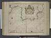
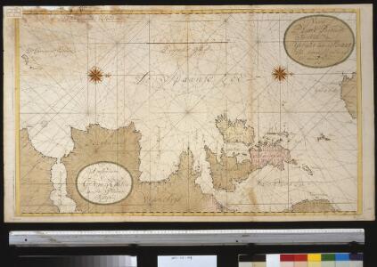
Paskaert van Spanjen, vertoonende de Kusten van Granade, Andaluzie, Algarve, Portugael, Galissen en Biscajen, met een gedeelte van Vranckrijck streckende van Heyssant tot de Straet van Gibralter.
from De zee-atlas ofte water-wereld : waer in vertoont werden alle de zee-kusten van het bekende des aerd-bodems : seer dienstigh voor alle heeren en kooplieden, als oock voor alle schippers en stuurlieden / by Pieter Goos.
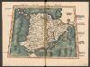
Spain.
from Abraham Ortelius his epitome of the theater of the worlde / nowe latlye ... renewed and augmented ... by Micheal Coignet, mathematitian of Antwarpe.
Carte pour resoudre les six problemes 1749
1 : 15000000 Mollova mapová sbírka
Carte pour resoudre les six problemes
1 Karte : Kupferdruck ; 17 x 13 cm, Bildgrösse 22 x 34 cm Königliche Akademie der Wissenschaften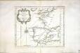
Carte des costes de France et d'Espagne
1 Karte : Kupferdruck ; 21 x 26 cm Bellin Arkstée et Merkus
Pas-Caart van Hispaengien vertoonende Custen van Granade, Andaluzie, Algarve Portugael, Galissen, en Biscajen [...] [Karte], in: De Nieuwe Groote Vermeerderde Zee-Atlas ofte Water-Werelt, S. 49.
1 Karte aus Atlas Doncker, Hendrick
Nieuwe pas-caart; vertoonende, hoemen uyt de canaal, de custen van Portugael, Barbarijen, de Canarische en Vlaemsche eylanden beseylen zal
1 Karte : Kupferdruck ; 42 x 54 cm Doncker by Hendrick Doncker boekverkoper inde Nieubrugsteech in 't Stuurmans gereetschap
Tabula Europae II. [Karte], in: Claud. Ptolemaeus. Geographia lat. cum mappis [...], S. 257.
1 Karte aus Atlas Münster, Sebastian [und Ptolemaeus, Claudius]
Tabula Nova Hibernie Anglie Et Scotie [Karte], in: Claudii Ptolemei viri Alexandrini mathematice discipline philosophi doctissimi geographie opus [...], S. 236.
1 Karte aus Atlas Waldseemüller, Martin [und Ptolemaeus, Claudius] Übelin, Georg
Germanie, France, Italie, Espagne, Isles Britanniques.
1 : 5200000 Anville, Jean Baptiste Bourguignon d, 1697-1782
Western Europe.
1 : 6900000 Goodrich, S.G.

Tabula Europae II. [Karte], in: Geographia universalis vetus et nova complectens Claudii Ptolemaei Alexandrini enarrationis libros VIII, S. 225.
1 Karte aus Atlas Münster, Sebastian [und Ptolemaeus, Claudius]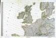
Carte d'Europe ou sont tracées les limites des empires, royaumes, et etats souverains, feuille 3
1 Blatt : 65 x 95 cm Semen etc
The seat of war on the coast of France being a new chart of the coast of Holland, Flanders, France, Spain & Portugal, with the adjacent islands, part of Barbary, England and Ireland
Anglie Bowen, Emanuel T. Jefferys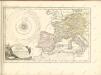

Carte generale de toute l'Europe, 1
1 Blatt : 57 x 48 cm J.M. Will
[Jihozápadní Evropa]
1 : 5800000 Evropa jihozápadní
Die Britischen Inseln
[Allgemeiner Atlas über alle Theile der Erde in 29 Blättern] Ziegler, Jakob Melchior Top. Anstalt v. J. Wurster u. Comp.
Grossbritanien und Ireland
Neuester Schul-Atlas Walch, Johann im Verlag bei Joh. Walch
Prima Europe Tabula [Karte], in: [Clavdii Ptholomei Cosmographi ...], S. 245.
1 Karte aus Atlas Nicolaus Germanus [und Ptolemaeus, Claudius]
Tabula Europae I. [Karte], in: Claud. Ptolemaeus. Geographia lat. cum mappis [...], S. 254.
1 Karte aus Atlas Münster, Sebastian [und Ptolemaeus, Claudius]