Maps of Porto Tolle
Monding van de Po
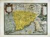
Italy Gerard van Keulen
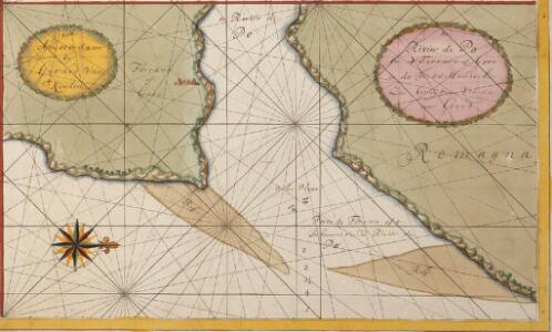
Nieuwe afteekening van alle de de inkoomende rieviere die inde rivier de Po loopen is geleegen agter in de Golf van Venetia, aen de West zijde
Italy Gerard van Keulen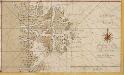
Afteekening van alle de incoomende riviere die in de Po loopen
Italy Gerard van Keulen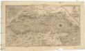
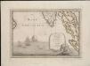
Golfo di Venetia
1 : 2830000 Benátky-oblast (Itálie) Forlani, Paolo Badoero, Piero Paolo Forlani
Mappa del Padovano del Polesine di Rovigo del Dogado della parte meridionale del Vicento del Trevigiano e della parte settentrionale del Ferrarese
1 : 145000 Benátsko (Itálie) Valle, Giovanni Viani, Mattio Mattio Viani
Dvcato di Ferrara
1 : 320000 Ferrara (Itálie) Janssonius, Johannes sumptibus Ioannis Iassonii
Dvcato di Ferrara
1 : 320000 Ferrara (Itálie) Poirson, J. B. Janssonius, Johannes sumptibus Ioannis Ianßonii
Carte nouvelle du Padouan, et le Polsin de Rovigo, de la République de Venise : levée par ordre exprès à l'usage des armées en Italie, où sont exactement marqués les grands chemins, les routes des imperiaux &c
1 : 220000 par le Sr. Sanson A Amsterdam : chez Pierre Mortier
Territorio Padouano [Karte], in: Le théâtre du monde, ou, Nouvel atlas contenant les chartes et descriptions de tous les païs de la terre, Bd. 3, S. 123.
1 Karte aus Atlas Blaeu, Willem Janszoon und Blaeu, Joan Blaeu, Willem Janszoon
Territorio Padovano [Karte], in: Theatrum orbis terrarum, sive, Atlas novus, Bd. 3, S. 107.
1 Karte aus Atlas Blaeu, Joan Blaeu, Willem Janszoon
Territorio Padovano [Karte], in: Novus Atlas, das ist, Weltbeschreibung, Bd. 3, S. 127.
1 Karte aus Atlas Blaeu, Joan Blaeu, Willem Janszoon

Territorio Padovano. [Karte], in: Novus atlas absolutissimus, Bd. 5, S. 47.
1 Karte aus Atlas Janssonius Offizin
DVCATO | DI | FERRARA
[Amsterdam : Joan Blaeu]
Territorio Padovano. [Karte], in: Gerardi Mercatoris et I. Hondii Newer Atlas, oder, Grosses Weltbuch, Bd. 2, S. 255.
1 Karte aus Atlas Mercator, Gerhard und Hondius, Jodocus Jansson, Jan
Ducato Di Ferrara [Karte], in: Le théâtre du monde, ou, Nouvel atlas contenant les chartes et descriptions de tous les païs de la terre, Bd. 3, S. 186.
1 Karte aus Atlas Blaeu, Willem Janszoon und Blaeu, Joan Blaeu, Willem Janszoon
Ducato Di Ferrara [Karte], in: Theatrum orbis terrarum, sive, Atlas novus, Bd. 3, S. 144.
1 Karte aus Atlas Blaeu, Joan Blaeu, Willem Janszoon
Ducato Di Ferrara [Karte], in: Novus Atlas, das ist, Weltbeschreibung, Bd. 3, S. 164.
1 Karte aus Atlas Blaeu, Joan Blaeu, Willem Janszoon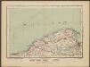
Carte Nouvelle du Padouana, et le Polsin de Ruvigo, de la Republique de Venise [...] [Karte], in: Atlas nouveau, contenant toutes les parties du monde [...], Bd. 2, S. 160.
1 Karte aus Atlas Sanson, Nicolas Jaillot, Alexis Hubert und Mortier, Pieter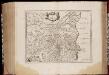
Dvcato di Ferrara
1 : 330000 Annotatie: Origineel is Blad 160 in atlas factice; Annotatie geografische gegevens: Schaalstokken op de kaart: 8 Milliaria Italica (=4,5 cm), en: 2 Milliaria Germanica (=4,5 cm) Amstelodami : sumptibus Ioannis Ianssonii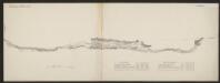
Ducato Di Ferrara [Karte], in: Gerardi Mercatoris et I. Hondii Newer Atlas, oder, Grosses Weltbuch, Bd. 2, S. 302.
1 Karte aus Atlas Mercator, Gerhard und Hondius, Jodocus Jansson, Jan
Ducato Di Ferrara. [Karte], in: Novus atlas absolutissimus, Bd. 5, S. 149.
1 Karte aus Atlas Janssonius Offizin
Carta Generale del Regno Lombardo-Veneto e paesi limitrofi... IV.


[Venetien]
1 : 3000000 Venetien Einigungskriege
Veronae Vicentiae Et Patavii Ditiones [Karte], in: Gerardi Mercatoris Atlas, sive, Cosmographicae meditationes de fabrica mundi et fabricati figura, S. 447.
1 Karte aus Atlas Mercator, Gerhard Montanus, Petrus
Lo Stato Veneto da terra diviso nelle sue provincie, quarta parte che compren de porzioni del Dogado e dell' Istria.
1 : 536000
Fori Ivlii accvrata descriptio
1 Karte : Kupferdruck ; 34 x 46 cm Sambucus; Ortelius s.n.