Maps of Cayeux-sur-Mer
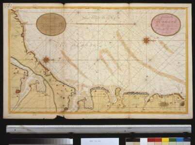
Een gedeelte van het Kanaal van Boulogne tot aen Sotteville int groodt
France Gerard van Keulen
Les costes du Boulenois et de la Picardie
1 : 110000 Boulogne-sur-Mer (Francie) Fricx, Eugene Henry Harrewyn, Jacques chez Eugene Henry Fricx
[Dieppe]
1 Blatt : 60 x 91 cm s.n.
Sheet 9. (Cary's England, Wales, and Scotland).
1 : 360000 Cary, John, ca. 1754-1835
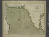
Les capitaineries garde-costes de St. Valery, Cayeu, Treport, Cryelle, Val de Conte, Dieppe, de la Chapelle S.te Marguerite, de la vallée de Senne, et celle du Crotoy
1 Karte : 22 x 33 cm de Fer
Les embouchures de la Somme et de Bresle Riv., où est St. Valeri, Eu et Dieppe
1 : 120000 J. Harrewyn f[ecit] Bruxelles : chez Eugene Henry Fricx
Les Embouchures de la Somme et de Bresle Riv: où est S. Valeri, Eu et Dieppe
1 : 116600 Mollova mapová sbírka Fricx, Eugène Henry Harrewyn, Jacques Fricx, Eugené Henry
Les embouchures de la Somme et de Bresle riv. ou est St. Valeri, Eu et Dieppe
1 : 110000 Dieppe (Francie) Fricx, Eugene Henry Harrewyn, Jacques chez Eugene Henry Fricx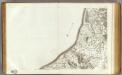
23 Dieppe.
1 : 86400 Cassini family; Cassini, Cesar-Francois, 1714-1784
Les Embouchures de la Somme et de Bresle Riv. ou est St. Valeri, Eu et Dieppe
1 : 116600 Mollova mapová sbírka Fricx, Eugène Henry Covens, Johannes I
No. 22 [Boulogne], uit: Carte géométrique de la France dite "Carte de Cassini" ou "de l'Académie"
1 : 86400 titelvariant: Carte de Cassini; Annotatie: Incompleet; Voor aanwezige bladen zie overzichtsblad Cassini de Thury, C.-F. Paris : [s.n.]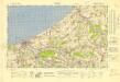
France 1:50,000 , Series GSGS 4250, Dieppe
France 1:50,000 , Series GSGS 4250. Great Britain. War Office. General Staff. Geographical Section. [London] : Ordnance Survey
22 Boulogne.
1 : 86400 Cassini family; Cassini, Cesar-Francois, 1714-1784
[Boulogne]
1 Blatt : 60 x 47 cm Le Roy s.n.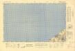
France 1:50,000 , Series GSGS 4250, Eu
France 1:50,000 , Series GSGS 4250. Great Britain. War Office. General Staff. Geographical Section. [London] : Ordnance Survey
Les Costes du Boulenois et de la Picardie
1 : 116600 Mollova mapová sbírka Fricx, Eugène Henry Harrewyn, Jacques Fricx, Eugené Henry
Le Canal et Partie dela France
1 : 116600 Mollova mapová sbírka Fricx, Eugène Henry Covens, Johannes I
Carte Contenant le Pais entre Boulogne, Aire, Amiens, et Dieppe
1 : 200000 Mollova mapová sbírka Le Rouge, Georges-Louis Le Rouge, Georges-Louis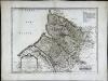
Britanni
1 Karte : Kupferdruck ; 38 x 50 cm Sanson; Robert de Vaugondy; Cordier ches le S. Robert geogr. ord. du r. quai de l'Horloge du Palais
Ponthiev comitatvs
1 Karte : Kupferdruck ; 14 x 19 cm Lambert Andreae
Carte particuliere du diocese de Rouen, 2
1 Blatt : Dezauche
France and Belgium 1:50,000, Boulogne
This topographic sheet, France and Belgium 1:50 000, Series GSGS 4040 [Defences], contains standard topographic informaation including contours. Great Britain. Army. Royal Engineers. Map Reproduction Section, 18th. [S.l.] : [s.n.]
3) II.O. ''Boulogne'', uit: Carte géologique de France
1 : 500000 Annotatie: Voor aanwezige bladen zie bladoverzicht [S.l : s.n.]
The sea-coasts of FRANCE from Calais to the River Seine
from The sea-atlas : containing an hydrographical description of most of the sea-coasts of the known parts of the world.
Le Gouvernement General De Picardie, ou sont Le Pays Reconquis, Le Boulenois, Le Ponthieu [...] [Karte], in: Atlas nouveau, contenant toutes les parties du monde [...], Bd. 1, S. 112.
1 Karte aus Atlas Sanson, Nicolas Jaillot, Alexis Hubert und Mortier, Pieter
Carte des départemens du Pas de Calais, de la Somme, de l'Oise et de l'Aisne
1 Karte : Kupferdruck ; 23 x 34 cm, Bildgrösse 31 x 42 cm Desnos; Starckman chés Desnos ing.r géogaphe pour les globes et sphères rue St. Jacques au globe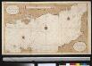
Het oostelijkste gedeelte vant Kanaal vertoonende de kust van Engeland van Dover tot Portland
England Gerard van Keulen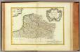
Flandre francoise, Artois, Picardie, Boulenois.
1 : 930000 Bonne, Rigobert, 1727-1794