Maps of Wanze

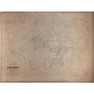
Plan parcellaire de la commune de Vinalmont : avec les mutations
1 : 5000 Royal Library of Belgium Map Room Popp, Philippe Christian (1805-1879) Popp, Philippe Christian (1805-1879)
Plan parcellaire de la commune de Warnant-Dreye : avec les mutations
1 : 5000 Royal Library of Belgium Map Room Popp, Philippe Christian (1805-1879) Popp, Philippe Christian (1805-1879)
Plan parcellaire de la commune de Antheit : avec les mutations
1 : 5000 Royal Library of Belgium Map Room Popp, Philippe Christian (1805-1879) Popp, Philippe Christian (1805-1879)
Plan parcellaire de la commune de Villers-le-Bouillet : avec les mutations
1 : 5000 Royal Library of Belgium Map Room Popp, Philippe Christian (1805-1879) Popp, Philippe Christian (1805-1879)
Plan parcellaire de la commune de Fumal : avec les mutations
1 : 5000 Royal Library of Belgium Map Room Popp, Philippe Christian (1805-1879) Popp, Philippe Christian (1805-1879)
Plan parcellaire de la commune de Wanze : avec les mutations
1 : 5000 Royal Library of Belgium Map Room Popp, Philippe Christian (1805-1879) Popp, Philippe Christian (1805-1879)
Plan parcellaire de la commune de Moha : avec les mutations
1 : 5000 Royal Library of Belgium Map Room Popp, Philippe Christian (1805-1879) Popp, Philippe Christian (1805-1879)
Plan parcellaire de la commune de Huccorgne : avec les mutations
1 : 5000 Royal Library of Belgium Map Room Popp, Philippe Christian (1805-1879) Popp, Philippe Christian (1805-1879)
Plan parcellaire de la commune de Ampsin : avec les mutations
1 : 5000 Royal Library of Belgium Map Room Popp, Philippe Christian (1805-1879) Popp, Philippe Christian (1805-1879)
Plan parcellaire de la commune de Fize-Fontaine : avec les mutations
1 : 5000 Royal Library of Belgium Map Room Popp, Philippe Christian (1805-1879) Popp, Philippe Christian (1805-1879)
Huy mit der gegend auff 2 Stunden.
1 : 150000 Mollova mapová sbírka Bodenehr, Gabriel Bodenehr, Gabriel
Comté de Namur
1 : 116600 Mollova mapová sbírka Fricx, Eugène Henry Covens, Johannes I
Carte particuliere des environs de Namur, Huy, Dinant, Philippeville, etc.
1 : 116600 Mollova mapová sbírka Fricx, Eugène Henry Harrewyn, Jacques Fricx, Eugené Henry
[Carte particuliere des environs de Namur, Huy, Dinant, Philippeville, etc.]
Belgie Fricx, Eugene Henry chez Eugene Henry Fricx
Comté de Namur
1 : 115000 A Amsterdam : chez Cóvens et Mortier

Prima Pars Brabantiae cuius caput Lovanium [Karte], in: Novus Atlas, das ist, Weltbeschreibung, Bd. 1, S. 313.
1 Karte aus Atlas Blaeu, Joan Blaeu, Willem Janszoon
Prima Pars Brabantiae cuius caput Lovanium [Karte], in: Novus atlas absolutissimus, Bd. 3, S. 42.
1 Karte aus Atlas Janssonius Offizin
Lovaniensis Tetrarchia
1 : 133000 Mollova mapová sbírka Visscher, Nicolaes Jansz. Schenk, Peter II
Prima Pars Brabantiae cuius caput Lovanium [Karte], in: Theatrum orbis terrarum, sive, Atlas novus, Bd. 1, S. 335.
1 Karte aus Atlas Blaeu, Joan Blaeu, Willem Janszoon
Lovaniensis tetrarchia una cum Arscotano ducatu in eiusdem ditiones subiacentes accuratissime divisa
1 : 176000 Aarschot (Belgie) Visscher, Nicolaes Jansz. Schenk, Pieter apud Petrum Schenk iunior
XIV ; 3.L., uit: Carte chorographique des Pays-Bas Autrichiens / ... par le Comte de Ferraris ; gravée par L.A. Dupuis
1 : 86400 Annotatie: Bladen linksboven genummerd met Romeinse cijfers, rechtsboven met een cijfer en een letter; Met opdracht aan keizer Joseph II (bl.XVI); Met plattegrond van Brussel (bl. XXI), overzichtskaart (bl. XXII) en bladwijzer (bl. XXIII); Annotatie geografische gegevens: Schaalstokken: Echelle de Toises ou de Lieues communes de France; Echelle de Verges ou de Lieues de Brabant; Echelle de Milles d'Allemagne (bl. XVII); Echelle de Mètres; In de hoeken lengte- en breedtematen T.M.e en T.P.e Joseph-Jean François Ferraris Comte de 1726-1814; L.A. Dupuis [S.l. : s.n.]
NAMVRCVM | COMITATVS
Auctore Iohann. Surhonio. [Amsterdam : Joan Blaeu]
Namurcum Comitatus. [Karte], in: Theatrum orbis terrarum, S. 111.
1 Karte aus Atlas Ortelius, Abraham

[Kaart], uit: Carte routière des environs de Namur
1 : 160000 Bruxelles : De Boeck
Namurcum Comitatus 1632 [Karte], in: Gerardi Mercatoris et I. Hondii Newer Atlas, oder, Grosses Weltbuch, Bd. 1, S. 434.
1 Karte aus Atlas Mercator, Gerhard und Hondius, Jodocus Jansson, Jan
NAMVRCVM | COMITATVS
Auctore Iohann. Surhonio. [Amsterdam : Joan Blaeu]
Namurcum Comitatus. [Karte], in: Theatrum orbis terrarum, S. 177.
1 Karte aus Atlas Ortelius, Abraham Vrients, Jan Baptista