Maps of Slenaken

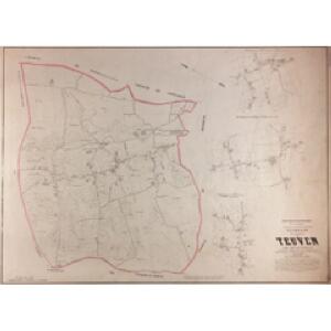
Plan parcellaire de la commune de Teuven : avec les mutations
1 : 5000 Royal Library of Belgium Map Room Popp, Philippe Christian (1805-1879) Popp, Philippe Christian (1805-1879)
Plan parcellaire de la commune de Remersdael : avec les mutations
1 : 5000 Royal Library of Belgium Map Room Popp, Philippe Christian (1805-1879) Popp, Philippe Christian (1805-1879)
Meßtischblatt3028. 3029 : Aachen, 1925
1 : 250000 Aachen. - Aufn. 1893, Nachtr. 1923, bericht. 1925. - 1:25000. - [Berlin]: Reichsamt für Landesaufnahme, 1925. - 1 Kt.
Meßtischblatt 3028. 3029 : Aachen, 1895
1 : 250000 Aachen. - Aufn. 1893. - 1:25000. - [Berlin]: Kgl. Preuss. Landesaufnahme, 1895. - 1 Kt.
Plan parcellaire de la commune de Fouron-Saint-Martin : avec les mutations
1 : 5000 Royal Library of Belgium Map Room Popp, Philippe Christian (1805-1879) Popp, Philippe Christian (1805-1879)
Plan parcellaire de la commune de Sippenaeken : avec les mutations
1 : 5000 Royal Library of Belgium Map Room Popp, Philippe Christian (1805-1879) Popp, Philippe Christian (1805-1879)
Carte particuliere des environs de Fauquemont et Aix-la Chapelle
1 : 163000 Cáchy (Německo) Covens & Mortier
62 Heerlen, uit: Topographische en militaire kaart van het Koningrijk der Nederlanden / vervaardigd door de officieren van den Generale Staf ; en gegraveerd op het Topographisch Bureau, van het Ministerie van Oorlog
1 : 50000 titelvariant: TMK; Annotatie: Met bladwijzer op schaal 1:600.000. - 1915; Met Verklaring van de topographische en militaire kaart van het Koninkrijk der Nederlanden. - 1910; Bd. 1: titelblad, bladwijzer, verklaring, bladen 1 t/m 32; Bd. 2: bladen 33 t/m 62 Generale Staf, Nederland; Ministerie van Oorlog. Topographisch Bureau ['s-Gravenhage : Ministerie van Oorlog]

Bijlage 23, uit: Eindverslag over de onderzoekingen en uitkomsten van den Dienst der Rijksopsporing van Delfstoffen in Nederland, 1903-1916
Annotatie: Met lit. opg Departement van Landbouw, Nijverheid en Handel. Dienst der Rijksopsporing van Delfstoffen ['s-Gravenhage : Martinus Nijhoff]
Bijlage 34, uit: Eindverslag over de onderzoekingen en uitkomsten van den Dienst der Rijksopsporing van Delfstoffen in Nederland, 1903-1916
Annotatie: Met lit. opg Departement van Landbouw, Nijverheid en Handel. Dienst der Rijksopsporing van Delfstoffen ['s-Gravenhage : Martinus Nijhoff]
Bl. 35 Maastricht, 1917, uit: Atlas A.N.W.B.
1 : 200000 titelvariant: Atlas van Nederland van den A.N.W.B. Toeristenbond voor Nederland; Wielrijders-atlas van Nederland; Annotatie: Titel op bladwijzer: Atlas van Nederland van den A.N.W.B. Toeristenbond voor Nederland; Titel op legendablad: Wielrijders-atlas van Nederland; Voor aanwezige bladen zie overzichtsblad; Annotatie geografische gegevens: De serie bestaat uit 36 bladen ANWB ['s-Gravenhage : A.N.W.B.]
Bl. 35 Maastricht, 1920, uit: Atlas A.N.W.B.
1 : 200000 titelvariant: Atlas van Nederland van den A.N.W.B. Toeristenbond voor Nederland; Wielrijders-atlas van Nederland; Annotatie: Titel op bladwijzer: Atlas van Nederland van den A.N.W.B. Toeristenbond voor Nederland; Titel op legendablad: Wielrijders-atlas van Nederland; Voor aanwezige bladen zie overzichtsblad; Annotatie geografische gegevens: De serie bestaat uit 36 bladen ANWB ['s-Gravenhage : A.N.W.B.]
Tabula ducatus Limburch et comitatus Valckenburch
1 : 115000 Limbursko Wit, Frederick de by Frederick de Wit
Nieuwe en naauwkeurige kaart van de drie landen van Overmaaze, Valkenburg, Daalhem en 's Hertogenrade
1 : 200000 J. Keyser schulp. 1739. te Amsterdam : by Isaak Tirion
Carte particuliere des environs de Maestricht, partie de Liege, Faucquemont, et Pays d'Outre-Meuse
1 : 110000 Belgie Fricx, Eugene Henry Harrewyn, Jacques chez Eugene Henry Fricx
Bl. 35 Maastricht, 1904, uit: Atlas A.N.W.B.
1 : 200000 titelvariant: Atlas van Nederland van den A.N.W.B. Toeristenbond voor Nederland; Wielrijders-atlas van Nederland; Annotatie: Titel op bladwijzer: Atlas van Nederland van den A.N.W.B. Toeristenbond voor Nederland; Titel op legendablad: Wielrijders-atlas van Nederland; Voor aanwezige bladen zie overzichtsblad; Annotatie geografische gegevens: De serie bestaat uit 36 bladen ANWB ['s-Gravenhage : A.N.W.B.]
Carte du Marquisat de Franchimont
1 : 140000 H. Godin sculp. [S.l.] : [s.n.]
Carte Particuliere des environs de Maestricht Partie de Liege, Faucquemont, et Pays d'Outre-Meuse
1 : 116600 Mollova mapová sbírka Fricx, Eugène Henry Harrewyn, Jacques Fricx, Eugené Henry
Limburgi Ducatus et Comitatus Valckenburgi Nova Descriptio
1 : 110000 Mollova mapová sbírka Visscher, Nicolaes Schenk, Peter II
Tabula Ducatus Limburch et Comitatus Valckenburch in Lucem edita
1 : 120000 Mollova mapová sbírka Wit, Frederik de Wit, Frederick
Carte particuliere des environs de Maestricht, partie de Liege faucquemont, et Pays d'Outre-Meuse
1 : 116600 Mollova mapová sbírka Fricx, Eugène Henry Covens, Johannes I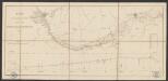
Plan du chemin de fer compris entre Liège et Aix-la-Chapelle
1 : 100000 Etablissement géographique
De klassis van Maastricht en landen van Overmaas
1 : 180000 door W.A. Bachiene ... J. van Jagen sculp. 1768. te Amsterdam : by D. onder de Linden
LIMBURGI Ducatus et Comitatus Nova Descriptio
1 : 110000 Limburg (Belgie : provincie) Visscher, Nicolaus per N. Visscher
Dvcatvs Limbvrgvm
1 : 180000 Mollova mapová sbírka Martini, Aegidius Schenk, Peter I
Dvcatvs Limbvrgvm
1 : 266000 Mollova mapová sbírka Merian, Matthaeus Merian, Matthäus
Dvcatvs Limbvrgvm
1 : 180000 Mollova mapová sbírka Martini, Aegidius Blaeu, Joan I.
Dvcatvs Limbvrgvm
1 : 175000 Mollova mapová sbírka Martini, Aegidius