Maps of Clavier

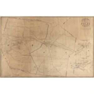
Plan parcellaire de la commune de Pailhe : avec les mutations
1 : 5000 Royal Library of Belgium Map Room Popp, Philippe Christian (1805-1879) Popp, Philippe Christian (1805-1879)
Plan parcellaire de la commune de Vyle et Tharoul : avec les mutations
1 : 5000 Royal Library of Belgium Map Room Popp, Philippe Christian (1805-1879) Popp, Philippe Christian (1805-1879)
Plan parcellaire de la commune de Modave : avec les mutations
1 : 5000 Royal Library of Belgium Map Room Popp, Philippe Christian (1805-1879) Popp, Philippe Christian (1805-1879)
Plan parcellaire de la commune de Bois-et-Borsu : avec les mutations
1 : 5000 Royal Library of Belgium Map Room Popp, Philippe Christian (1805-1879) Popp, Philippe Christian (1805-1879)
Plan parcellaire de la commune de Vierset : avec les mutations
1 : 5000 Royal Library of Belgium Map Room Popp, Philippe Christian (1805-1879) Popp, Philippe Christian (1805-1879)
Huy mit der gegend auff 2 Stunden.
1 : 150000 Mollova mapová sbírka Bodenehr, Gabriel Bodenehr, Gabriel
Comté de Namur
1 : 116600 Mollova mapová sbírka Fricx, Eugène Henry Covens, Johannes I
[Carte particuliere des environs de Namur, Huy, Dinant, Philippeville, etc.]
Belgie Fricx, Eugene Henry chez Eugene Henry Fricx
Comitatus Namurci tabula
1 : 130000 Wit, Frederick de Frederico de Wit
COMITATUS NAMURCI Emendata Delineatio
1 : 120000 Belgie Visscher, Nicolaus per Nicolaum Visscher
Comté de Namur
1 : 115000 A Amsterdam : chez Cóvens et Mortier
XIV ; 3.L., uit: Carte chorographique des Pays-Bas Autrichiens / ... par le Comte de Ferraris ; gravée par L.A. Dupuis
1 : 86400 Annotatie: Bladen linksboven genummerd met Romeinse cijfers, rechtsboven met een cijfer en een letter; Met opdracht aan keizer Joseph II (bl.XVI); Met plattegrond van Brussel (bl. XXI), overzichtskaart (bl. XXII) en bladwijzer (bl. XXIII); Annotatie geografische gegevens: Schaalstokken: Echelle de Toises ou de Lieues communes de France; Echelle de Verges ou de Lieues de Brabant; Echelle de Milles d'Allemagne (bl. XVII); Echelle de Mètres; In de hoeken lengte- en breedtematen T.M.e en T.P.e Joseph-Jean François Ferraris Comte de 1726-1814; L.A. Dupuis [S.l. : s.n.]
NAMVRCVM | COMITATVS
Auctore Iohann. Surhonio. [Amsterdam : Joan Blaeu]
Namurcum Comitatus. [Karte], in: Theatrum orbis terrarum, S. 111.
1 Karte aus Atlas Ortelius, Abraham

[Kaart], uit: Carte routière des environs de Namur
1 : 160000 Bruxelles : De Boeck
Namurcum Comitatus 1632 [Karte], in: Gerardi Mercatoris et I. Hondii Newer Atlas, oder, Grosses Weltbuch, Bd. 1, S. 434.
1 Karte aus Atlas Mercator, Gerhard und Hondius, Jodocus Jansson, Jan
NAMVRCVM | COMITATVS
Auctore Iohann. Surhonio. [Amsterdam : Joan Blaeu]
Namurcum Comitatus. [Karte], in: Theatrum orbis terrarum, S. 177.
1 Karte aus Atlas Ortelius, Abraham Vrients, Jan Baptista
Namvrcvm Comitatvs
1 : 140000 Mollova mapová sbírka Surhon, Jean de Schenk, Peter I


Leodiensis Episcopatus
1 : 130000 Mollova mapová sbírka Visscher, Nicolaes Schenk, Peter I
Carte particulière des mouvements faits, et des postes occupez par les armées des aliez commandées par le Roy de la Grande Bretagne et celles de France commandées par le Marechal de Villeroy pendant le siège de namur, 1695
1 : 160000 A Amsteldam : chez N. Visscher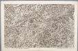
XIV, uit: Carte chorographique des Pays-Bas Autrichiens / ... par le Comte de Ferraris ; gravée par L.A. Dupuis
1 : 86400 Annotatie: Lit.: Les militaires et la cartographie des Pays-Bas méridionaux et de la Principauté de Liège à la fin du XVIIe et au XVIII siècle / Claire Lemoine-Isabeau. - Bruxelles, 1984, p. 206-212; La cartographie au XVIIIe siècle et l'oeuvre du Comte de Ferraris (1726-1814) : colloque international, Spa, 8-11 sept. 1976. - Bruxelles, 1978; Met opdracht aan keizer Joseph II (bl.XVI); Met plattegrond van Brussel (bl. XXI), overzichtskaart (bl. XXII) en bladwijzer (bl. XXIII); Ontbreekt: bl. I-III en XXI; Voor aanwezige bladen zie overzichtsblad Ferraris, Johann Joseph; Dupuis, L. A. [S.l. : s.n.]
Namurcum Comitatus [Karte], in: Theatrum orbis terrarum, sive, Atlas novus, Bd. 1, S. 397.
1 Karte aus Atlas Blaeu, Joan Blaeu, Willem Janszoon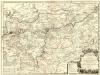
Le Comté de Namur
1 : 140000 Mollova mapová sbírka Nolin, Jean-Baptiste Nolin, Jean Baptiste II.
Comitatus Namurci emendata delineatio
1 : 130000 nuperrime in lucem edita per Nicolaum Visscher [Amsterdam] : [Nicolaas Visscher]
Namurcum Comitatus [Karte], in: Novus atlas absolutissimus, Bd. 3, S. 153.
1 Karte aus Atlas Janssonius Offizin