Maps of Sint-Joris

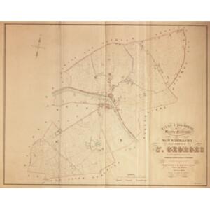
Plan parcellaire de la commune de St Georges : avec les mutations jusqu'en 1843
1 : 5000 Royal Library of Belgium Map Room Popp, Philippe Christian (1805-1879) Popp, Philippe Christian (1805-1879)
Plan parcellaire de la commune de Beernem : avec les mutations
1 : 5000 Royal Library of Belgium Map Room Popp, Philippe Christian (1805-1879) Popp, Philippe Christian (1805-1879)
Plan parcellaire de la commune de Knesselaere : avec les mutations
1 : 5000 Royal Library of Belgium Map Room Popp, Philippe Christian (1805-1879) Popp, Philippe Christian (1805-1879)
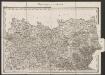
13 Bruges, uit: [Belgique 1:40.000]
1 : 40000 Annotatie: Voor aanwezige bladen zie overzichtsblad Bruxelles : Dépot de la Guerre
Carte Particuliere des Environs de Bruges, Ostende, Damme, l'Ecluse et Autres
1 : 250000 Mollova mapová sbírka Seutter, Matthäus Lotter, Tobias Conrad Seutter, Matthäus
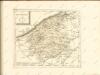
Flandriae Comitatus Pars Septentrionalis
1 : 133000 Mollova mapová sbírka Visscher, Nicolaes Schenk, Peter II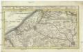
Brugge, Gent, Damme, Oostende, Schluys, und andere nah anliegende Staette Plaetze und Vestungen mitt deren Gegenden
1 : 115000 Belgie Bodenehr, Gabriel G. Bodenehr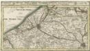
Brugge, Gent, Damme, Oostende, Schluys und andere Nah an liegende Staette Plaetze und Vestungen mitt deren Gegenden
1 : 250000 Mollova mapová sbírka Bodenehr, Gabriel Bodenehr, Gabriel
VII, uit: Carte chorographique des Pays-Bas Autrichiens / ... par le Comte de Ferraris ; gravée par L.A. Dupuis
1 : 86400 Annotatie: Lit.: Les militaires et la cartographie des Pays-Bas méridionaux et de la Principauté de Liège à la fin du XVIIe et au XVIII siècle / Claire Lemoine-Isabeau. - Bruxelles, 1984, p. 206-212; La cartographie au XVIIIe siècle et l'oeuvre du Comte de Ferraris (1726-1814) : colloque international, Spa, 8-11 sept. 1976. - Bruxelles, 1978; Met opdracht aan keizer Joseph II (bl.XVI); Met plattegrond van Brussel (bl. XXI), overzichtskaart (bl. XXII) en bladwijzer (bl. XXIII); Ontbreekt: bl. I-III en XXI; Voor aanwezige bladen zie overzichtsblad Ferraris, Johann Joseph; Dupuis, L. A. [S.l. : s.n.]
VII ; 2.J., uit: Carte chorographique des Pays-Bas Autrichiens / ... par le Comte de Ferraris ; gravée par L.A. Dupuis
1 : 86400 Annotatie: Bladen linksboven genummerd met Romeinse cijfers, rechtsboven met een cijfer en een letter; Met opdracht aan keizer Joseph II (bl.XVI); Met plattegrond van Brussel (bl. XXI), overzichtskaart (bl. XXII) en bladwijzer (bl. XXIII); Annotatie geografische gegevens: Schaalstokken: Echelle de Toises ou de Lieues communes de France; Echelle de Verges ou de Lieues de Brabant; Echelle de Milles d'Allemagne (bl. XVII); Echelle de Mètres; In de hoeken lengte- en breedtematen T.M.e en T.P.e Joseph-Jean François Ferraris Comte de 1726-1814; L.A. Dupuis [S.l. : s.n.]
Flandriae partes duae, quarum altera proprietaria, altera imperialis vulgo dicitur
1 : 150000 Flandry Blaeu, Joan Guilj. et Joh. Blaeu
Franconatvs vulgo het Vrye
1 : 190000 Nizozemsko Blaeu, Joan Guiljelmus et Iohannes Blaeuw
Map of water supply: Ghent
1 : 100000 Series of maps on water supplies. Ghent. War Office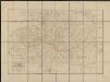
Carte topographique des rives de l'Escaut Occidental et du Canal de Gand à Terneuzen, indiquant les poldres, digues, écluses, waterinques ainsi que les limites des Flandres et de la Zélande
1 : 90000 par A.E.G. [= Albert Eugène Gheldolf] P.J. Doms fecit. Bruxelles : Ph. Vandermaelen
Flandriae Comitatus Pars Batava
1 : 133000 Mollova mapová sbírka Visscher, Nicolaes Schenk, Peter II
Flandriae comitatus pars Batava tam in ejusdem subjacentia quam vicina territoria
1 : 150000 accuratissima divisa per Nicolaum Visscher Amst. Bat. [Amsterdam] : nunc apud Petrum Schenk Iunior
Flandriae tevtonicae pars orientalior
1 : 190000 Flandry Blaeu, Joan Guiljelmus et Iohannes Blaeuw exc.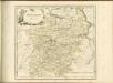

FLANDRIÆ | TEVTONICÆ | PARS ORIENTALIOR
Guilielmus et Iohannes Blaeuw exc. Amsterdami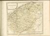

EPISCOPATVS | BRVGENSIS
[Amsterdam : Joan Blaeu]
FRANCONATVS, | Vulgo | HET VRYE
Guilielmus et Iohannes Blaeuw exc. Amsterdami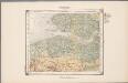
21. Walcheren, uit: Geologische kaart van Nederland / door W.C.H. Staring ; bew. aan de Topographische Inrichting
1 : 200000 Winand Carel Hugo Staring 1808-1877; Topographische Inrichting, 's-Gravenhage 's-Gravenhage : Belinfante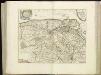
[107][110] Pars Flandriae orientalis ..., uit: Atlas sive Descriptio terrarum orbis
Annotatie: Gedigitaliseerde versie. Amsterdam. Heiloo : Picturae (vervaardiger), 2015. tiff-bestand. Gedigitaliseerd: 07-01-2015; Origineel: Universiteitsbibliotheek Vrije Universiteit (XL.05127.-) ; Netherlands; Titelpagina ontbreekt Wit, Frederik de Amsterdam : Frederick de Wit
Flandriae Teutonicae Pars Orientalior [Karte], in: Theatrum orbis terrarum, sive, Atlas novus, Bd. 1, S. 370.
1 Karte aus Atlas Blaeu, Joan Blaeu, Willem Janszoon
Reliefkarte von Flandern
Flandry Franckh'sche Verlagshandlung
Flandriae Teutonicae Pars Orientalior [Karte], in: Le théâtre du monde, ou, Nouvel atlas contenant les chartes et descriptions de tous les païs de la terre, Bd. 1, S. 394.
1 Karte aus Atlas Blaeu, Willem Janszoon und Blaeu, Joan Blaeu, Willem Janszoon
Flandriae Teutonicae Pars Orientalior [Karte], in: Novus Atlas, das ist, Weltbeschreibung, Bd. 1, S. 357.
1 Karte aus Atlas Blaeu, Joan Blaeu, Willem Janszoon