Maps of Avelgem

Plan parcellaire de la commune de Moen : avec les mutations
1 : 5000 Royal Library of Belgium Map Room Popp, Philippe Christian (1805-1879) Popp, Philippe Christian (1805-1879)
Plan parcellaire de la commune de Heestert : avec les mutations
1 : 5000 Royal Library of Belgium Map Room Popp, Philippe Christian (1805-1879) Popp, Philippe Christian (1805-1879)
Plan parcellaire de la commune de St Genois : avec les mutations
1 : 5000 Royal Library of Belgium Map Room Popp, Philippe Christian (1805-1879) Popp, Philippe Christian (1805-1879)
Plan parcellaire de la commune de Autryve : avec les mutations
1 : 5000 Royal Library of Belgium Map Room Popp, Philippe Christian (1805-1879) Popp, Philippe Christian (1805-1879)
Plan parcellaire de la commune de Bossut : avec les mutations
1 : 2500 Royal Library of Belgium Map Room Popp, Philippe Christian (1805-1879) Popp, Philippe Christian (1805-1879)
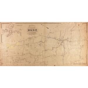
Plan parcellaire de la commune de Avelghem : avec les mutations
1 : 2500 Royal Library of Belgium Map Room Popp, Philippe Christian (1805-1879) Popp, Philippe Christian (1805-1879)
Disegno di Covtray
Kortrijk (Belgie) Bouttats, Gerhaert
Plan parcellaire de la commune de Ooteghem : avec les mutations
1 : 5000 Royal Library of Belgium Map Room Popp, Philippe Christian (1805-1879) Popp, Philippe Christian (1805-1879)
Plan parcellaire de la commune de Sweveghem : avec les mutations
1 : 5000 Royal Library of Belgium Map Room Popp, Philippe Christian (1805-1879) Popp, Philippe Christian (1805-1879)
Plan parcellaire de la commune de Escanaffles : avec les mutations
1 : 5000 Royal Library of Belgium Map Room Popp, Philippe Christian (1805-1879) Popp, Philippe Christian (1805-1879)
Plan parcellaire de la commune de Helchin : avec les mutations
1 : 5000 Royal Library of Belgium Map Room Popp, Philippe Christian (1805-1879) Popp, Philippe Christian (1805-1879)
Plan parcellaire de la commune de Coyghem : avec les mutations
1 : 5000 Royal Library of Belgium Map Room Popp, Philippe Christian (1805-1879) Popp, Philippe Christian (1805-1879)
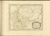
CASTELLANIA | ALDENARDENSIS
[Amsterdam : Joan Blaeu]
Carte particuliere des environs de Menin, Courtray, Ypre, Dixmunde, et Deynse
1 : 110000 Belgie Fricx, Eugene Henry chez Eugene Henry Friex
Carte Particuliere des environs de Menin, Courtray, Ypre, Dixmude et Deynse
1 : 116600 Mollova mapová sbírka Fricx, Eugène Henry Harrewyn, Jacques Fricx, Eugené Henry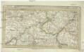
Menin in Flandern mitt nahegelegenen Staedten Ypern, Cortryck, Ryssel, Dornick etc
1 : 252000 Flandry Bodenehr, Gabriel G. Bodenehr
CASTELLANIÆ | CORTVRIACENSIS | TABVLA
[Amsterdam : Joan Blaeu]
Carte Particuliere des environs de Menin, Courtray, Ypre, Dixmude et Deynse
1 : 250000 Mollova mapová sbírka Seutter, Matthäus Seutter, Matthäus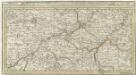
Menin in Flandern mitt nahe gelegenen Staedtten Ypern, Cortryck, Ryssel, Dornick etc.
1 : 250000 Mollova mapová sbírka Bodenehr, Gabriel Bodenehr, Gabriel
Le Diocese de Tournay
1 : 150000 Mollova mapová sbírka Cappelier, Bernard Jaillot, Alexis Hubert
Flandriae Comitatus Pars Media
1 : 133000 Mollova mapová sbírka Visscher, Nicolaes Schenk, Peter II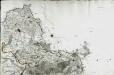
[Lille]
1 Blatt : 60 x 91 cm s.n.
Plan de la situation de l'Armée allié campée au bord de l'Eescaut 1744, de même que l'Armée françoise, retranchée derrière La Lis, l'année 1744
1 : 140000
Galloflandria
1 : 170000 Douai (Francie) Doué, Martin Blaeu, Willem Janszoon Guiljelmus Blaeu
GALLOFLANDRIA, | in qua CASTELLANIÆ | LILANA, DVACENA, & ORCHIESIA, cum dependentibus; | necnon TORNACVM, & TORNACESIVM
Auctore Martino Doué Gallo-Flandro. Guiljelmus Blaeu excudit.
Flandriae comitatus pars media, comprehendens castellaniam Yprensem, Cortracensem, Aldenardensem
1 : 130000 per Nicol. Visscher Amst. Bat. Amst. Bat. : per Nicol. Visscher
Flandriae Comitatus Pars Australis
1 : 133000 Mollova mapová sbírka Visscher, Nicolaes Schenk, Peter II
Le Diocese De Tournay ou font Exactement Marquées Les Lignes Levé & Gravé Par Ordre Expres Du Roy [...] [Karte], in: Atlas nouveau, contenant toutes les parties du monde [...], Bd. 2, S. 52.
1 Karte aus Atlas Sanson, Nicolas Jaillot, Alexis Hubert und Mortier, Pieter
Gallo Flandria, in qua Castellaniae Lilana, Duacena, & Archiesia, cum dependentibus; neenon Tornacum,& Tornacesium. [Karte], in: Novus Atlas, das ist, Weltbeschreibung, Bd. 1, S. 368.
1 Karte aus Atlas Blaeu, Joan Blaeu, Willem Janszoon