Maps of Loker

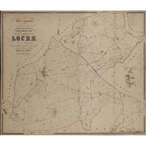
Plan parcellaire de la commune de Locre : avec les mutations
1 : 5000 Royal Library of Belgium Map Room Popp, Philippe Christian (1805-1879) Popp, Philippe Christian (1805-1879)
France & Belgium Scale 1 : 25,000, Tourcoing
Sheet 52NW from the map series: France & Belgium. Scale 1 : 25,000. [G.S.G.S. No. 4041. A.M.S. M863] [London] : War Office
Plan parcellaire de la commune de Reninghelst : avec les mutations
1 : 5000 Royal Library of Belgium Map Room Popp, Philippe Christian (1805-1879) Popp, Philippe Christian (1805-1879)
Plan parcellaire de la commune de Reninghelst : avec les mutations
1 : 5000 Royal Library of Belgium Map Room Popp, Philippe Christian (1805-1879) Popp, Philippe Christian (1805-1879)
Plan parcellaire de la commune de Dranoutre : avec les mutation
1 : 5000 Royal Library of Belgium Map Room Popp, Philippe Christian (1805-1879) Popp, Philippe Christian (1805-1879)
Plan parcellaire de la commune de Westoutre : avec les mutations
1 : 5000 Royal Library of Belgium Map Room Popp, Philippe Christian (1805-1879) Popp, Philippe Christian (1805-1879)
Plan parcellaire de la commune de Kemmel : avec les mutations
1 : 5000 Royal Library of Belgium Map Room Popp, Philippe Christian (1805-1879) Popp, Philippe Christian (1805-1879)
Ypres. Sheeet 28. no.3
1 : 40000 First World War map of Ypres. Sheeet 28. 1915. [GSGS 2743] Has height shading and contours. War Office
Ypres. Sheeet 28. no.2
1 : 40000 First World War map of Ypres. Sheeet 28. 1915. [GSGS 2743] Has height shading and contours. War Office
Ypres. Sheeet 28. no.1
1 : 40000 First World War map of Ypres. Sheeet 28. 1915. [GSGS 2743] Has height shading and contours. War Office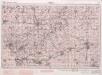
Ypres. Sheeet 28. no.4
1 : 40000 First World War map of Ypres. Sheeet 28. 1915. [GSGS 2743] Has height shading and contours. War Office
Carte chorographique des Pays - Bas Autrichiens...

XI ; 3.H., [Annonce de l'ouvrage], uit: Carte chorographique des Pays-Bas Autrichiens / ... par le Comte de Ferraris ; gravée par L.A. Dupuis
1 : 86400 Annotatie: Bladen linksboven genummerd met Romeinse cijfers, rechtsboven met een cijfer en een letter; Met opdracht aan keizer Joseph II (bl.XVI); Met plattegrond van Brussel (bl. XXI), overzichtskaart (bl. XXII) en bladwijzer (bl. XXIII); Annotatie geografische gegevens: Schaalstokken: Echelle de Toises ou de Lieues communes de France; Echelle de Verges ou de Lieues de Brabant; Echelle de Milles d'Allemagne (bl. XVII); Echelle de Mètres; In de hoeken lengte- en breedtematen T.M.e en T.P.e Joseph-Jean François Ferraris Comte de 1726-1814; L.A. Dupuis [S.l. : s.n.]
CASTELLANIA | FURNENSIS
[Amsterdam : Joan Blaeu]
Map of water supply: Ostend
1 : 100000 Series of maps on water supplies. Ostend. War Office
Carte particuliere des environs de Menin, Courtray, Ypre, Dixmunde, et Deynse
1 : 110000 Belgie Fricx, Eugene Henry chez Eugene Henry Friex
XI [Annonce de l'ouvrage], uit: Carte chorographique des Pays-Bas Autrichiens / ... par le Comte de Ferraris ; gravée par L.A. Dupuis
1 : 86400 Annotatie: Lit.: Les militaires et la cartographie des Pays-Bas méridionaux et de la Principauté de Liège à la fin du XVIIe et au XVIII siècle / Claire Lemoine-Isabeau. - Bruxelles, 1984, p. 206-212; La cartographie au XVIIIe siècle et l'oeuvre du Comte de Ferraris (1726-1814) : colloque international, Spa, 8-11 sept. 1976. - Bruxelles, 1978; Met opdracht aan keizer Joseph II (bl.XVI); Met plattegrond van Brussel (bl. XXI), overzichtskaart (bl. XXII) en bladwijzer (bl. XXIII); Ontbreekt: bl. I-III en XXI; Voor aanwezige bladen zie overzichtsblad Ferraris, Johann Joseph; Dupuis, L. A. [S.l. : s.n.]
Carte Particuliere des environs de Menin, Courtray, Ypre, Dixmude et Deynse
1 : 116600 Mollova mapová sbírka Fricx, Eugène Henry Harrewyn, Jacques Fricx, Eugené Henry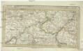
Menin in Flandern mitt nahegelegenen Staedten Ypern, Cortryck, Ryssel, Dornick etc
1 : 252000 Flandry Bodenehr, Gabriel G. Bodenehr
NOVA ET EXACTA TABVLA GEOGRAPHICA SALÆ ET CASTELLANIÆ IPRENSIS. De Casselrie van Ipre. LA CHASTELENIE D'IPRE. ANNO M DC XXXXI
Vedastus du Plouich fec. Henricus Hondius excudebat
VI, uit: Carte chorographique des Pays-Bas Autrichiens / ... par le Comte de Ferraris ; gravée par L.A. Dupuis
1 : 86400 Annotatie: Lit.: Les militaires et la cartographie des Pays-Bas méridionaux et de la Principauté de Liège à la fin du XVIIe et au XVIII siècle / Claire Lemoine-Isabeau. - Bruxelles, 1984, p. 206-212; La cartographie au XVIIIe siècle et l'oeuvre du Comte de Ferraris (1726-1814) : colloque international, Spa, 8-11 sept. 1976. - Bruxelles, 1978; Met opdracht aan keizer Joseph II (bl.XVI); Met plattegrond van Brussel (bl. XXI), overzichtskaart (bl. XXII) en bladwijzer (bl. XXIII); Ontbreekt: bl. I-III en XXI; Voor aanwezige bladen zie overzichtsblad Ferraris, Johann Joseph; Dupuis, L. A. [S.l. : s.n.]
Carte Particuliere des environs de Menin, Courtray, Ypre, Dixmude et Deynse
1 : 250000 Mollova mapová sbírka Seutter, Matthäus Seutter, Matthäus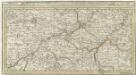
Menin in Flandern mitt nahe gelegenen Staedtten Ypern, Cortryck, Ryssel, Dornick etc.
1 : 250000 Mollova mapová sbírka Bodenehr, Gabriel Bodenehr, Gabriel
DITIO CASLETANA IN COMITATU FLANDRIÆ Vulgó Cassel Ambacht
Vedastus du Plouich invenit et fecit Amstelodami | Sumtibus Henrici Hondy
Galloflandria
1 : 170000 Douai (Francie) Doué, Martin Blaeu, Willem Janszoon Guiljelmus Blaeu
Flandriae Comitatus pars occidentalis
1 : 133000 Mollova mapová sbírka Visscher, Nicolaes Schenk, Peter II
Map showing progress in Ypres area. Oct. 1917.
1 : 40000 First World War map showing progress in Ypres area. 12th October 1917. War Office
Flandriae comitatus pars media, comprehendens castellaniam Yprensem, Cortracensem, Aldenardensem
1 : 130000 per Nicol. Visscher Amst. Bat. Amst. Bat. : per Nicol. Visscher
Map of water supply: Hazebrouck
1 : 100000 Series of maps on water supplies. 2nd Army area water supply. Secret. Hazebrouck War Office