Maps of Clairfayts

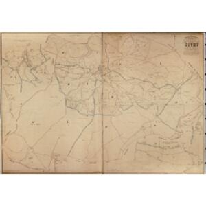
Plan parcellaire de la commune de Sivry : avec les mutations
1 : 5000 Royal Library of Belgium Map Room Popp, Philippe Christian (1805-1879) Popp, Philippe Christian (1805-1879)
Plan parcellaire de la commune de Monbliart : avec les mutations
1 : 5000 Royal Library of Belgium Map Room Popp, Philippe Christian (1805-1879) Popp, Philippe Christian (1805-1879)
Plan parcellaire de la commune de Grandrieu : avec les mutations
1 : 5000 Royal Library of Belgium Map Room Popp, Philippe Christian (1805-1879) Popp, Philippe Christian (1805-1879)
Plan parcellaire de la commune de Solre-Saint-Gery : avec les mutations
1 : 5000 Royal Library of Belgium Map Room Popp, Philippe Christian (1805-1879) Popp, Philippe Christian (1805-1879)
Plan parcellaire de la commune de Rance : avec les mutations
1 : 5000 Royal Library of Belgium Map Room Popp, Philippe Christian (1805-1879) Popp, Philippe Christian (1805-1879)
Plan parcellaire de la commune de Renlies : avec les mutations
1 : 5000 Royal Library of Belgium Map Room Popp, Philippe Christian (1805-1879) Popp, Philippe Christian (1805-1879)
Carte Particuliere des environs d'Avesnes, Landrecy, la Capelle, Guise
1 : 250000 Mollova mapová sbírka Seutter, Matthäus Seutter, Matthäus
Carte particuliere des environs d'Avesnes, Landrecy, La Capelle, Guise, etc
1 : 116600 Mollova mapová sbírka Fricx, Eugène Henry Fricx, Eugené Henry
Carte particuliere des environs d'Avesnes Landrecy, La Capelle, Guise
1 : 115000 A Amsterdam : chez Cóvens et Mortier
77 Rocroi.
1 : 86400 Cassini family; Cassini, Cesar-Francois, 1714-1784
Map of water supply: Namur
1 : 100000 Series of maps on water supplies. Namur. War Office
[Rocroy]
1 Blatt : 59 x 91 cm Brunet; Le Roy s.n.
XVIII, uit: Carte chorographique des Pays-Bas Autrichiens / ... par le Comte de Ferraris ; gravée par L.A. Dupuis
1 : 86400 Annotatie: Lit.: Les militaires et la cartographie des Pays-Bas méridionaux et de la Principauté de Liège à la fin du XVIIe et au XVIII siècle / Claire Lemoine-Isabeau. - Bruxelles, 1984, p. 206-212; La cartographie au XVIIIe siècle et l'oeuvre du Comte de Ferraris (1726-1814) : colloque international, Spa, 8-11 sept. 1976. - Bruxelles, 1978; Met opdracht aan keizer Joseph II (bl.XVI); Met plattegrond van Brussel (bl. XXI), overzichtskaart (bl. XXII) en bladwijzer (bl. XXIII); Ontbreekt: bl. I-III en XXI; Voor aanwezige bladen zie overzichtsblad Ferraris, Johann Joseph; Dupuis, L. A. [S.l. : s.n.]
Tractatus inter Sabim et Mosam
1 : 130000 Mollova mapová sbírka Visscher, Nicolaes Visscher, Nicolaus
Comitatus Namur Censis cum locis Ejusdem munitioribus ac regionibus finitimis ex observationibus recentissimis accuratissime designatus calamo et sumtibus
1 : 150000 Mollova mapová sbírka Seutter, Matthäus Seutter, Matthäus
Comté De Namur [Karte], in: Atlas nouveau, contenant toutes les parties du monde [...], Bd. 2, S. 69.
1 Karte aus Atlas Sanson, Nicolas Jaillot, Alexis Hubert und Mortier, Pieter
Le Comte de Haynaut Divisé en plusieurs Pays etc.
1 : 208000 Mollova mapová sbírka Nolin, Jean-Baptiste Nolin, Jean Baptiste II.
Comitatus Hannoniae
1 : 216000 Mollova mapová sbírka Homann, Johann Baptist Homann, Johann Baptista
Nova et Accurata Hannoniae Comitatus
1 : 190000 Mollova mapová sbírka Danckerts, Theodorus Danckerts, Theodor
[21], uit: Hydro-Oro und Chorographische General Karte des Koenigreichs der Niederlande und der angrenzenden Länder bis Paris : mit der Angabe der Kunst und Heer-Strassen und der Entfernung der Poststationen / ... zusammengetragen und reducirt von ... Wilhelm Müller
1 : 400000 titelvariant: Generalkarte des Koenigreichs Hannover; Annotatie: 1e supplement bij: Generalkarte des Koenigreichs Hannover (1818) Müller, Wilhelm (fl. 1818) [Hannover : Wilhelm Müller]
Nobilis Hannoniae comitatvs descrip
1 : 370000 Henegavsko (Belgie : provincie) Surhon, Jacques de
Le Comté de Haynaut, Diviséen Chatellenies, Balliages, Prevostés, &c.
Mollova mapová sbírka Jaillot, Alexis-Hubert Jaillot, Alexis Hubert
Valenciennes 96, uit: [W. Liebenow's Special-Karte von Mittel-Europa]
1 : 300000 titelvariant: W. Liebenow's Mittel-Europa; Annotatie: Titel boven de bladen: W. Liebenow's Mittel-Europa Johannes Wilhelm Liebenow 1822-1897 Hannover : Hermann Oppermann
Hannonia Comitatus
1 : 216000 Mollova mapová sbírka Valk, Gerhard Valck, Gerard
Comitatûs Hannoniæ in suas quasque castellanias balliviatvs præfecturas et territoria accuratè divisi descriptio
1 Karte : Kupferdruck ; 47 x 56 cm Homann Johann Baptist Homann
Comitatus Hannoniae Tabula
1 : 208000 Mollova mapová sbírka Penez, Alexander Schenk, Peter II
Comitaus Hanoniae in suas quasque castellanias, balliviatvs praefecturas et territoria accurate divisi descriptio
1 : 220000 Belgie Homann, Johann Baptist Joh. Bapt. Homanno
Valenciennes 96, uit: Special-Karte von Mittel-Europa / nach amtlichen Quellen bearbeitet von W. Liebenow
1 : 300000 titelvariant: W. Liebenow's Mittel-Europa; Annotatie: Titel boven de bladen: W. Liebenow's Mittel-Europa Johannes Wilhelm Liebenow 1822-1897 Frankfurt a. M. : Ludwig Ravenstein
Correctissima Descriptio Hannoniae Comitatus
1 : 216000 Mollova mapová sbírka Wit, Frederik de Covens, Johannes I