Maps of Charleroi

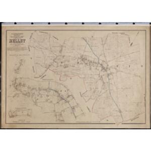
Plan parcellaire de la commune de Mellet : avec les mutations
1 : 5000 Royal Library of Belgium Map Room Popp, Philippe Christian (1805-1879) Popp, Philippe Christian (1805-1879)
Plan parcellaire de la commune de Wayaux : avec les mutations
1 : 5000 Royal Library of Belgium Map Room Popp, Philippe Christian (1805-1879) Popp, Philippe Christian (1805-1879)
Plan parcellaire de la commune de Villers-Perwin : avec les mutations
1 : 5000 Royal Library of Belgium Map Room Popp, Philippe Christian (1805-1879) Popp, Philippe Christian (1805-1879)
Plan parcellaire de la commune de Saint-Amand Lez-Fleurus : avec les mutations
1 : 5000 Royal Library of Belgium Map Room Popp, Philippe Christian (1805-1879) Popp, Philippe Christian (1805-1879)
Plan parcellaire de la commune de Heppignies : avec les mutations
1 : 5000 Royal Library of Belgium Map Room Popp, Philippe Christian (1805-1879) Popp, Philippe Christian (1805-1879)
Plan parcellaire de la commune de Fleurus : avec les mutations
1 : 5000 Royal Library of Belgium Map Room Popp, Philippe Christian (1805-1879) Popp, Philippe Christian (1805-1879)
Plan parcellaire de la commune de Thiméon : avec les mutations
1 : 5000 Royal Library of Belgium Map Room Popp, Philippe Christian (1805-1879) Popp, Philippe Christian (1805-1879)
Plan parcellaire de la commune de Liberchies : avec les mutations
1 : 5000 Royal Library of Belgium Map Room Popp, Philippe Christian (1805-1879) Popp, Philippe Christian (1805-1879)
Plan parcellaire de la commune de Gosselies : avec les mutations
1 : 5000 Royal Library of Belgium Map Room Popp, Philippe Christian (1805-1879) Popp, Philippe Christian (1805-1879)
Plan parcellaire de la commune de Frasnes lez-Gosselies : avec les mutations
1 : 5000 Royal Library of Belgium Map Room Popp, Philippe Christian (1805-1879) Popp, Philippe Christian (1805-1879)
Plan parcellaire de la commune de Wangenies : avec les mutations
1 : 5000 Royal Library of Belgium Map Room Popp, Philippe Christian (1805-1879) Popp, Philippe Christian (1805-1879)
Plan parcellaire de la commune de Wagnelée : avec les mutations
1 : 5000 Royal Library of Belgium Map Room Popp, Philippe Christian (1805-1879) Popp, Philippe Christian (1805-1879)
Comitatus Namurci Tabula
Mollova mapová sbírka Wit, Frederik de Covens, Johannes I
Comitatvs Namvr
1 : 100000 Fricx, Eugene Henry par Homaniannos Heredes
The Battle of Waterloo
Tyler Ackermann
Die Grafschafft Namur Nach dero Eigendlichen Lager
1 : 567000 Mollova mapová sbírka Bodenehr, Gabriel Bodenehr, Gabriel
COMITATUS NAMURCI Emendata Delineatio
1 : 120000 Belgie Visscher, Nicolaus per Nicolaum Visscher
Comitatus Namurci Emendata Delineatio
1 : 300000 Mollova mapová sbírka Visscher, Nicolaes Schenk, Peter II
Carte du Comté de Namvr
1 : 130000 Mollova mapová sbírka Fricx, Eugène Henry Homann, Johann Baptista - dědici
XIII ; 3.K., uit: Carte chorographique des Pays-Bas Autrichiens / ... par le Comte de Ferraris ; gravée par L.A. Dupuis
1 : 86400 Annotatie: Bladen linksboven genummerd met Romeinse cijfers, rechtsboven met een cijfer en een letter; Met opdracht aan keizer Joseph II (bl.XVI); Met plattegrond van Brussel (bl. XXI), overzichtskaart (bl. XXII) en bladwijzer (bl. XXIII); Annotatie geografische gegevens: Schaalstokken: Echelle de Toises ou de Lieues communes de France; Echelle de Verges ou de Lieues de Brabant; Echelle de Milles d'Allemagne (bl. XVII); Echelle de Mètres; In de hoeken lengte- en breedtematen T.M.e en T.P.e Joseph-Jean François Ferraris Comte de 1726-1814; L.A. Dupuis [S.l. : s.n.]
XIII, uit: Carte chorographique des Pays-Bas Autrichiens / ... par le Comte de Ferraris ; gravée par L.A. Dupuis
1 : 86400 Annotatie: Lit.: Les militaires et la cartographie des Pays-Bas méridionaux et de la Principauté de Liège à la fin du XVIIe et au XVIII siècle / Claire Lemoine-Isabeau. - Bruxelles, 1984, p. 206-212; La cartographie au XVIIIe siècle et l'oeuvre du Comte de Ferraris (1726-1814) : colloque international, Spa, 8-11 sept. 1976. - Bruxelles, 1978; Met opdracht aan keizer Joseph II (bl.XVI); Met plattegrond van Brussel (bl. XXI), overzichtskaart (bl. XXII) en bladwijzer (bl. XXIII); Ontbreekt: bl. I-III en XXI; Voor aanwezige bladen zie overzichtsblad Ferraris, Johann Joseph; Dupuis, L. A. [S.l. : s.n.]
SECVNDA PARS | BRABANTIÆ | cuius urbs primaria | BRVXELLÆ
Descr. Michaele Florentio a Langren | Mathematico Regio. Guiljelmus Blaeu excudit (scale cartouche)

NAMVRCVM | COMITATVS
Auctore Iohann. Surhonio. [Amsterdam : Joan Blaeu]
Namurcum Comitatus. [Karte], in: Theatrum orbis terrarum, S. 111.
1 Karte aus Atlas Ortelius, Abraham
Secunda Pars Brabantiae cuius urbs primaria Bruxellae [Karte], in: Theatrum orbis terrarum, sive, Atlas novus, Bd. 1, S. 340.
1 Karte aus Atlas Blaeu, Joan Blaeu, Willem Janszoon
Secunda Pars Brabantiae cuius urbs primaria Bruxellae [Karte], in: Novus Atlas, das ist, Weltbeschreibung, Bd. 1, S. 319.
1 Karte aus Atlas Blaeu, Joan Blaeu, Willem Janszoon
Namurcum Comitatus 1632 [Karte], in: Gerardi Mercatoris et I. Hondii Newer Atlas, oder, Grosses Weltbuch, Bd. 1, S. 434.
1 Karte aus Atlas Mercator, Gerhard und Hondius, Jodocus Jansson, Jan