Maps of Beaumont

Plan parcellaire de la commune de Boussu lez-Walcourt : avec les mutations
1 : 5000 Royal Library of Belgium Map Room Popp, Philippe Christian (1805-1879) Popp, Philippe Christian (1805-1879)
Plan parcellaire de la commune de Erpion : avec les mutations
1 : 5000 Royal Library of Belgium Map Room Popp, Philippe Christian (1805-1879) Popp, Philippe Christian (1805-1879)
Plan parcellaire de la commune de Barbençon : avec les mutations
1 : 5000 Royal Library of Belgium Map Room Popp, Philippe Christian (1805-1879) Popp, Philippe Christian (1805-1879)
Plan parcellaire de la commune de Vergnies : avec les mutations
1 : 5000 Royal Library of Belgium Map Room Popp, Philippe Christian (1805-1879) Popp, Philippe Christian (1805-1879)
Plan parcellaire de la commune de Froidchapelle : avec les mutations
1 : 5000 Royal Library of Belgium Map Room Popp, Philippe Christian (1805-1879) Popp, Philippe Christian (1805-1879)
Plan parcellaire de la commune de Fourbechies : avec les mutations
1 : 5000 Royal Library of Belgium Map Room Popp, Philippe Christian (1805-1879) Popp, Philippe Christian (1805-1879)
Plan parcellaire de la commune de Renlies : avec les mutations
1 : 5000 Royal Library of Belgium Map Room Popp, Philippe Christian (1805-1879) Popp, Philippe Christian (1805-1879)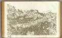
77 Rocroi.
1 : 86400 Cassini family; Cassini, Cesar-Francois, 1714-1784
Map of water supply: Namur
1 : 100000 Series of maps on water supplies. Namur. War Office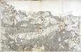
[Rocroy]
1 Blatt : 59 x 91 cm Brunet; Le Roy s.n.
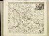
NAMVRCVM | COMITATVS
Auctore Iohann. Surhonio. [Amsterdam : Joan Blaeu]
Namurcum Comitatus. [Karte], in: Theatrum orbis terrarum, S. 111.
1 Karte aus Atlas Ortelius, Abraham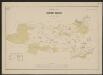
Namurcum Comitatus 1632 [Karte], in: Gerardi Mercatoris et I. Hondii Newer Atlas, oder, Grosses Weltbuch, Bd. 1, S. 434.
1 Karte aus Atlas Mercator, Gerhard und Hondius, Jodocus Jansson, Jan
NAMVRCVM | COMITATVS
Auctore Iohann. Surhonio. [Amsterdam : Joan Blaeu]
Namurcum Comitatus. [Karte], in: Theatrum orbis terrarum, S. 177.
1 Karte aus Atlas Ortelius, Abraham Vrients, Jan Baptista
XVIII, uit: Carte chorographique des Pays-Bas Autrichiens / ... par le Comte de Ferraris ; gravée par L.A. Dupuis
1 : 86400 Annotatie: Lit.: Les militaires et la cartographie des Pays-Bas méridionaux et de la Principauté de Liège à la fin du XVIIe et au XVIII siècle / Claire Lemoine-Isabeau. - Bruxelles, 1984, p. 206-212; La cartographie au XVIIIe siècle et l'oeuvre du Comte de Ferraris (1726-1814) : colloque international, Spa, 8-11 sept. 1976. - Bruxelles, 1978; Met opdracht aan keizer Joseph II (bl.XVI); Met plattegrond van Brussel (bl. XXI), overzichtskaart (bl. XXII) en bladwijzer (bl. XXIII); Ontbreekt: bl. I-III en XXI; Voor aanwezige bladen zie overzichtsblad Ferraris, Johann Joseph; Dupuis, L. A. [S.l. : s.n.]
Namvrcvm Comitatvs
1 : 140000 Mollova mapová sbírka Surhon, Jean de Schenk, Peter I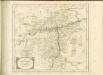


Tractatus inter Sabim et Mosam
1 : 130000 Mollova mapová sbírka Visscher, Nicolaes Visscher, Nicolaus
Comitatus Namurcensis
1 : 150000 Belgie Lotter, Tobias Conrad Tob. Conr. Lotter
Namurcum Comitatus [Karte], in: Theatrum orbis terrarum, sive, Atlas novus, Bd. 1, S. 397.
1 Karte aus Atlas Blaeu, Joan Blaeu, Willem Janszoon
Comitatus Namurci emendata delineatio
1 : 130000 nuperrime in lucem edita per Nicolaum Visscher [Amsterdam] : [Nicolaas Visscher]
Namurcum Comitatus [Karte], in: Novus atlas absolutissimus, Bd. 3, S. 153.
1 Karte aus Atlas Janssonius Offizin
Comitatus Namurci emendata delineatio
1 : 130000 nuperrime in lucem edita per Nicolaum Visscher [Amsterdam] : nunc apud Pet: Schenk Junior
Namurcum Comitatus. [Karte], in: Novus Atlas, das ist, Weltbeschreibung, Bd. 1, S. 345.
1 Karte aus Atlas Blaeu, Joan Blaeu, Willem Janszoon
Namurcum Comitatus [Karte], in: Le théâtre du monde, ou, Nouvel atlas contenant les chartes et descriptions de tous les païs de la terre, Bd. 1, S. 374.
1 Karte aus Atlas Blaeu, Willem Janszoon und Blaeu, Joan Blaeu, Willem Janszoon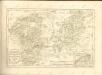

Carte de la Principauté de Liege et de la Comté de Namur
1 : 135000 Mollova mapová sbírka Maire, Christopher Kints, Everard