Maps of Zele

Plan parcellaire de la commune de Zele : avec les mutations
1 : 5000 Royal Library of Belgium Map Room Popp, Philippe Christian (1805-1879) Popp, Philippe Christian (1805-1879)
Plan parcellaire de la commune de Berlaere : avec les mutations
1 : 5000 Royal Library of Belgium Map Room Popp, Philippe Christian (1805-1879) Popp, Philippe Christian (1805-1879)
Plan parcellaire de la commune de Appels : avec les mutations
1 : 5000 Royal Library of Belgium Map Room Popp, Philippe Christian (1805-1879) Popp, Philippe Christian (1805-1879)
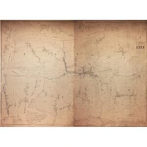
Commune de Zele : développements du village et du Hau Zandberg à l'échelle d'un à 1250, des Haux d'Ansevelde, Meerschkant, Avermaet, Veldeken et Durmen à l'échelle d'un à 2500
1 : 2500 Royal Library of Belgium Map Room Popp, Philippe Christian (1805-1879) Popp, Philippe Christian (1805-1879)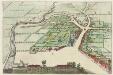
LOKEREN : [bird's-eye view]
[Amsterdam : Joan Blaeu]
Plan parcellaire de la ville de Lokeren : avec les mutations
1 : 1250 Royal Library of Belgium Map Room Popp, Philippe Christian (1805-1879) Popp, Philippe Christian (1805-1879)
Commune de Grembergen : développements du village des Haux Groot-Zand, Kleyn-Zand, Deynstraet et Lange-Straet
1 : 2500 Royal Library of Belgium Map Room Popp, Philippe Christian (1805-1879) Popp, Philippe Christian (1805-1879)
TENERAMONDA Vulgo DENDERMONDE : [plan and view from the south]
Bottom left inset: Dendermonde : [view from the north]. - 7.5 x 17 cm [Amsterdam : Joan Blaeu]
Développement de la ville de Termonde (intra muros)
1 : 1250 Royal Library of Belgium Map Room Popp, Philippe Christian (1805-1879) Popp, Philippe Christian (1805-1879)
Plan parcellaire de la ville de Lokeren : avec les mutations
1 : 5000 Royal Library of Belgium Map Room Popp, Philippe Christian (1805-1879) Popp, Philippe Christian (1805-1879)
Plan parcellaire de la ville de Termonde : avec les mutations
1 : 5000 Royal Library of Belgium Map Room Popp, Philippe Christian (1805-1879) Popp, Philippe Christian (1805-1879)
Plan parcellaire de la commune de Grembergen : avec les mutations
1 : 5000 Royal Library of Belgium Map Room Popp, Philippe Christian (1805-1879) Popp, Philippe Christian (1805-1879)
Plan parcellaire de la commune de Hamme Lez Termonde : avec les mutations
1 : 5000 Royal Library of Belgium Map Room Popp, Philippe Christian (1805-1879) Popp, Philippe Christian (1805-1879)
Plan parcellaire de la commune de Overmeire : avec les mutations
1 : 2500 Royal Library of Belgium Map Room Popp, Philippe Christian (1805-1879) Popp, Philippe Christian (1805-1879)
Plan parcellaire de la commune de Waesmunster : avec les mutations
1 : 5000 Royal Library of Belgium Map Room Popp, Philippe Christian (1805-1879) Popp, Philippe Christian (1805-1879)
Dendermonde, leggende in Spaans Vlaanderen aan de mont van de Dender zynde noyt ingenomen geweest, heeft den 5 sept.r 1706. na een belegering van 4 dagen voor 't gewelt der Geallieerde moeten bucken
Schenk, Pieter P. Schenk
Plan parcellaire de la commune de Uytbergen : avec les mutations
1 : 2500 Royal Library of Belgium Map Room Popp, Philippe Christian (1805-1879) Popp, Philippe Christian (1805-1879)
Plan parcellaire de la commune de Saint-Gilles lez-Termonde : avec les mutations
1 : 5000 Royal Library of Belgium Map Room Popp, Philippe Christian (1805-1879) Popp, Philippe Christian (1805-1879)
Développement du village de Waesmunster à l'échelle d'un à 1250
1 : 1250 Royal Library of Belgium Map Room Popp, Philippe Christian (1805-1879) Popp, Philippe Christian (1805-1879)
Plan parcellaire de la commune de Audegem : avec les mutations
1 : 5000 Royal Library of Belgium Map Room Popp, Philippe Christian (1805-1879) Popp, Philippe Christian (1805-1879)
Plan parcellaire de la commune de Wichelen : avec les mutations
1 : 5000 Royal Library of Belgium Map Room Popp, Philippe Christian (1805-1879) Popp, Philippe Christian (1805-1879)
Carte tres-particuliere du Pays de Waes
1 : 120000 Antverpy (Belgie) Fricx, Eugene Henry chez Eugene Henry Fricx
KAERTE | VAN | DE VIER AMBACHTEN
Gerard Coeck sculp. [Amsterdam : Joan Blaeu]
Flandriae partes duae, quarum altera proprietaria, altera imperialis vulgo dicitur
1 : 150000 Flandry Blaeu, Joan Guilj. et Joh. Blaeu
Marchionatus sacri imperii et dominii Mechelini tabula
1 : 115000 auctore F. de Wit. Gedruckt tot Amsterdam : by Frederick de Wit, in de Kalverstraet inde Witte Paskaert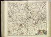
[120][123] Marchionatus Sacri Imperii et Dominii Mechelini tabula, uit: Atlas sive Descriptio terrarum orbis
Annotatie: Gedigitaliseerde versie. Amsterdam. Heiloo : Picturae (vervaardiger), 2015. tiff-bestand. Gedigitaliseerd: 07-01-2015; Origineel: Universiteitsbibliotheek Vrije Universiteit (XL.05127.-) ; Netherlands; Titelpagina ontbreekt Wit, Frederik de Amsterdam : Frederick de Wit
SECVNDA PARS | BRABANTIÆ | cuius urbs primaria | BRVXELLÆ
Descr. Michaele Florentio a Langren | Mathematico Regio. Guiljelmus Blaeu excudit (scale cartouche)