Maps of Kaprijke

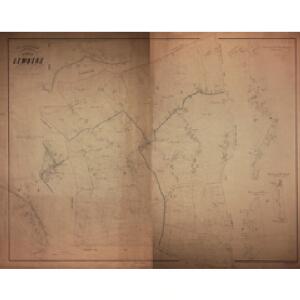
Plan parcellaire de la commune de Lembeke : avec les mutations
1 : 5000 Royal Library of Belgium Map Room Popp, Philippe Christian (1805-1879) Popp, Philippe Christian (1805-1879)
Plan parcellaire de la commune de Bassevelde : avec les mutations
1 : 5000 Royal Library of Belgium Map Room Popp, Philippe Christian (1805-1879) Popp, Philippe Christian (1805-1879)
Plan parcellaire de la commune de Eecloo : avec les mutations
1 : 5000 Royal Library of Belgium Map Room Popp, Philippe Christian (1805-1879) Popp, Philippe Christian (1805-1879)
Plan parcellaire de la commune de Caprycke : avec les mutations
1 : 5000 Royal Library of Belgium Map Room Popp, Philippe Christian (1805-1879) Popp, Philippe Christian (1805-1879)
Plan parcellaire de la commune de Waerschoot : avec les mutations
1 : 5000 Royal Library of Belgium Map Room Popp, Philippe Christian (1805-1879) Popp, Philippe Christian (1805-1879)
Plan parcellaire de la commune de Oost-Eecloo : avec les mutations
1 : 5000 Royal Library of Belgium Map Room Popp, Philippe Christian (1805-1879) Popp, Philippe Christian (1805-1879)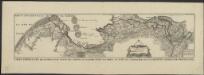
Carte particuliere des environs d'une partie des limites en Flandre, entre les terres de S.M.I. et Catholicque et celle des Etats Generaux des Provinces Unies
1 : 80000 levé par Nicolas Suly ... commencé le 15 frevvrier 1716 à Blanckenberg et fini le 30 maij à L'Ouverslacht E.L. Creite sc. A La Haye : chez H. Scheurleer
Nobilibus Amplissimisq. Dominis D. Georgio de la Faille Toparchae de Neulle etc. Praetori Totiq. collegio Supremae curiae feudalis regiae Veteris burgi Gandensis
1 : 110000 Mollova mapová sbírka Blaeu, Joan Blaeu, Cornelis
Bl. 29 Middelburg, 1917, uit: Atlas A.N.W.B.
1 : 200000 titelvariant: Atlas van Nederland van den A.N.W.B. Toeristenbond voor Nederland; Wielrijders-atlas van Nederland; Annotatie: Titel op bladwijzer: Atlas van Nederland van den A.N.W.B. Toeristenbond voor Nederland; Titel op legendablad: Wielrijders-atlas van Nederland; Voor aanwezige bladen zie overzichtsblad; Annotatie geografische gegevens: De serie bestaat uit 36 bladen ANWB ['s-Gravenhage : A.N.W.B.]
Bl. 29 Middelburg, 1905, uit: Atlas A.N.W.B.
1 : 200000 titelvariant: Atlas van Nederland van den A.N.W.B. Toeristenbond voor Nederland; Wielrijders-atlas van Nederland; Annotatie: Titel op bladwijzer: Atlas van Nederland van den A.N.W.B. Toeristenbond voor Nederland; Titel op legendablad: Wielrijders-atlas van Nederland; Voor aanwezige bladen zie overzichtsblad; Annotatie geografische gegevens: De serie bestaat uit 36 bladen ANWB ['s-Gravenhage : A.N.W.B.]
... Hanc Veteris Burgis novam tabulam...
[Amsterdam : Joan Blaeu]
Flandriae Comitatus Pars Septentrionalis
1 : 133000 Mollova mapová sbírka Visscher, Nicolaes Schenk, Peter II
Carte particuliere des environs d'Anvers, Gand, Hulst, et de tout le Pays de Waes
1 : 106000 Antverpy (Belgie) Fricx, Eugene Henry Harrewyn, Jacques chez Eugene Henry Friex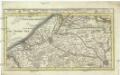
Brugge, Gent, Damme, Oostende, Schluys, und andere nah anliegende Staette Plaetze und Vestungen mitt deren Gegenden
1 : 115000 Belgie Bodenehr, Gabriel G. Bodenehr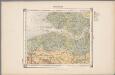
21. Walcheren, uit: Geologische kaart van Nederland / door W.C.H. Staring ; bew. aan de Topographische Inrichting
1 : 200000 Winand Carel Hugo Staring 1808-1877; Topographische Inrichting, 's-Gravenhage 's-Gravenhage : Belinfante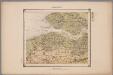
21. Walcheren, uit: Geologische kaart van Nederland : schaal van 1:200.000 / door W.C.H. Staring ; uitgevoerd door het Topographisch Bureau van Oorlog ; uitgegeven op last van Zijne Majesteit Den Koning
Annotatie: Impressum ontleend aan omslag; Kaart "Nederland de dijken weggedacht" [kaart 25] en kaart 13 (bladwijzer) vermelden het jaar 1869; Kaart 'Limburg en de Hesbaije' (bladnr. 26) vermeldt het jaar 1868; Blad 5/9 ontbreekt Topographische Inrichting, 's-Gravenhage; Topographisch Bureau Haarlem : A.C. Kruseman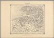
16, uit: Topografische atlas van het Koninkrijk der Nederlanden
Annotatie: Map met 19 losse krt. schaal 1:200.000 en 1 bladwijzer schaal 1:1.000.000 ['s-Gravenhage : Ministerie van Oorlog, Topografisch Bureau]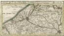
Brugge, Gent, Damme, Oostende, Schluys und andere Nah an liegende Staette Plaetze und Vestungen mitt deren Gegenden
1 : 250000 Mollova mapová sbírka Bodenehr, Gabriel Bodenehr, Gabriel
21me Middelburg, uit: Nouvelle carte de la Hollande, d'après Kraijenhoff et les meilleures cartes connues / Établissement Géographique de Bruxelles, fondé par Ph. Vander Maelen
1 : 117000 Annotatie: De bladen zijn genummerd 1-24. De bladen 2 t/m 24 hebben elk een afzonderlijke titel. Blad 5 bevat: Triangulations et positions. Blad 9 bevat: Plan d'Amsterdam; De kaartbladen 1, 5, 9 en 24 zijn niet ingekleurd; Van kaartblad 24 is een extra (ingekleurd) exempl. aanwezig; Annotatie geografische gegevens: 2 schaalstokken: 5 Echelle de 5 lieues de 20 au degré ... (= 23,2 cm) en 7380 Echelle de 5 lieues de 20 au degré ... (= 23,2 cm); Legenda; Met indexkaart: Carte d'assemblage Philippe Marie Guillaume Vander Maelen 1795-1869; Établissement Géographique de Bruxelles Bruxelles : Établissement Géographique
KAERTE | VAN | DE VIER AMBACHTEN
Gerard Coeck sculp. [Amsterdam : Joan Blaeu]
Flandriae partes duae, quarum altera proprietaria, altera imperialis vulgo dicitur
1 : 150000 Flandry Blaeu, Joan Guilj. et Joh. Blaeu
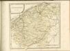
Franconatvs vulgo het Vrye
1 : 190000 Nizozemsko Blaeu, Joan Guiljelmus et Iohannes Blaeuw
Map of water supply: Ghent
1 : 100000 Series of maps on water supplies. Ghent. War Office
Carte topographique des rives de l'Escaut Occidental et du Canal de Gand à Terneuzen, indiquant les poldres, digues, écluses, waterinques ainsi que les limites des Flandres et de la Zélande
1 : 90000 par A.E.G. [= Albert Eugène Gheldolf] P.J. Doms fecit. Bruxelles : Ph. Vandermaelen
Flandriae Comitatus Pars Batava
1 : 133000 Mollova mapová sbírka Visscher, Nicolaes Schenk, Peter II
Flandriae comitatus pars Batava tam in ejusdem subjacentia quam vicina territoria
1 : 150000 accuratissima divisa per Nicolaum Visscher Amst. Bat. [Amsterdam] : nunc apud Petrum Schenk Iunior
Flandriae tevtonicae pars orientalior
1 : 190000 Flandry Blaeu, Joan Guiljelmus et Iohannes Blaeuw exc.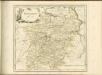

FLANDRIÆ | TEVTONICÆ | PARS ORIENTALIOR
Guilielmus et Iohannes Blaeuw exc. Amsterdami