Maps of Sint-Genesius-Rode

Plan parcellaire de la commune de Rhode-St-Genèse : avec les mutations
1 : 5000 Royal Library of Belgium Map Room Popp, Philippe Christian (1805-1879) Popp, Philippe Christian (1805-1879)
Plan parcellaire de la commune d'Alsemberg : avec les mutations
1 : 5000 Royal Library of Belgium Map Room Popp, Philippe Christian (1805-1879) Popp, Philippe Christian (1805-1879)
Plan parcellaire de la commune de Linkebeek : avec les mutations
1 : 5000 Royal Library of Belgium Map Room Popp, Philippe Christian (1805-1879) Popp, Philippe Christian (1805-1879)
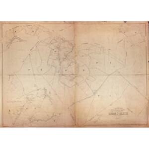
Plan parcellaire de la commune de Beersel : avec les mutations
1 : 2500 Royal Library of Belgium Map Room Popp, Philippe Christian (1805-1879) Popp, Philippe Christian (1805-1879)
Plan parcellaire de la commune de Braine-l'Alleud : avec les mutations
1 : 5000 Royal Library of Belgium Map Room Popp, Philippe Christian (1805-1879) Popp, Philippe Christian (1805-1879)
Plan parcellaire de la commune de Uccle : avec les mutations
1 : 5000 Royal Library of Belgium Map Room Popp, Philippe Christian (1805-1879) Popp, Philippe Christian (1805-1879)
Plan parcellaire de la commune de Waterloo : avec les mutations
1 : 5000 Royal Library of Belgium Map Room Popp, Philippe Christian (1805-1879) Popp, Philippe Christian (1805-1879)
Plan parcellaire de la commune de Hoeylaert : avec les mutations
1 : 5000 Royal Library of Belgium Map Room Popp, Philippe Christian (1805-1879) Popp, Philippe Christian (1805-1879)
Plan parcellaire de la commune de Tourneppe : avec les mutations
1 : 5000 Royal Library of Belgium Map Room Popp, Philippe Christian (1805-1879) Popp, Philippe Christian (1805-1879)
Carte particuliere des environs de Bruxelles et Vilvorden
1 : 163000 Brusel (Belgie) Covens & Mortier
Plan parcellaire de la commune de La Hulpe : avec les mutations
1 : 5000 Royal Library of Belgium Map Room Popp, Philippe Christian (1805-1879) Popp, Philippe Christian (1805-1879)
Die Schlacht bei La Belle-Alliance am 18ten Juny 1815
1 : 25000 Brügner, Carl; Brose, Karl Heinrich; Prêtre, Jean Gabriel Prêtre
Plan parcellaire de la commune de Leeuw-St-Pierre : avec les mutations
1 : 5000 Royal Library of Belgium Map Room Popp, Philippe Christian (1805-1879) Popp, Philippe Christian (1805-1879)
Plan parcellaire de la commune de Watermael-Boitsfort : avec les mutations
1 : 5000 Royal Library of Belgium Map Room Popp, Philippe Christian (1805-1879) Popp, Philippe Christian (1805-1879)
Plan parcellaire de la commune de Ohain : avec les mutations
1 : 5000 Royal Library of Belgium Map Room Popp, Philippe Christian (1805-1879) Popp, Philippe Christian (1805-1879)
Bataille de Mont Saint Jean.
1 : 60000 Melish, John
Plan parcellaire de la commune de Ruysbroeck : avec les mutations
1 : 2500 Royal Library of Belgium Map Room Popp, Philippe Christian (1805-1879) Popp, Philippe Christian (1805-1879)
Plan der glorreichen Schlacht bey la belle Alliance am 18ten Juny 1815
Waterloo (Belgie) Umpfenbach, Johann bey Fr. Wilmans
Plan parcellaire de la commune de Droogenbosch : avec les mutations
1 : 5000 Royal Library of Belgium Map Room Popp, Philippe Christian (1805-1879) Popp, Philippe Christian (1805-1879)
Carte routiere des environs de Bruxelles

Carte Particuliere des Environs de Bruxelles avec le Bois Soigne et d'une Partie de la Flandre jusques Agand
1 : 250000 Mollova mapová sbírka Seutter, Matthäus Lotter, Tobias Conrad Seutter, Matthäus
Carte Particuliere des environs de Bruxelles avec le Bois de Soigne et d'une partie de la Flandre jusques agand
1 : 116600 Mollova mapová sbírka Fricx, Eugène Henry Harrewyn, Jacques Fricx, Eugené Henry
Carte Particuliere des environs de Bruxelles, avec le Bois de Soigne, et d'un partie de la Flandre jusques a Gand
1 : 116600 Mollova mapová sbírka Fricx, Eugène Henry Covens, Johannes I
Carte particuliere des environs de Bruxelles avec le Bois de Soigne et d'une partie de la Flandre jusques a Gand
1 : 110000 Belgie Fricx, Eugene Henry chez Eugene Henry Friex
The Battle of Waterloo
Tyler Ackermann
Bruxellensis Tetrarchia
1 : 133000 Mollova mapová sbírka Visscher, Nicolaes Jansz. Schenk, Peter II
Brussels Water Supply Map
1 : 100000 First World War Brussels Water Supply Map. Shows location of standpipes, springs, wells etc. Numbered and notated. War Office
Map of Water Supply: Brussels
1 : 100000 Series of maps on water supplies. Brussels. War Office
SECVNDA PARS | BRABANTIÆ | cuius urbs primaria | BRVXELLÆ
Descr. Michaele Florentio a Langren | Mathematico Regio. Guiljelmus Blaeu excudit (scale cartouche)