Maps of Wavre

Plan parcellaire de la ville de Wavre : avec les mutations
1 : 5000 Royal Library of Belgium Map Room Popp, Philippe Christian (1805-1879) Popp, Philippe Christian (1805-1879)
Plan parcellaire de la commune de Bierges-Lez-Wavre : avec les mutations
1 : 5000 Royal Library of Belgium Map Room Popp, Philippe Christian (1805-1879) Popp, Philippe Christian (1805-1879)
Plan parcellaire de la commune de Limal : avec les mutations
1 : 5000 Royal Library of Belgium Map Room Popp, Philippe Christian (1805-1879) Popp, Philippe Christian (1805-1879)
Plan parcellaire de la commune de Ottenbourg : avec les mutations
1 : 5000 Royal Library of Belgium Map Room Popp, Philippe Christian (1805-1879) Popp, Philippe Christian (1805-1879)
Plan parcellaire de la commune de Dion-Le-Val : avec les mutations
1 : 5000 Royal Library of Belgium Map Room Popp, Philippe Christian (1805-1879) Popp, Philippe Christian (1805-1879)
Plan parcellaire de la commune de Dion-Le-Mont : avec les mutations
1 : 5000 Royal Library of Belgium Map Room Popp, Philippe Christian (1805-1879) Popp, Philippe Christian (1805-1879)
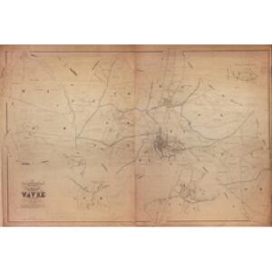
Ville de Wavre : développement de l'aggloméré
1 : 1250 Royal Library of Belgium Map Room Popp, Philippe Christian (1805-1879) Popp, Philippe Christian (1805-1879)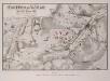
Treffen bei Wavre den 18/19ten Juny 1815
1 : 25000 Bock; Brose, Karl Heinrich; Prêtre, Jean Gabriel Prêtre
Plan parcellaire de la commune de Grez-Doiceau : avec les mutations
1 : 5000 Royal Library of Belgium Map Room Popp, Philippe Christian (1805-1879) Popp, Philippe Christian (1805-1879)
Plan parcellaire de la commune de Limelette : avec les mutations
1 : 5000 Royal Library of Belgium Map Room Popp, Philippe Christian (1805-1879) Popp, Philippe Christian (1805-1879)
Plan parcellaire de la commune de Archennes : avec les mutations
1 : 5000 Royal Library of Belgium Map Room Popp, Philippe Christian (1805-1879) Popp, Philippe Christian (1805-1879)
Plan parcellaire de la commune de Rhode-Ste-Agathe : avec les mutations
1 : 5000 Royal Library of Belgium Map Room Popp, Philippe Christian (1805-1879) Popp, Philippe Christian (1805-1879)
Plan parcellaire de la commune de Over-Yssche : avec les mutations
1 : 5000 Royal Library of Belgium Map Room Popp, Philippe Christian (1805-1879) Popp, Philippe Christian (1805-1879)
Plan parcellaire de la commune de Bossut-Gottechain : avec les mutations
1 : 5000 Royal Library of Belgium Map Room Popp, Philippe Christian (1805-1879) Popp, Philippe Christian (1805-1879)
Plan parcellaire de la commune de Corroy-Le-Grand : avec les mutations
1 : 5000 Royal Library of Belgium Map Room Popp, Philippe Christian (1805-1879) Popp, Philippe Christian (1805-1879)
Plan parcellaire de la commune de Ottignies : avec les mutations
1 : 5000 Royal Library of Belgium Map Room Popp, Philippe Christian (1805-1879) Popp, Philippe Christian (1805-1879)
Plan parcellaire de la commune de Rosières : avec les mutations
1 : 2500 Royal Library of Belgium Map Room Popp, Philippe Christian (1805-1879) Popp, Philippe Christian (1805-1879)
Plan parcellaire de la commune de Rixensart : avec les mutations
1 : 5000 Royal Library of Belgium Map Room Popp, Philippe Christian (1805-1879) Popp, Philippe Christian (1805-1879)
Plan parcellaire de la commune de Huldenbergh : avec les mutations
1 : 5000 Royal Library of Belgium Map Room Popp, Philippe Christian (1805-1879) Popp, Philippe Christian (1805-1879)
Plan parcellaire de la commune de Bonlez : avec les mutations
1 : 5000 Royal Library of Belgium Map Room Popp, Philippe Christian (1805-1879) Popp, Philippe Christian (1805-1879)
Carte Partic. des Envir. de Louvain Aerschot, Diest, Tirlemont, Leau, Iudogne, Malines, et de Partie du Pays de Liege
1 : 250000 Mollova mapová sbírka Seutter, Matthäus Lotter, Tobias Conrad Seutter, Matthäus
Carte Particuliere des Environs de Louvain, Aerschot, Diest, Tirlemont, Leau, Iudogne, Malines, et de Partie du Pays de Liege
1 : 116600 Mollova mapová sbírka Fricx, Eugène Henry Covens, Johannes I
Carte particuliere des environs de Louvain, Aerschot, Diest, Tirlemont, Leau, Iudogne, Malines, et de partie du Pays de Liege
1 : 110000 Aarschot (Belgie) Fricx, Eugene Henry chez Eugene Henry Friex
Carte particulière des environs de Louvain, Aerschot, Diest, Tirlemont, Leau, Iudogne, Malines, et de partie du Pays de Liège
1 : 110000 A Bruxelles : chez Eugene Henry Friex, rue de la Madelène
The Battle of Waterloo
Tyler Ackermann
Prima Pars Brabantiae cuius caput Lovanium
1 : 135000 auctore Michaele Florentio a Langren Guiljelmus Blaeu excudit [Amsterdam] : [Blaeu]
Bruxellensis Tetrarchia
1 : 133000 Mollova mapová sbírka Visscher, Nicolaes Jansz. Schenk, Peter II
PRIMA PARS | BRABANTIÆ | cuius caput | LOVANIVM
Auctore | Michaele Florentio a Langren | Hispan. regis mathematico. Guiljelmus Blaeu excudit