Maps of Nivelles

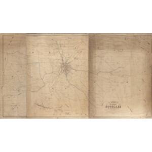
Plan parcellaire de la ville de Nivelles : avec les mutations
1 : 5000 Royal Library of Belgium Map Room Popp, Philippe Christian (1805-1879) Popp, Philippe Christian (1805-1879)
Plan parcellaire de la commune de Arquennes : avec les mutations
1 : 2500 Royal Library of Belgium Map Room Popp, Philippe Christian (1805-1879) Popp, Philippe Christian (1805-1879)
Plan parcellaire de la commune de Baulers : avec les mutations
1 : 5000 Royal Library of Belgium Map Room Popp, Philippe Christian (1805-1879) Popp, Philippe Christian (1805-1879)
Plan parcellaire de la commune de Monstreux : avec les mutations
1 : 5000 Royal Library of Belgium Map Room Popp, Philippe Christian (1805-1879) Popp, Philippe Christian (1805-1879)
Plan parcellaire de la commune de Thines lez-Nivelles : avec les mutations
1 : 5000 Royal Library of Belgium Map Room Popp, Philippe Christian (1805-1879) Popp, Philippe Christian (1805-1879)
Plan parcellaire de la commune de Petit-Roeulx lez-Nivelles : avec les mutations
1 : 5000 Royal Library of Belgium Map Room Popp, Philippe Christian (1805-1879) Popp, Philippe Christian (1805-1879)
Ville de Nivelles : développement de l'aggloméré
1 : 1000 Royal Library of Belgium Map Room Popp, Philippe Christian (1805-1879) Popp, Philippe Christian (1805-1879)
Plan parcellaire de la commune de Bornival : avec les mutations
1 : 5000 Royal Library of Belgium Map Room Popp, Philippe Christian (1805-1879) Popp, Philippe Christian (1805-1879)
Plan parcellaire de la commune de Buzet : avec les mutations
1 : 5000 Royal Library of Belgium Map Room Popp, Philippe Christian (1805-1879) Popp, Philippe Christian (1805-1879)
Plan parcellaire de la commune de Lillois : avec les mutations
1 : 5000 Royal Library of Belgium Map Room Popp, Philippe Christian (1805-1879) Popp, Philippe Christian (1805-1879)
Plan parcellaire de la commune de Obaix : avec les mutations
1 : 5000 Royal Library of Belgium Map Room Popp, Philippe Christian (1805-1879) Popp, Philippe Christian (1805-1879)
Plan parcellaire de la commune de Feluy : avec les mutations
1 : 5000 Royal Library of Belgium Map Room Popp, Philippe Christian (1805-1879) Popp, Philippe Christian (1805-1879)
Plan parcellaire de la commune de Houtain-Le-Val : avec les mutations
1 : 5000 Royal Library of Belgium Map Room Popp, Philippe Christian (1805-1879) Popp, Philippe Christian (1805-1879)
Plan parcellaire de la commune de Rèves : avec les mutations
1 : 5000 Royal Library of Belgium Map Room Popp, Philippe Christian (1805-1879) Popp, Philippe Christian (1805-1879)
Plan parcellaire de la commune de Haut-Ittre : avec les mutations
1 : 5000 Royal Library of Belgium Map Room Popp, Philippe Christian (1805-1879) Popp, Philippe Christian (1805-1879)
Plan parcellaire de la commune de Ittre : avec les mutations
1 : 5000 Royal Library of Belgium Map Room Popp, Philippe Christian (1805-1879) Popp, Philippe Christian (1805-1879)
Plan parcellaire de la commune de Seneffe : avec les mutations
1 : 5000 Royal Library of Belgium Map Room Popp, Philippe Christian (1805-1879) Popp, Philippe Christian (1805-1879)
Plan parcellaire de la commune de Vieux-Genappe : avec les mutations
1 : 5000 Royal Library of Belgium Map Room Popp, Philippe Christian (1805-1879) Popp, Philippe Christian (1805-1879)
Plan parcellaire de la commune de Op-Hain : avec les mutations
1 : 5000 Royal Library of Belgium Map Room Popp, Philippe Christian (1805-1879) Popp, Philippe Christian (1805-1879)
Plan parcellaire de la commune de Loupoigne : avec les mutations
1 : 5000 Royal Library of Belgium Map Room Popp, Philippe Christian (1805-1879) Popp, Philippe Christian (1805-1879)
Plan parcellaire de la commune de Ronquières : avec les mutations
1 : 5000 Royal Library of Belgium Map Room Popp, Philippe Christian (1805-1879) Popp, Philippe Christian (1805-1879)
The Battle of Waterloo
Tyler Ackermann
Carte particuliere des environs de Mons, d'Ath, de Charleroy, de Maubeuge, du Quesnoy, de Conde, et autres
1 : 110000 Ath (Belgie) Fricx, Eugene Henry Harrewyn, Jacques chez Eugene Henry Fricx
Bruxellensis Tetrarchia
1 : 133000 Mollova mapová sbírka Visscher, Nicolaes Jansz. Schenk, Peter II
Brussels Water Supply Map
1 : 100000 First World War Brussels Water Supply Map. Shows location of standpipes, springs, wells etc. Numbered and notated. War Office
Map of Water Supply: Brussels
1 : 100000 Series of maps on water supplies. Brussels. War Office
XIII ; 3.K., uit: Carte chorographique des Pays-Bas Autrichiens / ... par le Comte de Ferraris ; gravée par L.A. Dupuis
1 : 86400 Annotatie: Bladen linksboven genummerd met Romeinse cijfers, rechtsboven met een cijfer en een letter; Met opdracht aan keizer Joseph II (bl.XVI); Met plattegrond van Brussel (bl. XXI), overzichtskaart (bl. XXII) en bladwijzer (bl. XXIII); Annotatie geografische gegevens: Schaalstokken: Echelle de Toises ou de Lieues communes de France; Echelle de Verges ou de Lieues de Brabant; Echelle de Milles d'Allemagne (bl. XVII); Echelle de Mètres; In de hoeken lengte- en breedtematen T.M.e en T.P.e Joseph-Jean François Ferraris Comte de 1726-1814; L.A. Dupuis [S.l. : s.n.]
XIII, uit: Carte chorographique des Pays-Bas Autrichiens / ... par le Comte de Ferraris ; gravée par L.A. Dupuis
1 : 86400 Annotatie: Lit.: Les militaires et la cartographie des Pays-Bas méridionaux et de la Principauté de Liège à la fin du XVIIe et au XVIII siècle / Claire Lemoine-Isabeau. - Bruxelles, 1984, p. 206-212; La cartographie au XVIIIe siècle et l'oeuvre du Comte de Ferraris (1726-1814) : colloque international, Spa, 8-11 sept. 1976. - Bruxelles, 1978; Met opdracht aan keizer Joseph II (bl.XVI); Met plattegrond van Brussel (bl. XXI), overzichtskaart (bl. XXII) en bladwijzer (bl. XXIII); Ontbreekt: bl. I-III en XXI; Voor aanwezige bladen zie overzichtsblad Ferraris, Johann Joseph; Dupuis, L. A. [S.l. : s.n.]
SECVNDA PARS | BRABANTIÆ | cuius urbs primaria | BRVXELLÆ
Descr. Michaele Florentio a Langren | Mathematico Regio. Guiljelmus Blaeu excudit (scale cartouche)