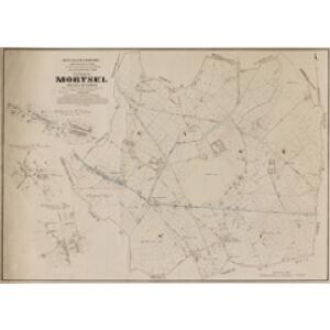
Maps of Mortsel

Plan parcellaire de la commune de Mortsel : avec les mutations
1 : 5000 Royal Library of Belgium Map Room Popp, Philippe Christian (1805-1879) Popp, Philippe Christian (1805-1879)
Plan bijou de l'Exposition universelle
Antverpy (Belgie) Bertels, C.-H. H. Vankerkhoven
[Plán neznámého města]
Evropa Bodenehr, Gabriel Bertels, C.-H.
Plan parcellaire de la commune de Berchem lez-Anvers : avec les mutations
1 : 5000 Royal Library of Belgium Map Room Popp, Philippe Christian (1805-1879) Popp, Philippe Christian (1805-1879)
Plan parcellaire de la commune de Edeghem : avec les mutations
1 : 5000 Royal Library of Belgium Map Room Popp, Philippe Christian (1805-1879) Popp, Philippe Christian (1805-1879)
Plan parcellaire de la commune de Borsbeeck (lez Anvers) : avec les mutations
1 : 5000 Royal Library of Belgium Map Room Popp, Philippe Christian (1805-1879) Popp, Philippe Christian (1805-1879)
[Kaart], uit: Nieuw plan van Antwerpen, voorsteden en dokken : met aanduiding der kaainummers
1 : 12500 titelvariant: Antwerpen; Annotatie: Omslagtitel: Antwerpen : gids Brabo ... Antwerpen : Stappaers
Marchionatus Sacri Romani Imperii. [Karte], in: Novus atlas absolutissimus, Bd. 3, S. 55.
1 Karte aus Atlas Janssonius Offizin
Plan de la ville d'Anvers et ses environs
1 : 9300 Richard Huybrechts & Cie. Editeurs chez Rich[ar]d Huybrechts & cie. editeurs
Nouveau plan de la ville d'Anvers / dressé par A. Scheepers
1 : 10000 Scheepers, A.
Plan parcellaire de la commune de Wilryck : avec les mutations
1 : 5000 Royal Library of Belgium Map Room Popp, Philippe Christian (1805-1879) Popp, Philippe Christian (1805-1879)
Plan der Stadt und Citadelle von Antwerpen
Antverpy (Belgie) Tardieu, Auguste Ambroise Industrie Comptoir
Antwerpen

Plan parcellaire de la commune de Bouchout (lez Lierre) : avec les mutations
1 : 5000 Royal Library of Belgium Map Room Popp, Philippe Christian (1805-1879) Popp, Philippe Christian (1805-1879)
Marchionatus Sacri Romani Imperii
1 : 21000 C.J. Visscher excudebat [Amsterdam] : nunc apud Petrum Schenk Junior
Marchionatus Sacri Romani Imperii / [C.J. Visscher]
1 : 60000 Annotatie: Origineel is Blad 44 in atlas factice; Met kaartje van de omgeving, afbeeldingen van de voornaamste gebouwen en 3 panorama's; Annotatie geografische gegevens: Oost boven Visscher, Claes Jansz. [Amsterdam : C.J. Visscher excudebat]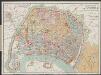
Plan-guide d'Anvers
1 : 12500 Librairie Ackermann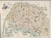
[Recto], uit: Plan instantané de la ville d'Anvers : indiquant les principaux monuments en relief, le tracé des tramways, les nouveaux quais, hangars, etc., etc. / dressé par E.V.D.H.
1 : 11600 E.V.D.H. Anvers : Huybrechts
Plan parcellaire de la commune de Hove lez-Contich : avec les mutations
1 : 5000 Royal Library of Belgium Map Room Popp, Philippe Christian (1805-1879) Popp, Philippe Christian (1805-1879)
Plan parcellaire de Deurne (lez-Anvers) : avec les mutations
1 : 5000 Royal Library of Belgium Map Room Popp, Philippe Christian (1805-1879) Popp, Philippe Christian (1805-1879)
Marchionatus Sacri Romani Imperii : Nobilißimo, Amplißimo, Prudentißimoq[ue] Senatuj Urbis Antverpiæ, nec non Marchionatus Sacri Imperij, Viris Consultissimis Sapientissimisq[ue]
Visscher, Nicolaes, 1618-1679 Nicolaus Jansenius Piscator
Karte der Umgebung von Antwerpen
Antverpy (Belgie)
Carte des environs d'Anvers
1 : 100000 Dordt : by Steuerwald & Co. ; Breda : bij Broese & Co.
55 Hulst, uit: Topographische en militaire kaart van het Koningrijk der Nederlanden / vervaardigd door de officieren van den Generale Staf ; en gegraveerd op het Topographisch Bureau, van het Ministerie van Oorlog
1 : 50000 titelvariant: TMK; Annotatie: Met bladwijzer op schaal 1:600.000. - 1915; Met Verklaring van de topographische en militaire kaart van het Koninkrijk der Nederlanden. - 1910; Bd. 1: titelblad, bladwijzer, verklaring, bladen 1 t/m 32; Bd. 2: bladen 33 t/m 62 Generale Staf, Nederland; Ministerie van Oorlog. Topographisch Bureau ['s-Gravenhage : Ministerie van Oorlog]
De Schelde van Antwerpen tot Bath
1 : 90000 steendr. v. C. Magnenat Amsterdam : Frans Buffa & Zonen [...]
Tertia Pars Brabantiae qua continetur Marchionat. S.R.I. horum urbs primaria Antverpia
1 : 180000 Mollova mapová sbírka Langren, Michael Florent van Bleau, Willem Janszon
Antwerpen u. Umgegend
1 : 100000 L. Friederichsen & Co.
Carte tres-particuliere du Pays de Waes
1 : 120000 Antverpy (Belgie) Fricx, Eugene Henry chez Eugene Henry Fricx
Carte particuliere des Environs d'Anvers. Gand Hulst. et de tout le Pays de Waes
1 : 116600 Mollova mapová sbírka Fricx, Eugène Henry Harrewyn, Jacques Fricx, Eugené Henry