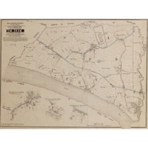
Maps of Hemiksem

Plan parcellaire de la commune de Hemixem : avec les mutations
1 : 5000 Royal Library of Belgium Map Room Popp, Philippe Christian (1805-1879) Popp, Philippe Christian (1805-1879)
Plan parcellaire de la commune de Schelle : avec les mutations
1 : 5000 Royal Library of Belgium Map Room Popp, Philippe Christian (1805-1879) Popp, Philippe Christian (1805-1879)
Plan parcellaire de la commune de Basel : avec les mutations
1 : 5000 Royal Library of Belgium Map Room Popp, Philippe Christian (1805-1879) Popp, Philippe Christian (1805-1879)
Plan parcellaire de la commune de Hoboken : avec les mutations
1 : 5000 Royal Library of Belgium Map Room Popp, Philippe Christian (1805-1879) Popp, Philippe Christian (1805-1879)
Plan parcellaire de la commune de Wilryck : avec les mutations
1 : 5000 Royal Library of Belgium Map Room Popp, Philippe Christian (1805-1879) Popp, Philippe Christian (1805-1879)
Plan parcellaire de la commune de Cruybeke : avec les mutations
1 : 5000 Royal Library of Belgium Map Room Popp, Philippe Christian (1805-1879) Popp, Philippe Christian (1805-1879)
Plan parcellaire de la commune de Aertselaer : avec les mutations
1 : 5000 Royal Library of Belgium Map Room Popp, Philippe Christian (1805-1879) Popp, Philippe Christian (1805-1879)
Karte der Umgebung von Antwerpen
Antverpy (Belgie)
Carte des environs d'Anvers
1 : 100000 Dordt : by Steuerwald & Co. ; Breda : bij Broese & Co.
Carte particuliere des environs de Lier et de Malines
1 : 163000 Lier (Belgie) Covens & Mortier
WASIA. | 'T Land van Waes
[Amsterdam : Joan Blaeu]
Carte tres-particuliere du Pays de Waes, ou sont marqués les Lignes depuis Anvers jusques a Gand
1 : 116600 Mollova mapová sbírka Fricx, Eugène Henry Harrewyn, Jacques Fricx, Eugené Henry
Carte Particuliere des Environs d'Anvers, Gand, Hulst, et de tout le Pays de Waes, et le Marquisat du St. Empire
1 : 116600 Mollova mapová sbírka Fricx, Eugène Henry Covens, Johannes I
Antwerpen u. Umgegend
1 : 100000 L. Friederichsen & Co.
Carte Particul. des Environs d'Anvers, Gand, Hulst, et de tout le Pays de Waes. et la Marquisat du St. Empire
1 : 250000 Mollova mapová sbírka Seutter, Matthäus Lotter, Tobias Conrad Seutter, Matthäus
Carte tres-particuliere du Pays de Waes
1 : 120000 Antverpy (Belgie) Fricx, Eugene Henry chez Eugene Henry Fricx
Carte particuliere des Environs d'Anvers. Gand Hulst. et de tout le Pays de Waes
1 : 116600 Mollova mapová sbírka Fricx, Eugène Henry Harrewyn, Jacques Fricx, Eugené Henry
Carte particuliere des environs d'Anvers, Gand, Hulst, et de tout le Pays de Waes
1 : 106000 Antverpy (Belgie) Fricx, Eugene Henry Harrewyn, Jacques chez Eugene Henry Friex
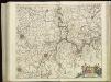
S.R.I. sive Antverpiae Marchionatus, et Dominium Mechliniae
1 : 100000 Mollova mapová sbírka Allard, Carel Covens, Johannes I
Mechalinia Dominum et Aerschot Ducatus
1 : 266000 Mollova mapová sbírka Visscher, Nicolaes Schenk, Peter II
KAERTE | VAN | DE VIER AMBACHTEN
Gerard Coeck sculp. [Amsterdam : Joan Blaeu]
Road and Bridge Map: Antwerp
1 : 100000 First World War Road and Bridge Map. Antwerp. Showing roads normally suitable for motor traffic, road bridges and light railways. War Office
VIII ; 2.K., uit: Carte chorographique des Pays-Bas Autrichiens / ... par le Comte de Ferraris ; gravée par L.A. Dupuis
1 : 86400 Annotatie: Bladen linksboven genummerd met Romeinse cijfers, rechtsboven met een cijfer en een letter; Met opdracht aan keizer Joseph II (bl.XVI); Met plattegrond van Brussel (bl. XXI), overzichtskaart (bl. XXII) en bladwijzer (bl. XXIII); Annotatie geografische gegevens: Schaalstokken: Echelle de Toises ou de Lieues communes de France; Echelle de Verges ou de Lieues de Brabant; Echelle de Milles d'Allemagne (bl. XVII); Echelle de Mètres; In de hoeken lengte- en breedtematen T.M.e en T.P.e Joseph-Jean François Ferraris Comte de 1726-1814; L.A. Dupuis [S.l. : s.n.]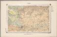
22. Kempen, uit: Geologische kaart van Nederland / door W.C.H. Staring ; bew. aan de Topographische Inrichting
1 : 200000 Winand Carel Hugo Staring 1808-1877; Topographische Inrichting, 's-Gravenhage 's-Gravenhage : Belinfante
MECHLINIA | DOMINIVM, | et | AERSCHOT | DVCATVS
Auctore Michaele Flor. a Langren | Regis Catholici mathematico. [Amsterdam : Joan Blaeu]
MECHLINIA | DOMINIVM, | et | AERSCHOT | DVCATVS
Auctore Michaele Flor. a Langren | Regis Catholici mathematico. [Amsterdam : Joan Blaeu]
Marchionatus sacri imperii et dominii Mechelini tabula
1 : 115000 auctore F. de Wit. Gedruckt tot Amsterdam : by Frederick de Wit, in de Kalverstraet inde Witte Paskaert
Mechlinia Dominium, et Aerschot Ducatus. [Karte], in: Novus Atlas, das ist, Weltbeschreibung, Bd. 1, S. 374.
1 Karte aus Atlas Blaeu, Joan Blaeu, Willem Janszoon
Carte topographique des rives de l'Escaut Occidental et du Canal de Gand à Terneuzen, indiquant les poldres, digues, écluses, waterinques ainsi que les limites des Flandres et de la Zélande
1 : 90000 par A.E.G. [= Albert Eugène Gheldolf] P.J. Doms fecit. Bruxelles : Ph. Vandermaelen