Maps of Nordreisa

Krokering nr 67
1 : 100000 Morgenstierne
1734-3 Reisadalen
1 : 50000 Statens kartverk
1734-3 Reisadalen
1 : 50000 Statens kartverk
1734-3 Reisadalen
1 : 50000 Norges Geografiske Oppmåling
1734-3 Reisadalen
1 : 50000 Statens kartverk
Krokering nr 16
1 : 100000 Lund
1734-2 Kvænangsbotn
1 : 50000 Statens kartverk
1734-2 Kvænangsbotn
1 : 50000 Statens kartverk
1734-2 Kvænangsbotn
1 : 50000 Statens kartverk
1734-2 Kvænangsbotn
1 : 50000 Norges Geografiske Oppmåling
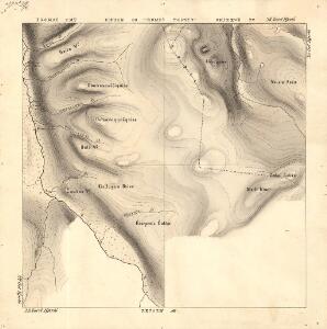
Krokering nr 81
1 : 200000 Morgenstierne
Krokering nr 72
1 : 200000 Lund
Krokering nr 73
1 : 200000 Lund
Krokering nr 21
1 : 100000 Lund
Krokering nr 36
1 : 100000 Lund
1733-4 Raisduoddar-hal'di
1 : 50000 Norges Geografiske Oppmåling
1733-4 Raisduoddar-hal'di
1 : 50000 Norges Geografiske Oppmåling
1733-4 Ráisduottarháldi
1 : 50000 Statens kartverk
1733-4 Raisduottarháldi
1 : 50000 Statens kartverk
Krokering nr 66
1 : 100000 Morgenstierne
1733-1 Mållešjåkka
1 : 50000 Norges Geografiske Oppmåling
1733-1 Mollešjohka
1 : 50000 Statens kartverk
1733-1 Mollešjohka
1 : 50000 Statens kartverk
Krokering nr 37
1 : 100000 Lund
Geologiske kart 121-Z: Kart med magnetisk totalfelt. Nordreisa
1 : 250000 Norges geologiske undersøkelse
Statistikk 36-3 sør: Ethnigrafisk Kart over Finmarkens Amt No 3
1 : 200000 Jens Andreas Friis
Statistikk 43-27-2: Bosettingskart over Nordreisa. Blad 27
1 : 250000 Statistisk Sentralbyrå
Statistikk 43-27- Bosettingskart over Nordreisa. Blad 27
1 : 250000 Statistisk Sentralbyrå
Krokering nr 38-2
1 : 100000 Lund