Maps of Hordaland
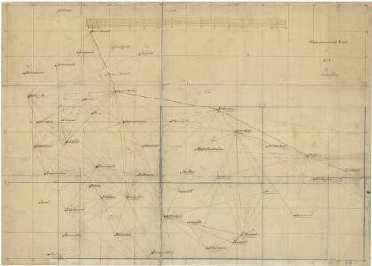
Trigonometrisk grunnlag, Squelet-Cart 54: Trigonometrisk Kart for 1856
Johannes Falkenberg
[Kart over Sondre Trondhjems Amt]
1 : 200000 Norsko Bjune, Carl Geografiske opmaaling
VII
1 : 400000 L. Arentz
Spesielle kart 19: Oversigtskart over den pojecterede Jernbanelinie mellem Bergen og Vossevangen
1 : 200000
Statistikk 43-6-2: Bosettingskart over Norge. Blad 6
1 : 250000 Statistisk Sentralbyrå
Trigonometrisk grunnlag, Squelet-Cart 57: Trigonometrisk Kart
1 : 200000 H. Gill
Kartblad 136: Situations-Cart over det Nordre Hardangerske Compagnie District
Lauritz Brix Grøn
Museumskart 89:Speciel Kaart over en Deel af Den Norske Kyst, Bergen og Fedje
1 : 70000 Carl Frederik Grove
Statistikk 43-6- Bosettingskart over Norge. Blad 6
1 : 250000 Statistisk Sentralbyrå
Museumskart 217-57: Specialkart over Sognefjorden
1 : 100000 G. Dellinger Den Geografiske Opmaaling
Museumskart 90: Speciel Kaart over en Deel af Den Norske Kyst
1 : 50000 Carl Frederik Grove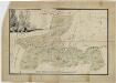
Kartblad 133: Udkast til et Situations-Cart over Wosse Compagnie District
Carl von Kühle
Kartblad 132-2: Situation af det Urlandske Compagnie District; versjon 2
Leitzner
Kartblad 132- Situation af det Urlandske Compagnie District; versjon 1
Leitzner
Kartblad 126: Wej- og Situations_cart over det Tjugumske Compagnie District
Gerhard Heiberg Daae
Portefølje nr 34
1 : 100000 E. Lund
Museumskart 217-32: Kart over Den Norske Kyst fra Korsfjord til Hellisø
1 : 50000 Den Geografiske Opmaaling
Portefølje nr 35
1 : 100000
C33-4; C33-5; C34-10; C34-11
1 : 100000 Johannes Oliver Smith
23A Voss
1 : 100000 Johan Gulbrandsen Natrud
Kartblad 129: Situations Cart over det Nordre Sündhordlehnske Compagnie District
Severin Wincentz Segelcke
Geologiske kart 63: Den geologiske Undersøgelse, Voss
1 : 100000 J. Natrud Norges geologiske undersøkelse
Kartblad 135: Cart over det Mellem Nordhordlehnske Compagnie District
Hendrik Miltzau Dahl
16D Bergen
1 : 100000 H. C. Wanggård | E. Heiberg | H. Bergh
16D Bergen
1 : 100000 H. C. Wanggård | H. Bergh | E. Heiberg
16D Bergen
1 : 100000 Einar Sigurd Ween | H. Bergh | E. Heiberg
16D Bergen
1 : 100000 H. Bergh | E. Heiberg | Einar Sigurd Ween
Museumskart 82: Hardangerfjorden
1 : 100000
Portefølje nr 36
1 : 100000 H. Lund