Maps of Ringsaker
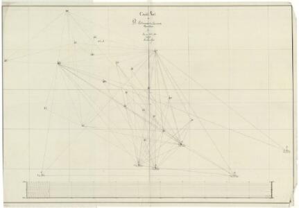
Trigonometrisk grunnlag, dublett 29- Kart over trigonometriske punkter foretatt i 1807 og 1810
Hans Lemmich Juell
Trigonometrisk grunnlag, Squelet-Cart 29: Skelet-kart over Oppland og Hedmark 1807 og 1810
Hans Lemmich Juell
Trigonometrisk grunnlag, dublett 29-2: Kart over trigonometriske punkter foretatt i 1807 og 1810
Hans Lemmich Juell
25D Lillehammer
1 : 100000 Einar Sigurd Ween | Johan Ferdinand Normann
5527 Lillehammer
1 : 100000
25D Lillehammer
1 : 100000 Johan Ferdinand Normann
25D Lillehammer
1 : 100000 Einar Sigurd Ween | Johan Ferdinand Normann
25D Lillehammer
1 : 100000 Johan Ferdinand Normann
25D Lillehammer
1 : 100000 Johan Ferdinand Normann | Ole Engh
F31 aust Synnfjell
1 : 100000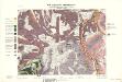
Geologisk kart 32b: Den Geologiske Undersøgelse, Rektangel 26 Åmot
1 : 100000 Øgaard | Ths. Münster | P. Krohn Norges geologiske undersøkelse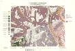
Geologisk kart 32a: Den Geologiske Undersøgelse, Rektangel 26 Åmot
1 : 100000 P. Krohn | Ths. Münster | Øgaard Norges geologiske undersøkelse
Kartblad 52: Militært Cart over det Gusdalske Compagnies District
Keilhau
F31 aust Synnfjell
1 : 100000
F31 aust Synnfjell
1 : 100000
25D Lillehammer
1 : 100000
1817-3 Follebu
1 : 50000 Norges Geografiske Oppmåling
1817-2 Lillehammer
1 : 50000 Statens kartverk
1817-2 Lillehammer
1 : 50000 Statens kartverk
1817-3 Follebu
1 : 50000 Statens kartverk
Kartblad 5 Vey-Cart over det Nordre Hedemarkiske Capt. Von Weyhes Compagnie District
Johan Henrik Ramm
1917-3 Åsmark
1 : 50000 Statens kartverk
1817-2 Lillehammer
1 : 50000 Statens kartverk
25D Lillehammer
1 : 100000
1817-2 Lillehammer
1 : 50000 Norges Geografiske Oppmåling
G31-1; G31-2; G31-3; G31-4; G31-8; G31-9; G31-10
1 : 50000 Erling Bjørstad
Kartblad 62: Charte over det Faabergske Compagnie District

F31 aust Synnfjell
1 : 100000
F31 aust Synnfjell
1 : 100000