Maps of Nes
Trigonometrisk grunnlag, vedlegg 59
1 : 50000
Geologisk kart 39: Den Geologiske Undersøgelse, Nannestad
1 : 100000 Norges geologiske undersøkelse
20A Nannestad
1 : 100000 Johan Ferdinand Nordmann | Ole Engh
Geologisk kart 10 Nannestad
1 : 100000
Kart over iernbanelinie fra Christiania til à ̃ieren og Mjà ̧sen, tilligmed Vandlinien fra à ̃ieren til Mjà ̧sen
1 : 20000 Holcks Attelier
20A Nannestad
1 : 100000 Johan Ferdinand Normann | Carl Christian Olberg
20A Nannestad
1 : 100000 Carl Christian Olberg | Johan Ferdinand Normann
Geologiske kart 30: Den geologiske Undersøgelse, Nannestad
1 : 100000 T. Ch. Thomassen | Normann | Johan H. L. Vogt Norges geologiske undersøkelse
Kartblad 42: Vej-Cort over det Ullensagerske Compagnies District (Under Norske Jægerkorps)
C. Hals
20A Nannestad
1 : 100000 Johan Ferdinand Normann | Carl Christian Olberg
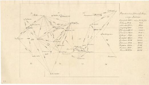
Trigonometrisk grunnlag, vedlegg 53: Kart over endeel Triangler
1 : 50000 N. S. Darre
Kartblad 24: Wei-Kaart over det Schijedsmoiske Compagnie District
Lihme senior
Kartblad 43: Wej-Cart over det Næsiske lette Infanterie Compagnies District

Ekserserplasskart; Gardermoen sydlig blad
1 : 50000
20A Nannestad
1 : 100000 Johan Ferdinand Normann | Carl Christian Olberg
20A Nannestad
1 : 100000 Johan Ferdinand Normann | Carl Christian Olberg
Spesielle kart 104-1: Kart over Fredrikshaldsvassdraget med Mangenvassdraget
1 : 50000 Finn Qvale
20A Nannestad
1 : 100000 Johan Ferdinand Nordmann | Ole Engh
G35-11
1 : 50000 N. Houge
1915-3 Nannestad
1 : 50000 Statens kartverk
1915-2 Ullensaker
1 : 50000 Statens kartverk
1915-3 Nannestad
1 : 50000 Statens kartverk
1915-3 Nannestad
1 : 50000 Statens kartverk
1915-2 Ullensaker
1 : 50000 Norges Geografiske Oppmåling
1915-2 Ullensaker
1 : 50000 Norges Geografiske Oppmåling
Trigonometrisk grunnlag, vedlegg 22: Kvadratmilien No 97, kvadratmilen No 58
1 : 10000
2015-3 Strøm
1 : 50000
2015-3 Ström
1 : 50000 Statens kartverk
Trigonometrisk grunnlag, vedlegg 15: Fundament Mensul for Sammenbindelsen af de gamle Operationer
1 : 50000 Hans Lemich Juell | Johan Henrik Ramm