Maps of Gagauzia

Maps of Gagauzia

$title$

Trigonometrisk grunnlag, vedlegg 65, 2-5: Grunnlagspunkter for Struves meridianbue fra Bessarabia og Volhynia
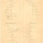
1 : 200000 de Tenner
$title$

Republik Moldau 1989. Ethnische Zusammensetzung der Bevölkerung - Bulgaren

Moldawien ethnische Gruppe, Bulgaren Hofinger, Veronika
$title$

Republik Moldau 1989. Ethnische Zusammensetzung der Bevölkerung - Gagausen

Moldawien ethnische Gruppe, Gagausen Hofinger, Veronika
$title$

Carte de la Roumanie et pays limitrophes. Odessa

1 : 500000 France. Service géographique de l'armée [Paris] : Service géographique de l'armée
$title$

Plan des tapfern Angriffs und vollkommenen Sieges der russisch-kayserlichen Waffen über die Turkische und Tatarische Arméé an der Large in der Moldau den 7. Iuly 1770

1 : 40000 Moldavsko
$title$

Generalkarte von Zentraleuropa

$title$

Russisch türkischer Kriegsschauplatz in Europa

1 : 584000 Dunaj-delta (Rumunsko a Ukrajina) Alois Hynek
$title$

Italien und Balkanhalbinsel. Nebenkarten II. 4. Donaudelta

Donaudelta
$title$

Transnistrien 1989. Ethnische Zusammensetzung der Bevölkerung - Moldauer (Rumänen)

Transnistrien ethnische Gruppe, Moldauer Hofinger, Veronika
$title$

Ostia Danubij

Mollova mapová sbírka Hoffmann, Johannes Hoffmann, Johann
$title$

Donaudelta

1 : 5000000 Donaudelta
$title$

Mačinski budžak

1 : 300000 Rumänien Dobrudscha
$title$

[Donaudelta bei Sulina : Russ. Militäroperation]

Rumänien Sulina Russisch-Türkischer Krieg <1877-1878>
$title$

Plan preslědovanija za neprijatelem korpusom gospodina generala kvartermistra Bauera, do rěki Dunaja 21. julja v četvertago času po poludni iz zanjatago lagerja po pobědě nad neprijatelem pri rječki Kagulě, na kotorom naznačen i prežnej retrašament neprijatelskoj 1770 godu julja 23. dnja

1 : 7500 Besarábie (Moldavsko a Ukrajina)
$title$

Plan dviženii ataki i soveršennoj pobědy oderžannoj vojskami Jeja Imperatorskago Veličestva nad Turkami pod komandoju ver'chovnago vizirja v Bessarabii pri rěčkě Kagulě 1770 goda ijulja 21. dnja

1 : 21000
$title$

Lagerăt na Ispericha Ogăl

1 : 100000 Rumänien Dobrudscha
$title$

Plan sraženīja pri r. Largě 7 ījulja 1770 goda

Moldawien Larga (Fluss) Krieg
$title$

Action bey der Prutt zwischen denen Türcken und Moscowiten, 1711

1 : 13000 Annotatie: Uit: Theatrum Europaeum ..., Bd. 19, oorspronkelijk verschenen 1723; Annotatie geografische gegevens: West boven [Frankfurt am Main : Merian]
$title$

Plan sraženīja pri r. Kagulě 21 ījulja 1770 g.

Moldau Krieg
$title$

Lambert-Cholesky sheet 6154 (Zalivi Baba Hasan)

1 : 20000 Romanian military topographic map sheet under Lambert-Cholensky projection Serviciul Geografic al Armatei geo-spatial.org Serviciul Geografic al Armatei
$title$

Lambert-Cholesky sheet 6153 (Sulina)

1 : 20000 Romanian military topographic map sheet under Lambert-Cholensky projection Institutul Geografic al Armatei geo-spatial.org Institutul Geografic al Armatei
$title$

Lambert-Cholesky sheet 6152 (Ghiolul Roșuleț)

1 : 20000 Romanian military topographic map sheet under Lambert-Cholensky projection Institutul Geografic al Armatei geo-spatial.org Institutul Geografic al Armatei
$title$

Lambert-Cholesky sheet 6054 (Letea)

1 : 20000 Romanian military topographic map sheet under Lambert-Cholensky projection Direcția Topografică Militară geo-spatial.org Direcția Topografică Militară
$title$

Lambert-Cholesky sheet 6053 (Grindu Kirila)

1 : 20000 Romanian military topographic map sheet under Lambert-Cholensky projection Serviciul Geografic al Armatei geo-spatial.org Serviciul Geografic al Armatei
$title$

Lambert-Cholesky sheet 6052 (Ghiolul Luminei)

1 : 20000 Romanian military topographic map sheet under Lambert-Cholensky projection Serviciul Geografic al Armatei geo-spatial.org Serviciul Geografic al Armatei
$title$

Lambert-Cholesky sheet 5955 (Chilia Veche)

1 : 20000 Romanian military topographic map sheet under Lambert-Cholensky projection Direcția Topografică Militară geo-spatial.org Direcția Topografică Militară
$title$

Lambert-Cholesky sheet 5953 (Lacu Bogdaproste)

1 : 20000 Romanian military topographic map sheet under Lambert-Cholensky projection Serviciul Geografic al Armatei geo-spatial.org Serviciul Geografic al Armatei
$title$

Lambert-Cholesky sheet 5952 (Cara-Orman)

1 : 20000 Romanian military topographic map sheet under Lambert-Cholensky projection Serviciul Geografic al Armatei geo-spatial.org Serviciul Geografic al Armatei
$title$

Lambert-Cholesky sheet 5855 (Lacul Pescaru)

1 : 20000 Romanian military topographic map sheet under Lambert-Cholensky projection Serviciul Geografic al Armatei geo-spatial.org Serviciul Geografic al Armatei
$title$

Lambert-Cholesky sheet 5273 (Sultăneşti)

1 : 20000 Romanian military topographic map sheet under Lambert-Cholensky projection Serviciul Geografic al Armatei geo-spatial.org Serviciul Geografic al Armatei
© MapTiler © OpenStreetMap contributors
How does it work?
These instructions will show you how to find historical maps online.
Getting started
Type the place name in the search box to find the exact location. You can further adjust the search by zooming in and out.
Zoom
Zoom in and out with the buttons or use your mouse or touchpad natively.
Exact Area tool
Click here and draw a rectangle over the map to precisely define the search area.
Set filters
Narrow your search with advanced settings, such as Years (from/to), Fulltext, Publisher, etc.
Results
See the results of your search on the right side. You can scroll down to find more maps of this location.
?

Download OldMapsOnline Mobile