Maps of Vinje

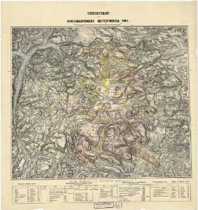
Statistikk 40-2: Oversiktskart over Hardangeviddas beiteforhold

Hardangervidda

Hardangervidda
1 : 200000
Hardangervidda
1 : 200000
Statistikk 40- Oversiktskart over Hardangeviddas beiteforhold

Trigonometrisk grunnlag, Squelet-Cart 4 Kart over de Sommeren 1846 trigonometrisk bestemte Punkter
C. Bassøe
Odda
1 : 250000 Army map service
Kroki over terrænet mellem Breifonn og Blyvardenuten
1 : 100000 Usmund Seim | Olaf Knutsen Garteig | Finn Qvale
Trigonometrisk grunnlag, Squelet-Cart 43: Kart over de i Sommeren 1847 trigonometrisk bestemte Punkter
C. Bassøe
C34 nø/4
1 : 100000 Hjalmar Skaar
Geologisk kart 111b: Hardangervidda - Flacheliefs
1 : 200000 P. U. Thomsen | K. Schipull Hamburger Geographische Studien
Trigonometrisk grunnlag, Squelet-Cart 50: Kart over trigonometrisk bestemte Punkter i Røldal og Suldal
F. Næser
Kartblad 22 vest: Vei-Kart over det Tindske Compagnie District; vestre del
J. Dop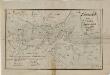
Kartblad 136: Situations-Cart over det Nordre Hardangerske Compagnie District
Lauritz Brix Grøn
D35
1 : 100000 Toralf Øyen
Museumskart 217-42: Specialkart over Hardangerfjorden. Østre del.
1 : 100000 M. T. Kingo | R. M. Petersen | H. N. Bergh Den Geografiske Opmaaling
Kroki over en del av Haringvidda
1 : 100000 Finn Qvale
D34-1; D34-2; D34-7; D34-8
1 : 100000 Thorolv Ingar Ween
D34-3; D34-4; D34-8; D34-9; D34-10
1 : 100000 Thorolv Ingar Ween
Portefølje nr 29
1 : 100000 W. Næser
Kroki i 100000 over terrænet mellem Breifonn og Blyvardenuten
1 : 100000 Finn Qvale | Usmund Seim | Olaf Knutsen Garteig
Portefølje nr 29
1 : 100000 W. Næser
Portefølje nr 20
1 : 100000 F. Staib
Portefølje nr 28
1 : 100000 F. Sejersted | E. Lund
Kroki i 100000 over terrenget Mogen; Ugleflott; Haukeliseter
1 : 100000 Finn Qvale
Portefølje nr 21
1 : 100000 H. Lassen
Geologisk kart 111a: Hardangervidda - Höhenschichten
1 : 200000 K. Schipull | P. U. Thomsen Hamburger Geographische Studien
Portefølje nr 21
1 : 100000 H. Lassen
Kroki i 100000 over terrenget Snenuten Vassdalseggen
1 : 100000 Finn Qvale