Maps of Scandinavia

Statistikk 26-3a: Grundeiendommense Værdi efter Matrikulen
1 : 2400000
Statistikk kart 11-3: Division judiciaire
1 : 2400000
Statistikk kart 10: Mouvement de la population
1 : 2400000
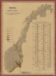
Statistikk 26-3b: Fremstilling af Kongeriget Norges Landbrug. Agerbruget
1 : 2400000
Statistikk kart 16: Norske kirker, med angivelse af lynnedslag
1 : 2400000
Statistikk kart 13-a: Norvège. Division ecclesiastique
1 : 2400000
Statistikk kart 20- Fremstilling af den Norske Fædrift. Hesten. Dyrenes antal pr. 1000 Maal afhøstet areal
1 : 2400000
Statistikk 26-1c: Heste. Antal Dyr pr 1000 Maal høstet Areal
1 : 2400000
Sweden & Norway.
1 : 7400000 Mitchell, Samuel Augustus
Statistikk 26-2a: Grundeiendommenes Udstykning i Klasser
1 : 2400000
Spesielle kart 62: Pflanzengeographisce Karte über das Königreich Norwegen
1 : 2000000
Sweden and Norway.
1 : 6462720 Tallis, J. & F.
Statistikk kart 23: Les marchandises exportees
1 : 2400000
Spesielle kart 66-5: Kart udvisende de med bidrag af Statskassen understøttende Dampskibsrouter
1 : 2400000
Statistikk kart 21-2: Norvege. Pêches.
1 : 2400000
Statistikk 26-7b: Udsæd af Poteter
1 : 2400000
Statistikk kart 4-2: Kart udvisende Folkemængens fordeling i Norge
1 : 2400000
Sweden, Denmark, Norway (outline)
1 : 8500000 Patteson, Edward
Sweden, Denmark, Norway.
1 : 8500000 Patteson, Edward
Statistikk kart 4- Kart udvisende Folkemængens fordeling i Norge
1 : 2400000
Statistikk kart 20-3: Fremstilling af den norske Fædrift. Gjeden. Dyrenes antal pr. 1000 maal afhøstet areal
1 : 2400000
Statistikk kart 22: Tonnage de navires 1873
1 : 2400000
Statistikk kart 20-2: Fremstilling af den Norske Fædrift. Hornkvæget. Dyrenes antal pr 1000 maal afhøstet areal
1 : 2400000
Statistikk kart 11-4: Division judiciaire
1 : 2400000
Spesielle kart 72b: Kart over Valgmands- og Stortingsvalgene
1 : 2400000 K. Petersen Olaf Norli's forlag; Kristiania
Statistikk kart 21- Norvege. Pêches.
1 : 2400000
Spesielle kart 129-1: Oversigtskart over Gradavdelingskarter og Rektangelkarter, bilag 1
1 : 2800000
The Scandinavian kingdoms Norway, Sweden & Denmark.
1 : 4900000 Warner & Beers
Couronnes du Nord.
1 : 12500000 Delamarche, Charles Francois; Lattre, Jean