Maps of Scandinavia

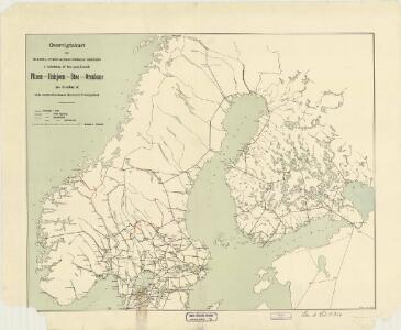
Spesielle kart nr 43. Oversigtskart over de norske, svenske og finske Jernbaner
1 : 2000000 Norsk Lithgr. Officin

Schweden, Norwegen, Island.
1 : 7500000 Haller von Hallerstein, Friedrich; Reichard, C. G.
Sweden and Norway.
1 : 9600000 Moll, Herman, d. 1732
Nordeuropa 1820
Nordeuropa Kunz, Andreas ; Röss, Wolf ; Johnen, Bettina ; Moeschl, Joachim Robert
Nordeuropa 1949
Nordeuropa Kunz, Andreas ; Treiling, Thomas
Nordeuropa 1814
Nordeuropa Kunz, Andreas ; Treiling, Thomas
Nordeuropa 1937
Nordeuropa Kunz, Andreas ; Treiling, Thomas
SYNOPSIS PLAGAE SEPTENTRIONALIS sive SUECIAE DANIAE ET NORWEGIAE REGN. accuratissime delineatum
1 : 4500000 Dánsko Seutter, Matthäus studio Matth. Seutteri
Synopsis plagae septemtrionalis sive Sueciae Daniae et Norwegiae regn. accuratissime delineatum
1 : 4500000 Dánsko Seutter, Matthäus Rogg, Gottfried studio Matth. Seutteri
Synopsis plagae septentrionalis sive Sueciae Daniae et Norwegiae regn. accuratissime delineatum
1 : 4500000 Dánsko Seutter, Matthäus studio Matth. Seutteri

Nordeuropa 1809
Nordeuropa Kunz, Andreas ; Treiling, Thomas
Svecia Et Norvegia cum confinis. [Karte], in: Gerardi Mercatoris et I. Hondii Newer Atlas, oder, Grosses Weltbuch, Bd. 1, S. 96.
1 Karte aus Atlas Mercator, Gerhard und Hondius, Jodocus Jansson, Jan
Nordeuropa 1815
Nordeuropa Kunz, Andreas ; Treiling, Thomas
Nordeuropa 1905
Nordeuropa Kunz, Andreas ; Röss, Wolf ; Johnen, Bettina ; Moeschl, Joachim Robert
Spesielle kart 130-1: Folketæthed Efter Norges officielle statistik ...
1 : 2800000
Schweden und Norwegen
E. von Sydow's Schul-Atlas in sechs und dreissig Karten Sydow, Emil von bei Justus Perthes
Suede, Danemark.
1 : 4650000 Andriveau-Goujon, J.
Suecia Et Norvegia cum sonsiniis [Karte], in: Gerardi Mercatoris Atlas, sive, Cosmographicae meditationes de fabrica mundi et fabricati figura, S. 133.
1 Karte aus Atlas Mercator, Gerhard Montanus, Petrus
Nordeuropa 1871
Nordeuropa Kunz, Andreas ; Röss, Wolf ; Johnen, Bettina ; Moeschl, Joachim Robert
Nordeuropa 1914
Nordeuropa Kunz, Andreas ; Röss, Wolf ; Johnen, Bettina ; Moeschl, Joachim Robert
Sweden & Norway.
1 : 7400000 Mitchell, Samuel Augustus
Sweden & Norway.
1 : 7400000 Mitchell, Samuel Augustus
spesielle kart 129-2: Oversigtskart over Gradavdelingskarter og Rektangelkarter, bilag 2
1 : 2800000
Spesielle kart 130-3: Oversigt over salg av rektangel- (gradavdelingskarter) pr. aar i tidsrummet 1910-15.
1 : 2800000
Nordeuropa 1865
Nordeuropa Kunz, Andreas ; Röss, Wolf ; Johnen, Bettina ; Moeschl, Joachim Robert
SVECIA, | DANIA, ET NORVEGIA, | Regna Europæ Septentrionalia.
Iuxta Archetypum Andreæ Buræi de Boo, | Secretarij Regij, et supremi Regni Sueciæ | Architecti. [Amsterdam : Joan Blaeu]
[Skandinavien]
Skandinávie