Maps of Akershus

Spesielle kart 20-1: Christiania-Lillestrøm-Eidsvold
1 : 400000 Albert Cammermeyer Forlag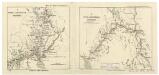
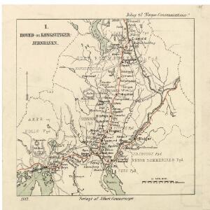
Spesielle kart 20: Hoved- og Kongsvinger-Jernbanen
1 : 400000 Albert Cammermeyer Forlag
Trigonometrisk grunnlag, vedlegg 57-1
1 : 50000
Trigonometrisk grunnlag, vedlegg 57-2
1 : 50000
Trigonometrisk grunnlag, vedlegg 56
1 : 50000
Geologisk kart 39: Den Geologiske Undersøgelse, Nannestad
1 : 100000 Norges geologiske undersøkelse
Spesielle kart 20-2: Lillestrøm-Kongsvinger-Charlottenberg
1 : 400000 Albert Cammermeyer Forlag
20A Nannestad
1 : 100000 Johan Ferdinand Nordmann | Ole Engh
20A Nannestad
1 : 100000 Johan Ferdinand Normann | Carl Christian Olberg
Kart over iernbanelinie fra Christiania til à ̃ieren og Mjà ̧sen, tilligmed Vandlinien fra à ̃ieren til Mjà ̧sen
1 : 20000 Holcks Attelier
Spesielle kart 103-: Flötningskart over Glommens vassdrag
1 : 1000 Einar Sigurd Ween
Trigonometrisk grunnlag, vedlegg 53: Kart over endeel Triangler
1 : 50000 N. S. Darre
Geologisk kart 10 Nannestad
1 : 100000
Geologiske kart 30: Den geologiske Undersøgelse, Nannestad
1 : 100000 T. Ch. Thomassen | Normann | Johan H. L. Vogt Norges geologiske undersøkelse
20A Nannestad
1 : 100000 Carl Christian Olberg | Johan Ferdinand Normann
20A Nannestad
1 : 100000 Johan Ferdinand Normann | Carl Christian Olberg
Trigonometrisk grunnlag, vedlegg 59
1 : 50000
Trigonometrisk grunnlag, vedlegg 58
1 : 50000
Kartblad 42: Vej-Cort over det Ullensagerske Compagnies District (Under Norske Jægerkorps)
C. Hals
Kartblad 43: Wej-Cart over det Næsiske lette Infanterie Compagnies District

20A Nannestad
1 : 100000 Johan Ferdinand Normann | Carl Christian Olberg
20A Nannestad
1 : 100000 Johan Ferdinand Normann | Carl Christian Olberg
20A Nannestad
1 : 100000 Johan Ferdinand Nordmann | Ole Engh
Portefølje nr 32
1 : 100000
Spesielle kart 35: Oversigtskart over de mellem Christiania og Hadeland udstukne Linier
1 : 100000
Portefølje nr 32
1 : 100000
Portefølje nr 32
1 : 100000 F. Akrell
Finmarkens amt 54-2: HÃ¥ndtegnet kopi av kart over Ã...rdalstangen
1 : 200000 Fredrik Rode, Gerhard Munthe
Portefølje nr 24
1 : 100000