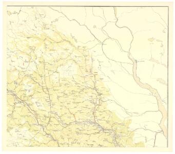
Maps of Nordre Land

Spesielle kart 123-3: Kart over Drammensvassdraget
1 : 100000 Toralf à ̃yen
Spesielle kart 58-1: Kart over Drammenselvens Flødningsdistrikt
1 : 100000 Thurmann | Seip
Kartblad 68: Wey-Cart over det Yttre Valderske Compagnie District
Lauritz Nagel
25D Lillehammer
1 : 100000 Einar Sigurd Ween | Johan Ferdinand Normann
Trigonometrisk grunnlag, dublett 29-2: Kart over trigonometriske punkter foretatt i 1807 og 1810
Hans Lemmich Juell
Trigonometrisk grunnlag, Squelet-Cart 29: Skelet-kart over Oppland og Hedmark 1807 og 1810
Hans Lemmich Juell
F31 aust Synnfjell
1 : 100000
Trigonometrisk grunnlag, dublett 29- Kart over trigonometriske punkter foretatt i 1807 og 1810
Hans Lemmich Juell
5527 Lillehammer
1 : 100000
Portefølje nr 39
1 : 100000
F31 aust Synnfjell
1 : 100000
Portefølje nr 39
1 : 100000
Kartblad 58: Carte over det Ringeboiske Compagnie District
Jens Bull | Kraft
Kartblad 52: Militært Cart over det Gusdalske Compagnies District
Keilhau
F31 aust Synnfjell
1 : 100000
25D Lillehammer
1 : 100000 Einar Sigurd Ween | Johan Ferdinand Normann
25D Lillehammer
1 : 100000 Johan Ferdinand Normann
25D Lillehammer
1 : 100000 Johan Ferdinand Normann | Ole Engh
25D Lillehammer
1 : 100000 Johan Ferdinand Normann
F31 vest Nordre Etnedal
1 : 100000
31A 3; 31A 4; 31A 6; 31A 7; 31A 8; 31A 10; 31A 11; 25C 12; 25D 9
1 : 100000 Ramm
F31 vest Nordre Etnedal
1 : 100000
25D Lillehammer
1 : 100000
Kartblad 62: Charte over det Faabergske Compagnie District

1817-3 Follebu
1 : 50000 Norges Geografiske Oppmåling
1817-3 Follebu
1 : 50000 Statens kartverk
Kartblad 5 Vey-Cart over det Nordre Hedemarkiske Capt. Von Weyhes Compagnie District
Johan Henrik Ramm
1717-2 Synnfjell
1 : 50000 Statens kartverk
25D Lillehammer
1 : 100000