Maps of Snåsa

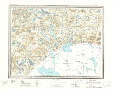
51C Jævsjø
1 : 100000
51C Jævsjø
1 : 100000 H. Hagen | Arnt Magnus Andreassen Øgaard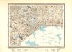
51C Jævsjø
1 : 100000 Arnt Magnus Andreassen Øgaard | H. C. Wanggård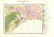
Geologisk kart 83: Geologisk kart, Jævsjø
1 : 100000 Steinar Foslie Norges geologiske undersøkelse
51C Jævsjø
1 : 100000
51C 7; 51C 11
1 : 50000 August Geelmuyden Spørck
1823-2 Gjevsjøen
1 : 50000 Statens kartverk
51C 9; 51C 10
1 : 50000 Hans Gjestvang | Ole Hagbart Bertrand Norgrenn
51C 5; 51C 6
1 : 50000 Hans Gjestvang
51C Jævsjø
1 : 100000 H. Hagen | Arnt Magnus Andreassen Øgaard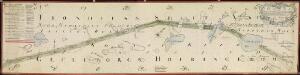
NRA GA 11
Holm | Thodal | Friedenreich | Krogh | Marelius | Ratkind
54A 2; 54A 3; 54A 4; 54A 8
1 : 100000 Thorvald Prydz
1823-3 Snåsa
1 : 50000 Statens kartverk
51C 8; 51C 12; 51D 5; 51D 9
1 : 50000 Reinald Fritjof Valdemar Gulbrandsen
1923-3 Blåfjellhatten
1 : 50000 Norges Geografiske Oppmåling
1923-3 Blåfjellhatten
1 : 50000 Statens kartverk
1823-3 Snåsa
1 : 50000 Norges Geografiske Oppmåling
1823-3 Snåsa
1 : 50000 Statens kartverk
1823-3 Snåsa
1 : 50000 Norges Geografiske Oppmåling
1823-3 Snåsa
1 : 50000 Norges Geografiske Oppmåling
1823-3 Snåsa
1 : 50000 Statens kartverk
51A 5; 51A 9; 51C 1; 51C 2
1 : 50000 Thorlak Aas
1923-3 Blåfjellhatten
1 : 50000 Norges Geografiske Oppmåling
1923-3 Blåfjellhatten
1 : 50000 Statens kartverk
1923-3 Blåfjellhatten
1 : 50000 Statens kartverk
Liene
1 : 250000
Statistikk 43-18-2: Bosettingskart over Grong. Blad 18
1 : 250000 Statistisk Sentralbyrå
Statistikk 43-18- Bosettingskart over Grogn. Blad 18
1 : 250000 Statistisk Sentralbyrå
Kartblad 170: Carta over det Snee-Aasensche Hr. Major Klüwer andfortroede Compagnie
Christian Wilhelm Klüwer | Lorentz Diderich Klüwer (d.e.)